5 Steps to a Stormwater Monitoring System
Editor’s Note: The following transcript has been edited for readability and the video was edited to start at the 1:55 mark.
Video Transcription
Transcript by Speechpad
Hello, everyone. Welcoming you to our webinar about stormwater today.
Today, I'm going to talk about what stormwater is, and I'm going to give you three really great examples that we've been involved in related to stormwater monitoring. And we're going to use that to sort of help you understand then what the five big steps are that everybody really needs to go through to set up a stormwater monitoring system.
One of our first questions is, how many gallons of water will fall within a square mile during a storm, and this is on average? So, Courtney, why don't we go ahead and launch that poll? All right. Looks like we're done with that poll, and if you selected the answer of 17,380,000, you just got entered to win one of those gift cards. So, it looks like that's going to work. I'm excited about that. I think it's going to be a lot of fun for us today. It's going to present some nice breaks in the webinar as well.
So let's talk about what stormwater is. Now, if you live in a rural environment, rain really infiltrates into the ground largely, but when there's really heavy rainfall, there might not be enough time for that infiltration to happen, or the ground can become saturated. So, any excess water will start flowing off into rivers, creeks, any adjacent tributaries. Sometimes even seasonal snow and ice melt contribute to runoff in those rural areas.
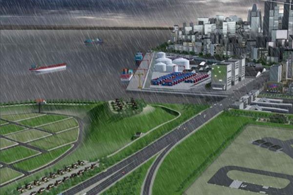
Now, in cities and more human-engineered types of spaces like airports and oil refineries that we'll talk about today, you know, a paved surface or a rooftop is designed to be impervious to water. So all of that water rapidly collects during a storm, and we've all seen that in our neighborhoods in cities if that's where you live. So, ultimately, the coastal regions, ports, and harbors, that is where that water is going to go. There's kind of a local stormwater collection effect, but then there's more of a global effect where all of that runoff, whether it's carrying nutrients or industrial waste, even just things like trash and some of the types of waste that you might see on city streets, all of that gets pushed out to those environments.
Of course, one of the big problems is this is also related to flooding, and so...oh, doesn't look like my slide's moving. Let's give that another shot. There we go. We're seeing a lot of this recently and even just within the last couple of weeks. For example, Ida has just dumped buckets of water along the Eastern Seaboard here in the United States. And it's very clear that a lot of our cities are going to struggle. They're going to struggle to keep up with these increased patterns that are climate change-driven.
And, by the way, in case you're wondering whether climate change actually is playing a role or whether we just think of this more because we're kind of paying more attention, the fact of the matter is that there is more precipitation now than there used to be. And with every degree of warming, the changes get larger in terms of mean temperatures, which, of course, play a role in driving the precipitation patterns. I'm a huge fan, and some of you have seen me posting on LinkedIn recently about the interagency report from the UN on climate change. And this figure is from the summary for policymakers. I really encourage people to take a look at that. This summary is very digestible and really will help you understand some of what's going on on our planet with increased precipitation patterns. (Learn more, Three Stormwater Solutions for a Changing Climate).
But, of course, the problems on the ground that this present, if you're in a city, for example, with older infrastructure, you may be familiar with combined sewer overflows or CSOs as they're known. We have a big project right now on the Eastern Seaboard to set up flood monitoring sites so that traffic can be rerouted during these types of storms because they're so frequent now that that's a real problem. People get stuck on the roads. Of course, pollution is always an issue that we in environmental monitoring are really concerned about, and us environmental folks have been paying attention to erosion and sedimentation for a long time, I've been paying attention to that because that's how I came to this topic through my studies of harmful algal blooms.
Stormwater can be any type of excess water precipitated by storms, no pun intended there, that runs into tributaries, rivers, lakes, streams, and ultimately gets into the ocean in the long run. It can be rural or urban in origin. And even though a storm and stormwater is a very intermittent event, it is happening more frequently and more severely than it ever has before. So this is a problem really for everybody that's involved in water monitoring and water management, particularly in urban areas, I think.
I wanted to give you some examples of how monitoring then is being used to adapt and respond to the stormwater challenges. So the reasons that people monitor for stormwater, I've mentioned some of them already, to support a sewer system program, detection of point source discharges is a big one. And if we have folks from the regulatory space here, you know that stormwater monitoring is a big part of the regulatory world, and we're going to talk a little bit about that with one of our case studies. But even non-point source pollution, such as nutrient runoff that can fuel harmful algal blooms and the NPDES permitting process that is devised to address both types of pollution. If you have an NPDES permit, stormwater monitoring is really something if you're not engaged in, you probably should be engaged in. But, of course, developing TMDLs for listed water bodies, and this is very North American centric. But I think a lot of areas of the world have very similar programs for monitoring daily loads, whether it'd be of nutrients, mercury, other types of runoff that are highly relevant in different areas.
Why do people monitor for stormwater?
- Support of a Municipal Separate Storm Sewer System (MS4) program
- Detection of point-source discharges; industrial facilities and construction activities
- Evaluating non-point source pollution of waterways; nutrient runoff in agricultural watersheds
- Application for or compliance with an EPA National Pollutant Discharge Elimination System (NPDES) permit
- Development and monitoring of Total Maximum Daily Loads (TMDLs) for Section 303(d)-listed water bodies
So, before we go on, let's do another one of those questions, one of those trivia questions. We just talked about MS4s being one of the areas that are affected first by stormwater, and the question is, how many MS4s do you think there are in the U.S.? How many permits? So, Courtney, let's go ahead and launch that question. Okay. Looks like we're done with that one. The answer was 7,250, so kind of a middle-of-the-road answer there, similar to back in the days when you took multiple choice exams, right? B or C was usually your best choice.
All right. So, let's move on then, and I want to tell you about three examples that YSI has been involved in sometimes with other partners. Often, the customers are the most important partner in designing, excuse me, some of these stormwater systems. So, we're going to talk about three examples here in the U.S.
The first one, and this is one of those things that I learned that I didn't fully understand. So, being in environmental monitoring for years, of course, I was familiar with the NPDES program of the U.S. EPA. What I didn't realize was that there's a whole section of that program that is just about stormwater, and I would encourage you to go online and take a look at that. Within that stormwater segment of the program, they recognize five major areas where stormwater is a real problem for pollution discharges. One is construction sites. Makes a lot of sense. I hadn't thought about it before. Of course, industrial runoff and municipal runoff are things that I have thought about. I had thought about transportation. I didn't realize that the oil and gas industry is also heavily monitored. Maybe I would say rather than regulated when it comes to stormwater discharges. (Learn more, On the Level | Stormwater Monitoring for a Refinery's NPDES Permit).
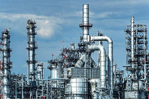
We had an interesting situation recently where a contractor that works with YSI and has worked with us in the past was working with an oil refinery in the State of Texas. Now, refineries, if you've ever been around one, you recognize that refineries are like little cities. They're really big, lots of paved surfaces, lots of metal, things that water is just going to bounce off of. But, of course, the things going on there are also not necessarily the things you want running off into your waterways, and some of the main concerns I've listed here. There are all types of different fuel products and petrochemicals that are at those sites that, you know, for better or worse, do get spilled, or they are in an area that can be compromised by stormwater.
And so the approach that refineries often take, and this is a very smart approach, is, you know, it's really hard to monitor for these things in runoff directly. So what they do is establish an average pollutant concentration in stormwater. So, during a number of stormwater events, they actually collect samples and catchments that surround the refinery to try to understand on average how many of these pollutants they might discharge. The problem is that doesn't necessarily tell you how much of those pollutants are going to reach a river. And so what some of these more proactive refineries are doing, very smartly I might add, is they're actually setting up monitoring systems of their own in some of those rivers, lakes, streams that are downstream of their stormwater discharges. You know, this allows them to sort of ground truth whether their estimates of what's going on at the plant really correlate with what's going to go on in the downstream discharges. So what they can do is collect samples during a storm downstream, and really understand the relationship between those immediate estimates and the downstream discharges. This allows them to then just collect volumetric flow to estimate their discharges. This gives them a way to back up the discharge measurements that are also being made by a regulator, and so they're working in cooperation with their state regulators to really understand what their pollution impact is.
This situation for this refinery, they started with what's called an IQ. A SonTek-IQ is a Doppler instrument that allows you to measure volumetric flow. And they coupled that with a storm data logger and telemetry, allowing them to constantly get cellular readings, I'm sorry, cellular transmissions of the readings from the SonTek-IQ. So the SonTek-IQ is giving them that volumetric flow measurement. The storm and most of the electronics are housed in a case that contains the power system, which is battery, but it is solar recharged. And then the data are being sent to HydroSphere data management platform. So they can constantly see the flow in the downstream river during...anytime actually, not just during an event. And by doing this, they are able to always keep track of what their discharges likely are based on those early estimates just by measuring volumetric flow. This is a very cost-efficient way to do long-term stormwater monitoring from a site like a refinery.
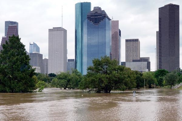
The second example I wanted to give you, which is highly relevant today, relates to hurricane monitoring. This, of course, is generating a lot of stormwater runoff for people today. The case I want to talk about comes to us from the State of Texas where we have two regions that are being monitored by the Texas Commission on Environmental Quality. They have a large program, an excellent program, called the Clean Rivers Program, and a lot of stakeholders in the state can engage with that program. The stakeholder we're talking about today is the EIH, the Environmental Institute of Houston. They were doing monitoring on creeks in two regions in Texas, the San Jacinto-Brazos region and the Brazos-Colorado region. The actual site I'm going to talk about today is where the star is placed. They installed stormwater monitoring sites, continuous monitoring sites in 2017. They did that early in the year, and it ended up being quite timely because, in August of that year, Hurricane Harvey hit Houston. And some of you may remember a lot of tragedy around Hurricane Harvey and the flooding that ensued.
The way they had set up their system was very interesting and very instructive. They did some pre-installation work, just understanding discharge that happened in these creeks they were interested in. So they used SonTek's FlowTracker2 as well as a SonTek RiverSurveyor M9 to understand what's called instantaneous discharge measurements. So using a surrogate, understanding the flow rates using...this is called a passive sampling approach where they can basically have the M9 on a board and understand discharges as they occur across that creek in normal conditions. They can also do that a number of times and at the same time collect stage or level measurements, and they can create something called a stage discharge relationship. When the water level is this high, my discharge is this much, for example. By doing that preliminary homework, then they were able to install stations that included an Amazon bubbler. This is a bubbler for measuring water level. So this is how they are measuring stage in a continuous fashion without someone having to be on site all the time. They, of course, had another storm data logger, and in this case, they had a GOES radio for doing transmissions. They were using satellite. They have the data going up to hydrosphere, but in the case of EIH, they're actually processing that data and putting it on their own website so it is always available to the public. And you can learn more about that at their website. This is battery-powered, that is critically important, and this is also being solar recharged.
Now, during Harvey, the level in those creeks rose seven to eight meters at two of the monitoring sites that we looked at. The data are available on that, but seven to eight meters of change. They were able to use those stage measurements with those discharge relationships they had previously built to better understand potential pollution that went through those creeks during that stormwater event. Of course, also understanding just the level change is really important. From a roadway protection, you can see there's a bridge here in the background. That's really valuable information for them to have and to provide to the public as well.
The third case I'm going to talk to you about is the Terrebonne Levee in the Gulf Coast of the United States. Of course, this region is very frequently hammered by hurricanes even more so today. But in this three-year period, they experienced a lot of really big hurricane events such that a citizen group formed and started working with one of our customers, the Delta Coast Consultants Group. This group has these barge gates that are actually manually operated. So it still requires an operator to know how to manage the flow through these gates. And this is part of the broader flood protection in the region.
We have an app note about that if you want to read more about how those gates work. It's really, really fascinating. And we also have an article in "Mission: Water Magazine" if you want to look at that. (Learn more, Closing the Gates | Helping Communities Battle Storms). But in the long run, what they needed to do was they needed to always understand level, always understand flow, but they also wanted to see what was coming. And so doing weather monitoring and understanding the rain patterns in the region was really important to them. So they needed to know more than just the national weather service forecast. They needed to know, "What's happening here in terms of my rainfall? And what does that mean for me in terms of how fast that water is going to rise?" (Learn more, On the Level | Flood Monitoring for Coastal Resilience).
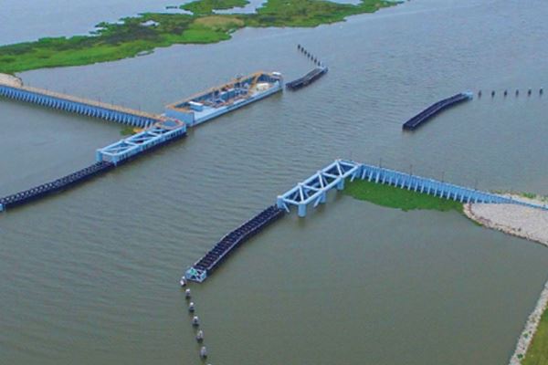
They wanted a non-contact sensor for water level. In this case, that was a Nile Radar non-contact water level sensor instead of a submersible water level. Of course, when you look at the size of that barge, the site, it makes a lot of sense to have something sitting above that water that's not going to get washed away in a very powerful flood, but also that is secure enough to see, you know, very minor changes in water level because when you have that much surface area, it's a lot of volume. So, they put a SonTek Side-Looker similar to the IQ, but it's a different positioning of doing Doppler radar for looking at flow. And they had multiple stations that combined the Side-Looker with the radar, as well as a tipping bucket rain gauge so that they were always keeping an eye on the local rainfall.
Really important in this site was to have redundant power and redundant telemetry. So they were using both satellite and cellular telemetry at these sites. This is actually really important in general as we'll talk about it a little bit more. So in the end, this system has allowed them to weather a number of storms since it was installed in, I think, 2017 when this was installed. So that's another example of combining technologies to do stormwater management for a very different purpose than the other two that we've looked at before.
So in the end, what these all had in common, and what we're going to talk about going forward is that each one of these cases had to define what to measure. You have to start with what your real objective is before you start stormwater monitoring. And that's something I had to learn as I started really looking at stormwater monitoring. I thought there would be...I thought, "Okay, measure level." I thought you just weathered water stage, and obviously, these cases show you that there's a lot more to it than that. Power and telemetry are paramount, and wherever possible, redundant. And it also is hugely helpful to have real-time visibility to the data. That is why that telemetry was so important because, obviously, you're trying to get away from the storm in many cases, but you need to be able to see the data coming in and have a reliable system for delivering that data even when power is lost in a region. So, they did have some other elements that I didn't talk to you about yet, but I hinted at and that we're going to talk about when we talk about these five steps.
What did all three stormwater monitoring programs have in common?
- Each case defined what they needed to measure
- Power and telemetry were paramount (and redundant)
- Real-time data visibility and alerts aided management
This is our third trivia question, channel erosion, habitat degradation, and the potential for contamination of drinking water sources are significant concerns when effective impervious cover of a watershed exceeds what percent? Courtney, let's go ahead and launch that poll. That's a really good question. It's an interesting question when you think about the differences between rural and urban environments since stormwater.
Vijaya had asked how the downstream monitoring system was placed in the water. And I think, Vijaya, you were talking about how it's anchored, and that's related to that oil refinery system. So, that box that we showed to you is sitting beside the river, actually a little bit up the bank from the river, and is bolted down. So that box is sitting there, and then there's a conduit that delivers the power. And the SonTek-IQ is actually anchored to a block that is in the river. And so the way it's anchored, you have to actually calculate for its distance from the bottom to get a very good measurement of water level and flow as it changes in that river. I love that question because it shows that it's not just a matter of throwing this stuff out there. There is design and experience required to understand how to install these types of systems. So that's a really excellent question, Vijaya, and I appreciate you asking it.

Another question was whether the bubbler had any advantages over ultrasonics or radar in these types of applications. That's an excellent question coming from Haroon in Pakistan. The answer is there are some advantages. One of the things that I like about bubblers, first of all, they are super easy to use, so easy, and they're a little easier to install as well. But the other nice thing is, you know, a bubbler just has water pressure pushing that bubble out of an orifice tube. If the water goes dry, you know, if you're working in one of those intermittent tributaries that only has water in it during stormwater, a bubbler is an awesome solution because you don't get any interferences. You know, with a radar and ultrasonic, if that creek bed goes dry, a lot of times you get these weird transmissions back to the sensor because all of a sudden, you're exposing rocks, and that surface can change. You don't have any of that to worry about with a bubbler. So, I love bubblers for stormwater monitoring. I think they're a great solution when you're in those sites that are tributaries that are not always filled with water.
All right. So, answering those questions, what was the answer to this trivia question? It was 25%. Really interesting answer when you think then about the fact that at an oil refinery and even in smaller cities, you readily get to 25% coverage with impervious surfaces when you think of rooftops and everything else. So, I think that demonstrates why stormwater is such an issue for our urban areas, which are growing, by the way. All right. So, I really appreciate everyone's engagement. Keep asking great questions, and let's talk about what those five steps are. Hopefully, these case studies already have you thinking about what some of those steps are.
Determine What You Will Measure - Start with the Objective

One of them I always already hinted at is, don't start with your sensors, and this is where I was confused when I first started learning about stormwater. I'm like, "Okay. I need a water level sensor. I might need flow. I don't know." Don't worry about that yet. Just start with what your objective is. So, for that levee, their objective was to know how to manage those barge gates and what information did they need to know how to do that? For that oil refinery, their objective was completely different. They wanted to really understand what their discharges were related to their permitting levels. Completely different, and you have to take a different approach. So don't come at it immediately thinking about, "Oh, I need this sensor or that sensor and so forth." Think about what your actual objective is, and the answer to the sensor question will usually then emerge from that. You'll have to refine that answer then by the environment and the site itself and what types of sensors you can actually place there, but always start with your objective.
Now, I talked already about types of sensors. I talked about three in specific, weather sensors, level sensors. We talked about a radar. We talked about a bubbler. There are also pressure transducers, ultrasonic sensors. All of these are things that YSI provides. I didn't talk about water quality, and I do want to touch on that briefly because we talked about it in the context of the oil refinery who took a very different approach to water quality doing those early measurements. But another way to approach water quality, of course, is to put a water quality monitoring sonde or some other type of continuous measurement device right in the water that is the receiving water for the stormwater.
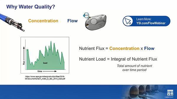
By measuring the concentration of a potential pollutant, for example...oops. Sorry. By measuring the concentration and measuring flow, you can understand flux and loading. This is one of my favorite examples because, of course, it's highly relevant for harmful algal blooms. By understanding, if you put a NitraLED sensor, for example, in a river that is receiving a fertilizer runoff, you're going to get a really good idea of what the loads, the nutrient loads are going downstream of that river, and which might stimulate a harmful algal bloom. So this is a really good example of measuring water quality if that's part of your objective if it makes sense for the objective that you have in your stormwater monitoring.
Define the Sampling Regimen
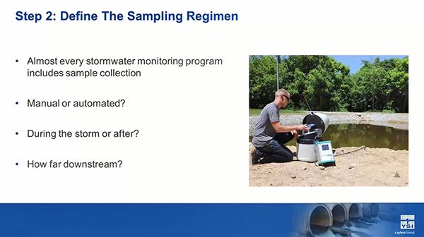
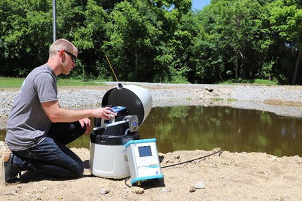
The second step, and we didn't talk much about this one, almost always, almost always somebody is going to go out and collect samples in a storm event. They may go out the day after the storm while those water levels are really high, and they want to understand if a certain pollutant has been introduced into the water. You need to decide how you're going to do that. Are you going to do it during the storm or after the storm? Are you going to do it in a manual or automated fashion?
So, for example, Chris here is setting up an automated sampler. These are pretty nice because you can leave them out there during the storm. You don't have to be out there, but you can trigger that sampler to collect samples based on a water level, based on a turbidity level, based on some combination of the two. And you also need to decide where you really want to place that, and this, again, always is going to tie back to your objective and what it is you need to know. So, you're going to need some sort of a sampling program 9 times out of 10 with stormwater monitoring. Now, if you're just monitoring for flooding, that might not be necessary for you. We find that often people are monitoring for more reasons than just that.
Define the Notification Requirements
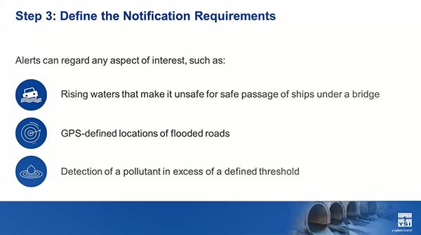
The third step for defining your stormwater monitoring system is, do you need to receive notifications, and if so, related to what? Always tying back to your objective. Now, sometimes...so, for example, let's talk a little bit about that sampling. Let's say I told the sampler to collect a sample when turbidity exceeds 100 FNUs and the water level is at 9 feet. (Learn more, Turbidity Measurements: Tips and Precautions). I want to know if that sample was collected because the next day, I need to go out and get it. You know you want to know. Even if you're doing automated sampling, you're going to want the telemetered information to tell you that that sample has been collected. But you can also get notification requirements for any number of reasons, some of which are shown here. If you're monitoring for a pollutant directly in the water, which is very handy, again, if you're using something like NitraLED, maybe that's the only time I want to know is when I've exceeded some limit. This is also highly relevant for NPDES permitting. So define when, where, and how you want to get your notifications.
The fourth step...I'm sorry. Still here's an example of your notification requirements. I love this example. It comes to me from my colleague. She has a monitoring site in Georgia called the "Tanyard Branch." And in this case, she wanted to collect samples and receive notifications based on turbidity. What's interesting here is she was monitoring turbidity at this site and she knows that, when it comes to turbidity, you may get fouling of that sensor, particularly after a stormwater event. And she set an alert, she called it the turbidity fouling test, to let her know that, you know, what I'm seeing in turbidity doesn't quite look right. You might need to go out and service your site. So, in this case, she's not setting an alert just because there's an event. She's setting an alert to also help her understand how to maintain her equipment at the site, really clever approach. (Learn more, Determining the Source of Stream Toxins with Continuous Monitoring).
And this is a beautiful example of how that worked for her. So she's been monitoring turbidity in this creek, and they got a storm event. They got a big event. There was something like six inches of rainfall. And obviously, the turbidity increased due to that event. But what she saw was...and she's looking at this in the HydroSphere software, by the way, this is her graph directly out of hydrosphere, was the turbidity never did return back down to the normal levels, and she started seeing these really weird spikes in the data. She had set up an alert that said whenever the turbidity is greater than 30% of the average of my most recent 96 samples, and the water level is less than 1.95 feet, in other words, it was starting to come back down, I want to get an alert." And indeed she did get an alert, and she went out. And what had happened is during that storm event, her sonde had gotten covered with a lot of sediment, and the turbidity readings simply weren't right. If she hadn't set this alert, she might have continued collecting a lot of data that wasn't going to be useful to her by having not gone out and done that maintenance. And sure enough, when she went out and did that maintenance, stuff got back down there below a couple of FNU as she was used to seeing.
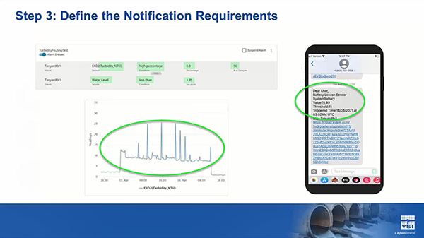
Another example of an alert she received, she also set an alert for when the battery power was low at her site, really important for stormwater monitoring. If you've got a battery-dependent system, you need to know if you need to go out...if you're getting enough sunlight to recharge it, if you need to go out and replace it. Another great example of using alerts to help you in your stormwater monitoring system.
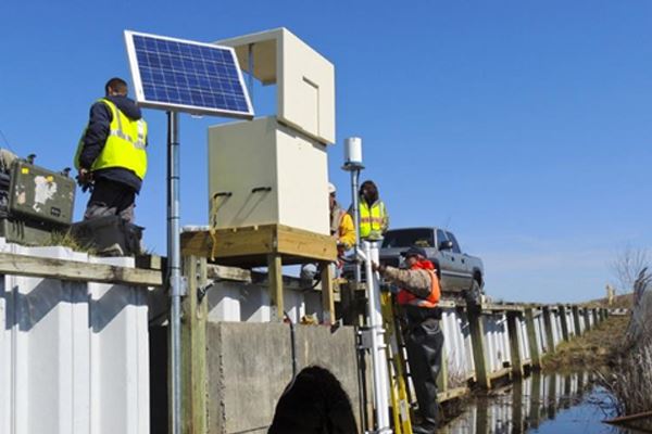
Review the Power Requirements
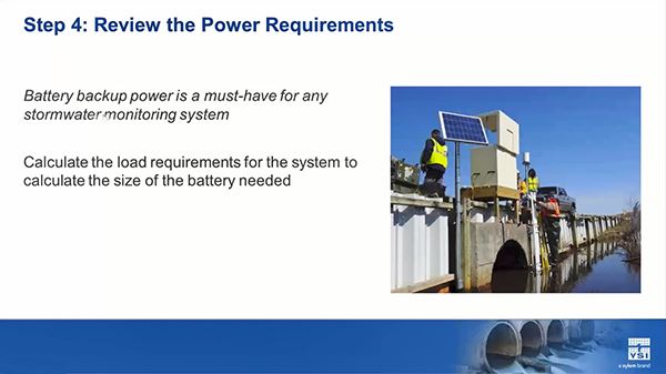
All right. The fourth area, and boy, people have made this mistake a lot. So, listen up, power. When we start talking about samplers and sensors...and some of these sensors are optical sensors. The Doppler sensors always have to have hard power to them. When we start talking about that, you really need to understand the load requirements of those sensors and how much power you have to set that station up with. The ideal situation is to have redundant power. A lot of these systems are set up with mains power, and then the battery is a backup. Some of these systems have dual batteries because during a storm, who knows what's going to happen? Or you're in such a remote area, you can't tap into any type of mains power. Obviously, it's always helpful to have solar recharging of that system so that when there isn't a storm, that power stays good. And as we saw in the last example, really monitoring the power on your stormwater systems is really, really important because, boy, you don't want those things to fail in a storm because you forgot to change a battery. So, understanding how much power you're going to need at the site, how you're going to get it there, how you're going to keep it charged, and keeping an eye on the power is going to be really, really important. I never recommend having single-layer power for a stormwater monitoring system in particular.
Secure the Equipment
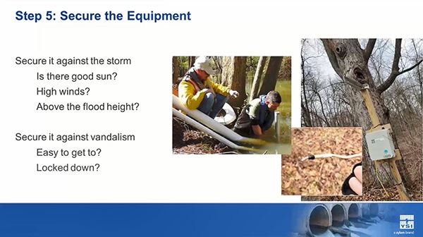
So, the last step, and this is going to seem obvious, but, you know, we had a question that was a really good question about how you secured that system for that oil refinery system that was on a riverbank basically. You have to secure that equipment so it's not going to get washed away during a storm. But you also want to make sure there's good sun if you're using solar recharging of that power system. You know, when we talk about things like a radar, you really need to secure it well on a bridge or some other type of structure that's not going to get blown away during a storm. This is where having someone who's experienced in installing these types of systems can be really, really helpful.
Another thing is we think of placing a sensor like a radar above the height of the water, sometimes not even considering how much that height is going to change during a stormwater situation. If you have any historical data about the flood levels at a site, it's really good to use that in placing your sensors. And then another thing, and this came to some colleagues...came to us from some colleagues at Grace College who did a great webinar with us earlier in the year, securing your site against vandalism to the extent that it's possible. This is a great site they have. It is a stormwater monitoring site, and someone stole their solar panels and cut some wires. I have a site here in Missouri where I am where somebody got a hold of the sonde, took off the sensors, and threw them in a campfire. So, these things happen, and securing your site against vandalism is definitely something you have to think about when you're placing anything in either a rural or an urban environment.
So, before we march towards the close of our webinar, we have one more trivia question for you. Stream channels begin to erode when effective impervious cover of a watershed exceeds what percent? So this is a little bit of a different variation on the earlier question we had. So stream channels begin to erode when effective impervious cover of a watershed exceeds what? So that poll is open for you.
A question came in from Chris, really good question here, are YSI sondes compatible with most SCADA programs? Really important question for stormwater monitoring. The answer is yes, but the reality is that it's not plug-and-play. You'll have to use a signal output adapter that allows the sonde data to be delivered into the SCADA program. And very often with our fully integrated systems, there is some programming that needs to happen in a data logger to get compatible data movement into a SCADA program. That is so important in stormwater monitoring. And what we have found, what experience has taught us is that all SCADA programs seem to be different. It seems like the way one city is implementing and using their SCADA is quite different than the city down the road. And so a lot of times, there has to be a lot of customization of that coding, and a lot of that depends on the types of sensors that are in that system. In other words, there's some engineering work to do there. So that's a really good question, Chris. I appreciate it because it's really relevant for today's topic. So, what is the answer to our question here? It is 10% rather than 25% as we saw previously. That's a really important thing to understand when we talk about channel erosion.
All right. So, what I want to leave you with as we close this up, and I encourage you to keep asking questions, is that these five steps in a lot more detail are available to you in a white paper that I put together earlier in the year. And we're going to give this to you as a handout with this. You'll either get it today. I don't know. Courtney may have already attached those handouts for you. Yep, there it is. Oh, that might actually be the slide. Sorry. So these slides are also attached for you, but this is also attached for you...will be attached for you pretty soon. But this goes through those five steps in a lot more detail, and it may give you an opportunity to think a little bit more about what we've talked about and ask some more questions. And, of course, you can always contact us with those questions.
The last thing I want to leave you with is that as you've heard me indicate, a lot of experience can be very helpful when you're getting started with this. I mentioned already that when I first started looking at this, I was quite overwhelmed when I looked at the variety and types of systems. And there's a lot of knowledge that goes into, how do you mount that system at a site? How do you make sure it's secure? We've done this at YSI a lot, and we have a great team that can help you do this as well. We can help with the design and installation of these types of systems. (Learn more about YSI Systems). The sensor site maintenance is also...the sensor and site maintenance. So, for example, I talked about setting up that alert. We have people that can go out and clean that sonde for you and that can go out and make sure you clear that sediment and clear that brush away from the site. So this type of site maintenance is something else that YSI can help you with, and, of course, just taking care of those sensors, making sure they're properly calibrated, that you're getting the right data. (Learn more about YSI Services). We do this for dozens if not hundreds of people around the world, and we have a lot of options available to you. You can learn more about the services that YSI provides and which can support your storm monitoring program at this link.
So, I want to thank you guys very, very much. I definitely want to thank you guys so much for your attention today. I hope this information was helpful and useful to you. Lots of ways for you to get in touch with us. We have a great stormwater web page that has a lot of this information and has a brochure and things that you might find helpful.
So with that, I think Courtney has one last question for you about how we can help you with your stormwater monitoring. I want to thank everybody for their engagement today, really, really good questions. I'm glad we were able to knock them out. If you have more questions, use those links. You can contact me on social media. Really, really appreciate everyone's great attention today, and I hope you all have a great day. And protect yourselves and have a plan for adapting to our changing climate and the need to do stormwater monitoring. Thank you very much, everybody. Bye-bye.
Summary
What are the 5 steps to developing a stormwater monitoring system?
- Determine what you will measure
- Define the sampling regimen
- Define the notification requirements
- Deview the power requirements
- Determine how to secure the equipment