Monitoring and Ingenuity Help Louisiana Communities Battle Storms
(Updated October 2021)
Terrebonne Parish, Louisiana got the name "good land" from French-speaking settlers — French Canadians evicted by the British in 1755, and another wave of French citizens from New Orleans fleeing the Spanish takeover of their city in 1762.
The rich land was indeed good for growing sugar cane and grazing cattle. But with 987 square miles (2,556 km2) of land and 1,079 square miles (2,795 km2) of lakes and waterways, Terrebonne Parish is actually more water than land.
"We have so many waterways, we're so inundated with water, it's part of life," says Jason Kennedy, one of the founders of Delta Coast Consultants in Terrebonne's largest city, Houma, Louisiana.
"It's the reason people are here, come here, live here."
But all that water also poses a serious threat to the 112,000 residents of the parish (Louisiana's counterpart to a county, a legacy of its origins as a colony of France).
The threat is heightened by the steady loss of elevation of the low-lying landscape. Sediments that used to be deposited by the Mississippi River to build the land are now shunted into the Gulf by a faster-moving, channelized river.
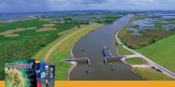
Local initiative and ingenuity are protecting Terrebonne Parish, Louisiana, from storm surges. Since 2007, $414 million has been invested on flood protection in region; locals have paid 57% of the tab.
Banks and barriers are eroded by tidal surges, and as gas and oil deposits are pumped out, the land is dropping an average of 9 millimeters per year. That is a lot to lose when the average elevation of the parish is just six feet (1.82 meters) above sea level.
Terrebonne Parish also sits at the top of a 90-mile-long, shallow coastal shelf, Kennedy notes. When hurricanes spin up the Gulf of Mexico, the shelf builds storm energy into huge surges that slam into the parish and wash over the communities.

In years past, vegetated barrier islands absorbed part of the blow and kept some of the water away from the mainland. But those islands have been starved of sediment for about 80 years, since the U.S. government channeled the Mississippi River to prevent flooding, so they have shrunk dramatically. Now Terrebonne's fishing villages and the parish seat of Houma look storms directly in the eye.
"We have more effect from 25-knot south wind now than we ever had—tremendously high tidal events because of normal frontal passages," Kennedy notes.
"Ahead of a front, 30-knot southeast winds are almost like a little hurricane."
"It seems like the last 15 years, we've had more extreme weather events than we ever had," he adds. That compounds the problem.
Even with tax revenues and other state funds, Terrebonne Parish has had to be innovative to afford its system. For more, visit: www.TPCG.org
Critical Need
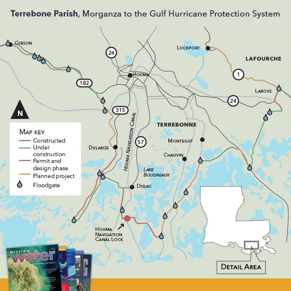
The federal government saw the need for a flood control system through Terrebonne and neighboring parishes, and in 1992, began a study to map out a project. Congressional acts in 2007 and 2014 resulted in authorizations for a $10.8 billion plan—dubbed the Morganza to the Gulf Hurricane Protection System after the town that marks its projected starting point—but the government never funded the projects.
After hurricanes Katrina and Rita in 2005 and Gustav and Ike in 2008, the Terrebonne residents decided to raise their own money to start building the parts of the system slated for their parish. Twice they voted in sales taxes to finance the effort.
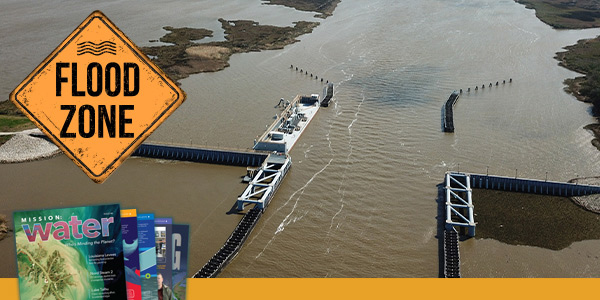
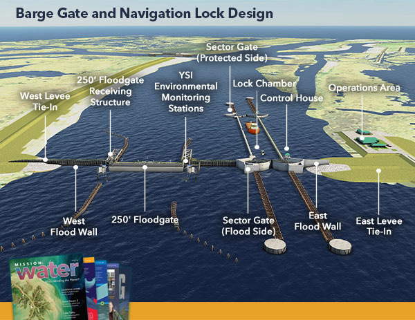
The portion of the Morganza to the Gulf plan now under construction includes 98 miles of levees, peaking at 18 to 20 feet in height. Floodgates manage canals, rivers and bayous—the sluggish outlets of rivers that are characteristic of the region—that pass through the levees, while environmental gates permit flow to wetlands.
Even with tax revenues and the help of cost-share funds from the state, Terrebonne Parish has had to be innovative to afford its system, notes Reggie Dupre, executive director of the Terrebonne Levee and Conservation District. Dupre, born in a small fishing village on the edge of the Gulf, spent years lobbying for the flood protection project as a state legislator representing his home parish. Today, he leads the effort to see it through its construction.
Innovative Gates
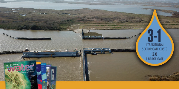
When Dupre started on the Morganza to the Gulf project, there were two arc-shaped, rolling sector floodgates in place, built by the district's predecessor using Corps of Engineers designs. With new design standards and the need to build floodgates to a higher elevation, the cost of building sector gates was very high, he says. Instead of replicating those expensive designs, the levee district adopted a much more cost-effective, local approach called a barge gate.
In the open position, a barge as long as the channel is wide sits on a platform, weighed down by a few feet of water in its hull. One side of the barge is attached to a piling that serves as a pivot, like a hinge on a door.
When a storm approaches, the gate crew empties the water to float the barge off of its platform, then reels in the loose end to shut it like a door across the channel. Once it fully blocks the channel, the crew fills its hull with water to sink it in place on a set of pins, forming a seal on the concrete floor of the channel.
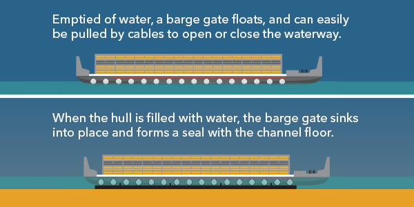
"You're really fighting water with water," Dupre notes.
"They take longer to operate than a sector gate, but once they're closed, they work just as well."
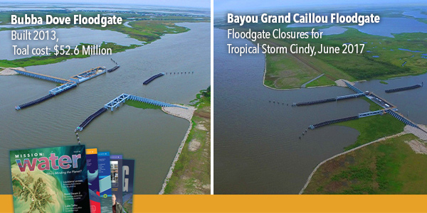
So far, the levee district has built 11 barge gates, each about one-third the cost of a sector gate. The largest and most expensive of the barge floodgates is the Houma Navigational Canal "Bubba Dove" Floodgate, completed in 2013 at a cost of $50 million.
With a 250-foot (76 m) opening, a sill depth of -24 feet (7.3 m) and a flood protection elevation of +18 feet (5.5 m), the Bubba Dove Floodgate is one of the largest in the U.S. Building a sector gate at that location would have cost more than $150 million, Dupre notes.
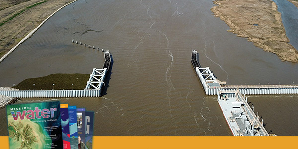
Closing a barge gate is a delicate operation that requires a skilled crew and favorable conditions. Without a slight but steady current pushing against the closing motion, it can be like slamming a 273-foot-long (83-meter), 250-ton steel door shut in a windstorm.
"We didn't have the resources to build these sector gates that can work in adverse conditions, so we have to work with the tides to close them," Dupre explains.
Monitoring is Key
Working with the tides—especially in a system that is half aquatic—requires a close eye on the ebb and flow of water. Over the past three years, Delta Coast Consultants has been working with Xylem to install suites of monitoring instruments on both sides of its many barge gates. These stations provide all kinds of data on parameters like water level, water velocity, water flow and direction, and wind speed and direction. These data are transmitted every six minutes to the levy district's command center.
By the start of the 2019 hurricane season in June, 10 of the parish's 13 floodgates will have Nile radar stage sensors; SonTek-SL (side-looking) velocity, level, and flow meters; RM Young wind sensors; rain gauges and dataloggers.
Closely monitoring stage and flow in real-time has allowed the levee district team to see the dramatic effects of landscape, wind, and tide on surges across the parish. Kennedy points out that an incoming tide at one monitoring system can push an outgoing flow two miles away, and notes that flood stages can vary by half a foot (15 centimeters) from one bayou to another.
Using the technology to both study and monitor water movement in the parish illustrates what makes Delta Coast and the levee district so great to work with, says Lisa Landry, Xylem technical sales rep in Baton Rouge, Louisiana.
"We love how innovative and outside-the-box they are, and how dedicated they are to public safety," Landry says.
One of Terrebonne Levee and Conservation District's barge gates (foreground) stands open. The gate system is being modified to encourage fresh water to circulate among the bayous.
Vital Links
Dupre adds that understanding the dynamics of the system and receiving the data from the SonTek-SLs are vital to allocating his staff resources as storms are blowing in.
"Some of the gates take as many as six people to operate, and they can take an hour and a half to close, as opposed to three minutes for a sector gate," he explains.
"You have 18 operations employees trying to operate 13 flood gates across 60 miles. So this technology becomes very, very important to understanding what's going on and how it affects where you want to send your employees.”
"Without this YSI system, we'd need double the amount of employees, which we can't afford," Dupre adds.
Of course, Dupre's team relies on a constant stream of data in the sorts of circumstances almost guaranteed to threaten communications channels. To keep the information flowing, Kennedy and his staff built in several signal safeguards to make sure that the district's command center is constantly in touch with data from the field.
"The first thing to go out is power," he says. "All these sites have backup power. The next thing to go out is the cell phone towers, so if you lose the cell signal from these, we've got satellite-based contact. It's a pretty mission-critical system."
It takes a team of as many as six workers as long as 1.5 hours to move a barge gate from the open position (left) to closed (right), so timely, accurate data on water velocity, direction and stage is vital to the district.
Public Interest
It didn't take long for residents of Terrebonne Parish who rely on the waterways—the shrimpers and oystermen, the barge haulers, the recreational fishing enthusiasts—to ask for access to the data streaming into the levee district's system.
The district commissioned a public app, then switched to an online service at www.tlcd.org/mobile.
Visitors can click on any of the floodgates that have instruments and get an instant, up-to-date look at flood-side stage, wind direction and wind speed, and the status of the gate. Those who subscribe by sharing their emails and cell numbers can get alerts when the gates are closing or opening.
Kennedy says pilots on the system can use the website and alerts to adjust their routes on the Gulf Intracoastal Waterway and other channels based on gate closures — decisions that can keep them working during changes in the weather or get them home safely as storms close in.
News on the gates also allows them to get back to work after storms blow through.
"Everybody wants to know not only when it's going to close, but when it's going to open," Kennedy notes. "We don't want to keep things closed any longer than we have to. There's so much commercial interest in getting out to the water."
To Kennedy, commercial interest is just one part of what the levee system is being built to protect. "You're protecting life and property of the people who live here,"
he says.
"But the other aspect is you're protecting the culture and the environmental resources. If we were to lose these coastal wetlands, Louisiana would lose its identity. If we lose our coastal wetlands, there's no more seafood, no more crawfish, no more Cajun culture. The communities that have been built here, that's what they're built on."
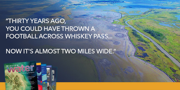
Terrebonne Parish: Losing the Barrier
In the 1800s, Terrebonne Parish farmers grazed cattle on the rich grass that stretched almost out to the barrier islands protecting the wetlands from the Gulf of Mexico. Isle Derniers — "the last island"—was a 25-mile-long (40 km-long) strip of sand laid by the Mississippi River and shaped by wind and waves.
For years, it was a popular resort, lined with summer homes, hotels and casinos until an 1856 hurricane buried the island under five feet (1.5 meters) of water, wrenching the buildings off their foundations and tearing the island into pieces.
That erosion continues today and has picked up speed, says Jason Kennedy of Delta Coast Consultants in Houma, Louisiana.
"Thirty years ago, you could have thrown a football across Whiskey Pass," he says, referring to one of the breaks in the island. "Now, it's almost two miles wide."
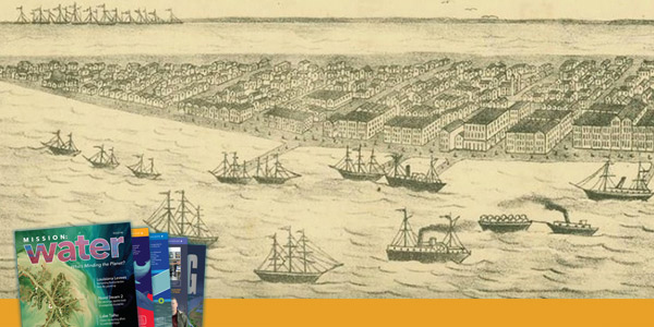
Isle Derniers was a popular resort lined with summer homes, hotels and casinos until a major hurricane buried the island under 5 feet of water (1.5 m) in 1856.
The Mississippi River no longer supplies fresh sediment to rebuild the island, Kennedy explains. Instead, the federal government's channelization of the river shoots sand and silt far out into the Gulf, bypassing the coastal wetlands that were built and continually restored by delta deposits. Without new material, erosion gains the upper hand.
As the passes widen and barriers shrink, waves reach farther inland, then must rush out more quickly than ever to cover the growing distance back to the Gulf. As the water speeds through the inlets, it pulls even more sediment out to sea.
Kennedy hopes the Morganza to the Gulf Project—98 miles of levees, floodgates and a navigation lock—will help manage storm surges not just to protect life and property inland, but also to protect the coastal wetlands from both fast and slow devastation.
LEARN MORE: LA’s Strategic Adaptations for Future Environments: www.LASAFE.la.gov
ON FACEBOOK: www.facebook.com/livelasafe
Additional Blog Posts of Interest
Climate Change Models Guide Decisions in Florida
Drilling into the Abyss | Understanding Sea Level Rise
Irrigation District Relies on Continuous Water Usage Information
Stream Flow Data Improve Ice Melt Models