Remediation Efforts along the Gulf Coast
Great organizations like The Water Institute of the Gulf and Dauphin Island Sea Lab are putting in real work to help ensure the health of the extremely important Gulf of Mexico Coast ecosystem. See how the two organizations, along with Xylem, are helping put the pieces back together.
>> Download full copy of Mission: Water Magazine
>> Download Life After Horizon from Mission: Water Magazine
On Tuesday, April 20, 2010 the largest oil spill in history occurred when a sudden explosion and subsequent fire occurred on the Deepwater Horizon Platform, located 50 miles southeast of Venice, Louisiana. Lisa Landry, Gulf Coast Applications Specialist for Xylem, was on the ground the weekend after the explosion, serving as an oiled wildlife transporter.
“When I first arrived, I couldn’t get over how the quiet fishing community had transformed into ground-zero, a bustling staging area for oil spill response workers. It was as though the population of Venice and the small surrounding communities had more than quadrupled their population overnight,” recalls Landry. Field crews worked extremely long hours surveying impacted areas, and bringing oiled wildlife ashore where they would be transported to nearby facilities for examination and cleaning. “It was organized chaos.” 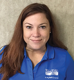
Serving as a state biologist for the Louisiana Department of Wildlife and Fisheries, Lisa was a member of the Marine Mammal and Sea Turtle Stranding Team. “We responded to reports of stranded dolphins and sea turtles across the Louisiana coast.
If the animals were alive, they worked with the Audubon Society to transport the animals to their rehabilitation center, and those that were deceased were collected for necropsy.
“Years after the Deepwater Horizon event, we were still working alongside federal and state partners to conduct marine mammal health assessments in Barataria Bay to assess the impacts of the oil spill on the local dolphin populations.” There were extremely long days and Landry says she will never forget the sights and smells she experienced working alongside the stranding team.
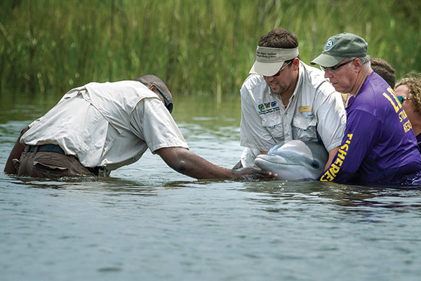
Releasing a dolphin back into the wild. Assessing the damage to marine mammals was a key component of Gulf Coast remediation. Photo: Audubon Nature Institute
At the end of her tenure with the state, Landry served as a member of the multiagency Restoration Planning Team tasked with developing restoration plans to offset the damages incurred from the Deepwater Horizon Disaster. “It was a rewarding job, and I truly learned a lot. Although I’ve since transitioned to a new role with Xylem, I still feel deeply invested in the future of the Gulf of Mexico, and I am very excited about the restoration projects taking place across the gulf coast.”
The Water Institute of the Gulf: Battling Wetland Loss in Coastal Louisiana
When The Water Institute of the Gulf (the Institute) was founded in 2011 in Baton Rouge, Louisiana, it set out a mission to provide independent research and technical expertise to ensure resilient coastal communities and sustainable water systems worldwide.
>>> Download Life After Horizon from Mission: Water Magazine
Created through a collaborative effort involving the State of Louisiana, Senator Mary Landrieu, and the Baton Rouge Area Foundation (BRAF), the Institute connects academic, public, and private research providers and conducts applied research to serve communities and industry. In all endeavors, the Institute’s goal is to increase understanding of natural and human aspects of deltaic, coastal, and water systems; to develop tools that apply knowledge to restore coasts and ecosystems, and to reduce the risk for people and infrastructure.
As stated by President and CEO Charles “Chip” Groat, Ph.D., the expert knowledge base being built today at the Institute is exportable. “Today, we are actively engaged in projects in other locations in the U.S. and around the world, including the Mekong River Delta and Latin America,” said Dr. Groat. “This initial portfolio of work is critical and will serve as a foundation for diverse future opportunities.”
However, located on the Mississippi River Delta, the Institute has to look no further than its home state to confront the harsh reality that wetlands are disappearing at an alarmingly swift rate – a phenomenon occurring across the globe.
At the rate of a football field disappearing every hour, land loss in Louisiana is more than local concern, it is a national dilemma. In addition to being called home by millions of residents, Louisiana’s coast and wetlands greatly support America’s energy industry and an interlaced port system that carries over 25% percent of all US waterborne commerce, and creates international business and trade opportunities.
The state’s wetlands house recreational and economically important fisheries – blue crabs, shrimp, oysters, menhaden, and more – comprising 25% of America’s seafood. Also, these wetlands provide the critical benefits of physical protection from storms and hurricanes. Unless restoration activities are successfully planned \ and implemented, land loss will continue to threaten, reduce, and eliminate these valuable assets and the communities they support.
To assist in restoration projects designed to restore and sustain lands in the delta and along the coast, the Louisiana Coastal Protection and Restoration Authority (CPRA) tasked the Institute with developing and applying a basin-wide integrated biophysical model. In order to create such a model, one that links water, sediment, and nutrient dynamics of the Mississippi River to complex processes of the estuary, an advanced set of tools and technology was needed.
For example, the Institute used many YSI multiparameter sondes in the estuaries of the Breton Sound and Barataria basins to collect water quality data such as salinity, temperature, turbidity, and oxygen.
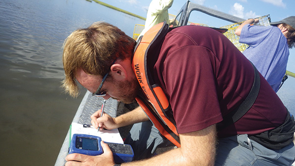
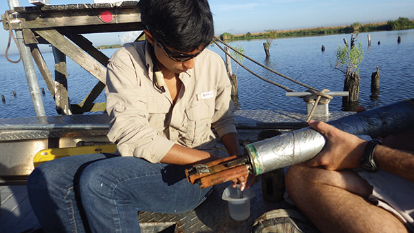
Leland Moss, research associate (top most image), records data for NOAA from a YSI EXO multiparameter sonde handheld. Cyndhia Ramatchandirane, research associate (above), performing maintenance on a YSI EXO sonde used for long-term monitoring. Photos: The Institute
This helped produce a calibrated and validated model capable of simulating critical coastal processes and predicting the effects on land change, vegetation, and nutrient dynamics resulting from proposed sediment diversions – engineered crevasses in the lower Mississippi River where riverine sediment is discharged into the basins to help build land. The model output findings were then used by CPRA to understand how different sediment diversions and their operations could slow down predicted wetland loss.
“The YSI multiparameter sonde was essential in collecting the varied hydrological data necessary for validating our decision support tool,” said Melissa Baustian, Ph.D. coprincipal investigator for this work and a coastal ecologist with the Institute. “The outputs of our integrated model have already been used by CPRA to decide which coastal restoration diversion projects they will pursue – that’s huge for the future of rebuilding Louisiana’s coast. The model continues to inform critical decisions on an ongoing basis.”
Through a cross-disciplinary approach, the Institute integrated links between data, models, and end users to continuously deliver high quality information to help sustain coastal Louisiana and its most valuable resources. As with its projects involving YSIs, the organization works to develop and apply tools that support effective and transparent decision making and that ensure livable communities and thriving economy and environment.
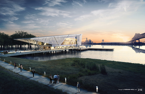
The Water Campus in Baton Rouge.
The Institute serves as the RESTORE Act Center of Excellence for Louisiana and will soon join CPRA and the Louisiana State University (LSU) Center for River Studies as the first tenants of The Water Campus in Baton Rouge, fostering an international destination for research, unprecedented views of the Mississippi River, and a collaborative culture to better understand and manage the complex relationship between water, land, and people.
Governmental agencies, business, and industry interests can thoughtfully plan for sustainable infrastructure, ecosystems, economies, and emergency preparedness by leveraging the Institute’s knowledge and capabilities, and the organization welcomes opportunities to apply its expertise with new partners to face new challenges.
>>> Download Life After Horizon to Learn More About our Gulf Coast Solutions and Meet our Gulf Coast Team
Dauphin Island Sea Lab: Water Heroes Interview with Renee Collini
About Dauphin Island Sea Lab
Founded in 1971 by the Alabama State Legislature, Dauphin Island Sea Lab (DISL) is the administrative home for Alabama’s Marine Environmental Sciences Consortium. Located on the eastern tip of Dauphin Island, a barrier island in the northern Gulf of Mexico, the DISL is surrounded by Mobile Bay, Mississippi Sound and the waters of the Gulf, making it a perfect location to conduct marine science activities. 
Renee's Role
Program Manager, Alabama Real-Time Coastal Observing System (ARCOS)
Coordinator, Northern Gulf of Mexico Sentinel Site Cooperative
Alma Mater
University of Texas at Dallas, B.S. Biology
University of South Alabama, M.S. Marine Science
Q. Tell us a little about Dauphin Island Sea Lab and your role within the organization.
A. Dauphin Island Sea Lab has been around since the early 70s, and in some rendition even before that. Our goal has always been to gain a deep understanding of our region’s marine and coastal environments, and to educate those in our communities about the importance of environmental stewardship and the impacts we all can have on our world.
>>> Download Life After Horizon from Mission: Water Magazine
In conjunction with research, education is a big mandate for our team, and we have a number of initiatives that include K-12 field programs, teacher-training, and public engagement. One of our most popular programs is the BayMobile, DISL's traveling classroom, which allows Sea Lab educators to bring marine science lessons to schools all across the region. My current role at the lab is to support our researchers with access to real-time water quality data and observations. It’s a program manager position that lets me take more of a leadership role on the team and ensures the valuable environmental data we’re collecting gets in the right hands.
Q. How long have you been with Dauphin Island Sea Lab?
A. I’ve been with DISL for several years and worked in a number of positions. I started out maintaining our network of water quality monitoring sites, collecting the data. These days I’m behind a desk, but I am doing equally important work securing funding for our work at the lab.
Q. Do you miss your days on the front lines as a technician?
A. (Laughter) That’s a tough one! The transition was difficult in some respects, but a breeze in others. The devil’s in the details when it comes to collecting high quality data, so it was challenging to pass the torch when I didn’t want to see anything overlooked. It was also difficult to let go of being out in the field day in and out. It’s just so beautiful out there…at least when it’s not freezing!
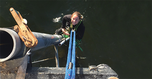
Field work offers its fair share of high adventure. Photo: Yantzee Hintz
But, I knew someone had to be a champion for our field work and support funding efforts for the organization. I had the experience to grasp both the importance of the data we collect and what it takes to make it happen.
Q. Why are the data collected by your team so important?
A. As an organization we continue to champion monitoring at a bigger scale. Continuous data inform EVERYTHING! Data help us make good policy decisions and also help us to relate environmental change to the general public. As environmental professionals, we are sentinels. We are the people watching and observing the world on a daily basis, and it’s our responsibility to understand ecosystem dynamics and to educate the people around us. Data help us do this.
Q. What are some of the challenges currently facing DISL?
A. Like most organizations right now, I’d say our biggest challenge is finding funds. Transitioning from grant to grant often times puts a lot of stress on the team.
It’s becoming difficult to get the money necessary for even basic ecosystem monitoring these days. It isn’t cheap to gather baseline data, but it’s absolutely critical to understand changes in our environment. You have to fight for every cent. Aside from funding, it’s balancing the needs of stakeholders, from restoration efforts to gulf-wide monitoring projects. Like all monitoring organizations, we have limited resources to go around. Everyone wants your time…for free. And while all these opportunities are worthwhile investments of our time, we have to prioritize. We can’t be everything to everyone, so we try to support as many folks as we can.
Q. What tips or tricks can you share for securing funding for monitoring efforts?
A. BE CREATIVE! As practitioners we inherently know the primary audience that would benefit from our data and often times we’ll target the same groups over and over again with requests for funding. This is the starting line, not the finish line. It’s not easy to break outside of our traditional sources, but we’ve had success looking at public health agencies, tying our water quality data to things like seafood safety. There are lots of public health opportunities where we can all benefit.
Another recommendation is to thoroughly understand your end users. You want to make sure you’re catching all the opportunities available to you and that starts by learning everything you can about the people using your data and educational services. Whenever my team makes field visits, we always introduce ourselves to the fishermen and tell them what we do. Whenever we go to a community meeting, we market our capabilities. Make use of every touch point to convey your value because you never know who’ll line up to support you next.
Q. The amount of effort required to collect a continuous data set is often under appreciated. How does your team pull it off?
A. You need dedicated people from top to bottom in an organization – and even then you have to battle. You need people who are driven to put in effort even in their spare time, on weekends. You have to be willing to stay up all night to deal with the problems that will inevitably arise, and you have to be enthusiastic about field trips in rain or incredibly hot weather.
Maintaining a high quality data record is a never-ending job. It requires a network of people to make it happen. Most folks don’t often think about that when they’re looking at the graphs and spreadsheets.
Q. Thanks for your time Renee!
Is there anything else you’d like to add?
A. Yes! I’d like to take this opportunity to thank all the marine field technicians that have helped DISL get to this point.
I’d also like to highlight our brilliant data manager, Lei Hu, who works her miracles to provide the general public with an amazing view of our local waterways at mymobilebay.com.
Lastly, I’d like to acknowledge Mike Dardeau! He built our network from the ground up and gave myself and all the other members of the team the opportunity to do this fun and important work. (And my Mom! She strong-armed me into taking a NSF research experience at DISL and it’s turned out to be one of the best experiences of my life. Love you Mom!).
