Water Level Monitoring and Measurement

Water Level

What Is Water Level, and Why Is It Measured?

Water level is one of the most commonly measured parameters, as accurate level data are essential for many applications. While climate change, pollution monitoring, and industrial water usage are broad reasons for monitoring water levels, more specific applications are discussed throughout this page.

Level is perceived as one of the most straightforward water parameters. In general, it is the level of water in a body of water, in groundwater, in a tank, etc. However, there’s a lot to unpack with this parameter. Not only are there very different water level applications and technologies used to measure it, but there are also a variety of terms used when describing water level, some of which have only subtle differences. These include:

  • Water level: The height or elevation of water above (more common) or below (less common) a user-specified point. This term is used in many applications.
  • Depth: When measuring in a groundwater well, this is the distance from the land surface to water in the well. In surface water, depth is the distance from the water’s surface to a specific point, typically the bottom of the water body or the location of a sensor.
  • Gage height: Used to describe the water level of a river or stream. Level measurements in these applications are often collected at streamgage stations.
  • Tide Gage: Describes a water level sensor used to monitor changes in sea level.
  • Elevation: Used when describing the height of water above sea level.
  • Hydraulic head: The height to which a column of water is above a reference elevation (e.g., sea level). Like elevation, this term is often used in groundwater applications.
Water Level
Water level might be the most important – and certainly the most widespread – parameter measured today. Accurate water level measurements are needed in many applications.

Why Measure Water Level in Rivers and Streams?

Gage (gauge) height, sometimes referred to as stage, is the water level of a river or stream. Gage height changes due to precipitation (or lack thereof), snowmelt, and water management decisions.

A common reason to gather gage height data is to establish a baseline profile. These data are helpful to engineers that are designing structures such as bridges or levees. Additionally, ecologists can use baseline data when studying aquatic habitats and environmental impacts.

Real-time gage height data can indicate when river levels are beginning to exceed the baseline, providing the local community an early warning of dangerous flood conditions.

During Hurricane Harvey in 2017, data from an Amazon Bubbler allowed local authorities to monitor the impact of an incredible amount of rainfall – over 127 cm (50 inches) in less than four days – on local waterways. Read more about this story in Mission: Water, our magazine that addresses global water issues. If you’re interested in flood monitoring systems, check out our Stormwater Solutions Brochure or Stormwater page.

Water Level Monitoring Flood
Heavy rain from Hurricane Harvey caused rivers and streams to swell, resulting in devastating flooding in the region. Level sensors allowed local authorities to monitor this flooding in real-time.

Flood inundation maps reveal areas that will be flooded – and how deep those floodwaters will be – at different stream stages (i.e., water levels). Created using modeling tools that are more accurate than historical flood observations, these maps allow for easy visualization of flooding impacts. When coupled with real-time gage height data and flood forecasts from the National Weather Service, areas at risk of flooding can be identified.1

Water Level
Streams in arid regions can rise quickly after large storms, and water level monitoring systems can alert local authorities to these changes.

Those who use the river for recreation – kayakers, anglers, and others – often need real-time gage height data to ensure the river level is safe and appropriate for their activity. The United States Geological Survey (USGS) supports the collection of water level data at approximately 10,000 locations in the United States.2 Data from these stations – termed streamgage stations – can be viewed on the USGS National Water Dashboard. Local cities and counties may also have a website with stage data, such as the Charlotte-Mecklenburg Flood Information & Notification System.

What is a Streamgage?

Gage height is the most fundamental measurement captured at a streamgage station, a crucial piece of infrastructure for the long-term monitoring of surface water flows. These stations are often located in remote locations and provide end-users with reliable real-time data for decision making.

Water Level Streamgage Height Data
The United States Geological Survey (USGS) operates an extensive network of streamgage stations throughout the U.S. The data in this figure are from a station located on the Merced River in Yosemite National Park (USGS Site 11264500). Diurnal fluctuations of gage height at this site can be observed in the spring as snowpack melts during the day.

Modern streamgaging stations often feature a water level instrument – see the How to Measure Water Level section – and a datalogger, such as the YSI H-522+ or Storm 3. The datalogger will contain an internal radio or cellular modem to transmit data to a database like the one managed by the USGS for their National Water Dashboard.

Gage height data can be used as the starting point for calculating discharge, although the method for doing so can vary from site to site. Often, a calibrated structure is already in place that controls water flow, such as a flume or weir. Flumes are specifically shaped structures – some are even prefabricated – that water flows through. A weir, sometimes called a low head dam, is often made from concrete or steel that stretches across an open channel.3 If a flume or weir is present, water level data is used to calculate discharge.

To develop and verify the relationship between water level and discharge at gaging sites, hydrologists use tools like the SonTek RiverSurveyor M9, RS5, or the FlowTracker2 to obtain high resolution, high accuracy measurements of discharge for a given point in time.

Water Level Streamgage Datalogger
This image shows one of two continuous flow measurement stations in the San Jacinto-Brazos and the Brazos-Colorado Coastal Basins. Streamgage stations like these are typically equipped with at least a water level sensor and a datalogger, although other instruments (e.g., a water quality sonde) are often present. Read more about these particular stations in issue #4 of Mission: Water.

Besides a water level sensor, discharge instrument (if necessary), and a datalogger, modern streamgaging stations are often equipped with instruments that measure water quality, such as the YSI EXO sonde. For researchers aiming to obtain a comprehensive perspective on environmental phenomena, collecting water quality and level/discharge data is crucial to understanding what environmental and man-made influences impact a body of water. Check out our webinar on Why Collect Water Quality Data When All You Need is Flow (or Vise Versa!) to learn more.

Level sensors, and other water level indicators, can also be coupled with meteorology instrumentation like a rain gauge (e.g., the Model H-3401), as they can help predict when flooding may occur.

Why Measure Level in Reservoirs, Lakes, and Ponds?

Establishing a baseline of water level is also crucial for ponds, lakes, and reservoirs, as these data indicate when the volume of water is unusually low or high.

Monitoring the water level in lakes and reservoirs is especially important, as they often serve as the source of drinking and irrigation water in many communities. In addition, these surface water bodies can generate electricity via a dam, help control floods, serve as a place for recreation, and as a habitat for wildlife.

Lake Mead – located in Nevada and Arizona – is a large reservoir formed by the Hoover Dam. It is America’s first and largest national recreation area and provides drinking water to over 25 million people.4 The Hoover Dam generates enough electricity to serve the needs of nearly 8 million people in Arizona, southern California, and southern Nevada.5

Water Level Lake Mead
The “bathtub ring” indicates where water levels in Lake Mead used to be. In June 2021, water levels in the lake were 140 feet below what the U.S. Bureau of Reclamation defines as “full”.6

Water levels in Lake Mead began dropping steadily around the year 2000, resulting in record-low water levels by 2021. Exceptional drought and extreme heat have driven this decrease in water level to a critical point.6 This unfortunate situation not only threatens the water supply of millions, but it has also resulted in a reduction in the amount of power generated by the Hoover Dam – about 25% less in 2021 versus typical power output.7

The situation at Lake Mead – and many other reservoirs around the world – demonstrate that water levels in reservoirs and lakes can become dangerously low when precipitation shortfalls coupled with high temperatures lead to drought conditions. This can ultimately result in intense competition for water and painful restrictions on water use.

Monitoring the water level in a pond – especially in an artificial pond – can help indicate potential problems with its design. Water will evaporate from a pond, especially during the summer. However, if the water level drops more than expected, a leak is often the cause; these can be expensive to fix.8

Low pond and lake levels are especially problematic for aquaculture operations, as dissolved oxygen (D.O.) levels often decrease while predation and disease increase whenever water level drops.9

Why Measure Water Level in Wetlands?

Water level is an essential parameter to monitor in a wetland, as plants are sensitive to oxygen concentrations in the soil. Wetlands with high water levels typically have lower soil dissolved oxygen (D.O.) concentrations, while wetlands with low water levels have higher soil D.O. concentrations. Water levels can change in wetlands throughout the year – some are permanently flooded, others have periods of being completely dry.10 Check out our dissolved oxygen page to learn more about this parameter.

Water Level Measurement
Water level plays a significant role in the regulation of dissolved oxygen in wetland soil. The image here is of a wetland in Great Basin National Park in Nevada.

Regulating water levels in restored wetlands through water control structures (e.g., levees and spillways) is an essential part of land management.11 According to the USDA, restored wetlands should have an average depth of 18 inches, although this can vary based on the landowner’s goals.

Why Measure Water Level Along Coasts?

One of the most severe consequences of climate change for coastal communities is sea-level rise. This increase in sea level is measured with level sensors – termed tide gauges when used in this application. As is mentioned in our blog post on Surging Seas at Dry Tortugas National Park, a tide gauge operating on Key West since 1913 has recorded an average of 2.36 mm of rise per year – a total of more than 9 inches! This rate of sea-level rise is only expected to accelerate.12

Sea Level
Dry Tortugas National Park is 70 miles west of Key West, Florida. A tide gauge operating on Key West since 1913 has recorded an average of 2.36 mm of sea-level rise per year.12

Other impacts of climate change on the coast include changing weather patterns, possibly leading to stronger and more frequent hurricanes. Storm surge and large waves pose the greatest threat to life and property in coastal communities during these weather events.13 Check out our interview with Dr. Philip Klotzbach, a world-renowned hurricane forecaster!

Flooding in coastal communities during significant storm events – which is made worse with sea-level rise – has prompted coastal communities to more closely monitor water levels. This includes roadway monitoring systems that combine water level sensors and telemetry for a real-time alert system. The alerts can be directed at city managers, news stations, and mobile apps that drivers can access directly from their phones. Read more about these systems in On the Level | Flood Monitoring for Coastal Resilience and our story on an innovative flood control project in Terrebonne Parish, Louisiana.

Why Measure Groundwater Level?

Monitoring groundwater levels is essential for several reasons, including understanding how groundwater pumping impacts the availability of groundwater in aquifers and the amount of water present in surface water bodies that interact with groundwater.

Groundwater Levels
An aquifer is a geological formation that stores and/or transmits water.14 This water can be extracted via a well. Excessive groundwater withdraw can result in the well going dry.

Groundwater Extraction from Pumping

Pumping groundwater – for agricultural, domestic, and industrial use – can significantly affect the amount of groundwater stored in an aquifer.

Monitoring groundwater levels in aquifers used as a water supply can help minimize undesirable results if too much groundwater is extracted via pumping. If excessive groundwater is extracted, wells can go dry, resulting in the need to deepen the well, drill a new well, or attempt to lower the pump – all of these can be prohibitively expensive.

Excessive pumping can also cause low-quality water to move into the aquifer. In coastal freshwater aquifers, saltwater intrusion can occur when the different densities of saltwater and freshwater allow ocean water to intrude into the aquifer.

Land subsidence is another potential impact of excessive groundwater pumping. When the water that fills the aquifer’s pores is removed, the sediment compacts, resulting in cracks in foundations, walls, roads, or the formation of sinkholes.

Surface Water Interaction

Water flowing in rivers can originate from the seepage of groundwater into the streambed; the amount varies based on a region’s geography, geology, and climate. Consistently monitoring groundwater elevations can help determine the contribution of groundwater to local lakes, streams, and rivers.

During droughts, groundwater contribution to the streamflow becomes especially important. Not only is the aquifer contributing a more significant percentage to streamflows during these periods, but groundwater levels typically fall as more groundwater is pumped to meet water demands. This demonstrates that changes in groundwater levels can sometimes be linked to climate change.

Why Measure Level in Wastewater and Water Treatment?

Water level is an essential measurement in wastewater and drinking water facilities when monitoring and managing water flow. In combination with a weir or flume, level sensors are used to calculate flow at various points in the wastewater treatment process, particularly at the influent and effluent of the facility. Drinking water facilities often use level sensors to monitor their source water, various filtration processes, or water tanks. Additional applications in the water and wastewater industry include chemical tank monitoring, lift stations, digesters, and more.

Float Switch Water Level
Float switches like the MJK 7030 indicate when the water level has risen or fallen to a specific point, often triggering pumps or alarms.

Level data collected in wastewater and water treatment facilities are often used to trigger pumps and alarms. Operators can also adjust their processes based on the level and flow data acquired from these sensors.

Why Measure Level in Industry?

Measuring water level is also relevant in some industries. For example, stormwater runoff from oil refineries can contain dangerous chemicals. As a result, refineries must manage their stormwater runoff, and many of them have stormwater NPDES permit they must adhere to.

Water Level Stormwater
Industrial facilities like oil refineries must monitor their stormwater runoff to ensure harmful chemicals from the site don’t end up in water bodies. Part of this required monitoring may involve measuring the level of runoff in a stormwater channel that leads into receiving waters.

Compliance with an NPDES discharge permit is sometimes achieved by continuously monitoring flow into the receiving waters, and water level is part of this measurement.

Our blog On the Level | Stormwater Monitoring for a Refinery’s NPDES Permit discusses how a refinery in Texas wanted to take a proactive stance on their NPDES stormwater permit. It also reviews the system we designed that centered on the SonTek-IQ to capture volumetric flow information.

Similar to wastewater and water treatment facilities, industrial facilities often have large holding tanks. Measuring the level inside these tanks allow managers and operators know how much water or chemical is available for their processes.

How to Measure Water Level

There are two main types of water level indicators – contact and non-contact. Contact sensors are placed in the water when measuring water level. In contrast, non-contact sensors use a measurement method (e.g., emission of microwave impulses or ultrasonic sound waves) that does not require any instrument components to be placed in the water.

Contact Water Level Sensors

These types of sensors have been around the longest. There is a wide range of contact sensors – from incredibly simple to high-tech – and some are designed for specific applications.

Crest Stage Gages

A crest-stage gage is a simple way to measure water level, most often in streams and rivers. These gages consist of a metal pipe, wood staff, and a cork that’s been crushed up. Unlike modern level sensors, the crest-stage gage can only record the maximum water level. They are typically ‘reset’ before a high-water event occurs and checked by a technician after the event is over or when the water level has stopped rising.15

Water enters through holes in the bottom of the pipe. It rises in the pipe, with the cork floating on top. Once the level stops rising, the cork sticks to the wood staff, and it stays there while the water recedes.15

Crest Stage Gage
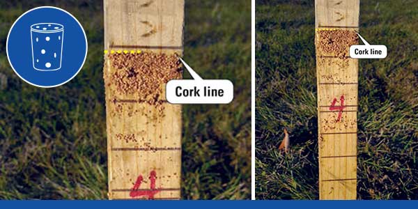
Crest-Stage gages use crushed cork and a wood staff to record the maximum water level.15

Besides only being useful during high-water events, there are several potential issues with the design of a crest-stage gage:

  • The holes in the bottom of the metal pipe can become clogged.
  • Ants can build nests on the cork, thus preventing it from rising once a flood occurs.
  • The cork can get washed out of the vent hole.

Staff Gages

A staff gage provides a visual indication of the current water level. It looks like a ruler and is attached to a static structure, such as a bridge. The gage can be installed vertically or flush with the streambank on an incline, as this helps prevent damage.16 Staff gages are one of the most common reference sensors used when calibrating electronic level sensors.

Staff gages are appropriate for water level measurement in nearly any application (e.g., rivers, reservoirs, wetlands). They do have limitations, as there’s no way to monitor staff gages remotely – someone has to be on-site collecting data.

staff gage water level measurement
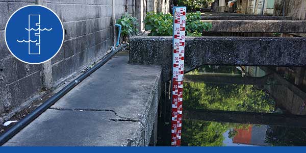
Staff gages look like giant rulers that are used to measure water level. This image is from a canal in Din Daeng District, Bangkok, Thailand. Staff gages are one of the most basic water level indicators in use today.

Wire-Weight Gages

There are different flavors of wire-weight gages, but they all operate similarly. Wire-weight gages are placed over a body of water and are often attached to a bridge handrail. They consist of a drum wound with a cable that has a weight at the end. The technician lowers the weight to the surface of the water using a crank. A counter is part of the gage, and it is what determines how far the weight has been lowered. Once the technician has recorded a reading, they crank the cable back up from the water's surface.16 Like staff gages, wire-weight gages are often used as a reference when calibrating electronic level sensors.

water level measurement wire weight gage
Wire-weight gages are often attached to a bridge. The technician lowers the weight to the water's surface to get a level measurement. This image is from the USGS manual on Stage Measurement at Gaging Stations.

Wire-weight gages have a simple design, but they can be challenging to use. In turbulent conditions, multiple readings will be needed to determine the water level. If the water is still, it can be difficult to tell when the weight is touching the water.16 Like crest-stage and staff gages, wire-weight gages require a technician to visit the site and record measurements.

Sounders

Electric water level meters – referred to as sounders – are frequently used in groundwater to measure level. These instruments are essentially tape measures with a probe on the end. Once the sensor contacts the water, it completes a circuit, causing an indicator to beep and an LED to glow. The water level depth can then be read on the tape.

water level meter
The WL500 Water Level Sounder uses a robust NTS-certified polyethylene jacketed measuring tape that will accurately read to 0.01 foot or 1 mm. When the sounder's water level probe assembly makes contact with the water's surface, a bright LED glows and a beeper sounds.

The WL550 Oil Water Interface Meter is a great option when investigating the depth and thickness of hydrocarbons in groundwater. This includes light non-aqueous phase liquids (LNAPLs) that are lighter than water (i.e., they float on top of the water) or dense non-aqueous phase liquids (DNAPLs) that sink. Hydrocarbon contamination can be dangerous to the water supply, so environmental scientists use meters like the WL550 to identify the location of contamination and react accordingly.

The WL550 works differently from the WL500, as the oil-water interface probe uses infra-red refraction to detect hydrocarbons and conductivity to detect water. Like the WL500, the WL550 makes a sound when the probe contacts the measurement solution.

Sounders are easy to use and relatively inexpensive. However, like the devices already mentioned, they require a technician to visit the site to take the measurement; these are not meant to collect continuous data like options such as Submersible Pressure Transducers or Bubblers .

Float Switches

A float switch – sometimes referred to as a level switch – indicates when the water level has risen or fallen to a specific point. These level sensors are most commonly used inside tanks at wastewater facilities and often trigger pumps or alarms. Because they are often deployed in harsh environments, float switches are constructed with rugged materials such as polypropylene.

All Xylem float switches operate on the same basic principle – any change in position causes the sensor to activate. Examples of float switches from Xylem include the MJK Float Switch 7030.

float switch water level
Float switches such as the MJK 7030 are ideal for determining level in different types of tanks, including those at wastewater facilities.

Shaft Encoders

Shaft encoders are used to measure level in a stilling well as part of a streamgage station, hydrometeorological site, or flood warning system. However, they are also sometimes used in groundwater wells.

Stilling wells are large vertical structures with a hollow center – many look like a giant tube – and are often installed along a riverbank. Water enters through pipes at the bottom of the well; this allows the water level in the well to be the same as that of the river.17 This design protects instrumentation inside the well and mitigates the impact of wind and turbulence on water level.16

shaft encoder water level
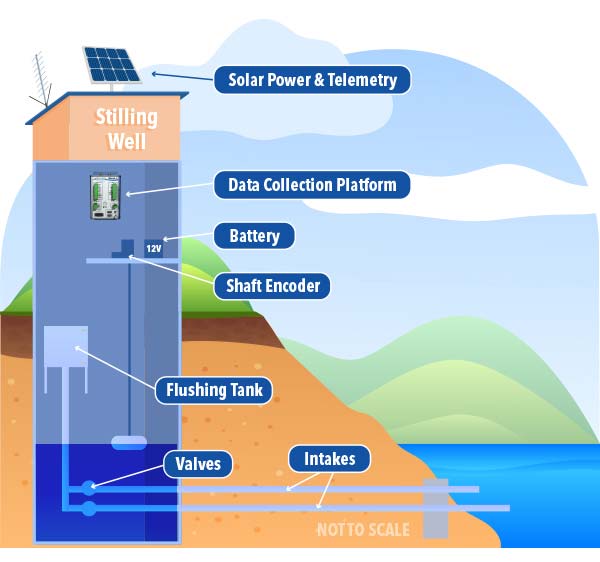
Shaft encoders must be installed in a stilling well. Despite having a relatively simple design, shaft encoders can transmit real-time data when coupled with a datalogger and data transmitter. This graphic is adapted from an image in the USGS manual on Stage Measurement at Gaging Stations.

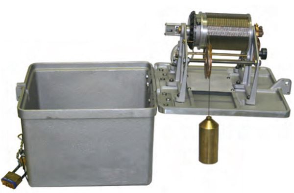
The YSI Shaft Encoder features a box with an internal microprocessor-controlled digital counter, a shaft, a pulley, and a weight with a float that hangs from the pulley. As the water level changes, the encoder’s shaft rotates. This change in position is translated into a change in level by the shaft encoder.

Shaft encoders are simple, accurate, reliable, and inexpensive. However, they must be installed inside a stilling well. Not only is a stilling well expensive and time-consuming to install, but they also have maintenance requirements and can be unsafe for those that need to service them.

Submersible Pressure Transducers

Submersible pressure transducers measure level by calculating the pressure exerted on them from the water column above – the more water above the sensor, the greater the pressure. Pressure is then converted to either feet or meters.

Another source of pressure picked up by the sensor is the pressure exerted by the atmosphere upon the water’s surface. Therefore, barometric pressure is a significant variable to consider when using pressure transducers. In general, there are two types of submersible pressure transducers – absolute and differential – that differ in how they handle barometric pressure compensation.

So, how are absolute and differential level sensors different? Differential pressure transducers are vented to the air via a vent tube, allowing the overall measurement to be compensated for barometric pressure. Examples of differential sensors include the WL16, WL450 & H-3123 pressure transducers, and the EXO1/EXO2 multiparameter sondes with the vented option. The WL430 is an excellent option for challenging environments like wastewater sludge, lift/pump station sewage level, wet wells, and slurry tanks.

pressure transducer
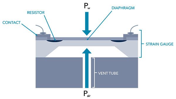
Differential sensors are vented to the air via a vent tube. This enables the overall measurement to be automatically compensated for barometric pressure.

In contrast, absolute pressure transducers are not vented, so the pressure reading from the transducer reflects both the barometric pressure and the pressure attributed to the water column above it. Data can be adjusted to remove the influence of barometric pressure if an external barometric pressure sensor is used, but this requires additional steps. This also decreases the overall accuracy, as the error attributed to both the water level sensor and barometric pressure sensor are present in the final measurement.

Examples of absolute pressure transducers (i.e., non-vented sensors) include the EXO1/EXO2 multiparameter sondes without the vented option. The ProDSS and ProSwap systems with an optional depth sensor are unique, as they measure virtual vented depth. The virtual vented depth measurement allows for real-time compensation for atmospheric pressure using the handheld’s built-in barometer.

non vented water level
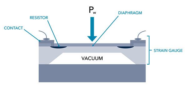
Diagram of a non-vented pressure transducer, also called absolute pressure transducers. One side of the sensor’s diaphragm is exposed to the water – where pressure changes – and the other side is exposed to a vacuum – where pressure is constant.

Check out our blog on Groundwater Measurements at High Altitude to learn more about these types of level sensors and the impact of barometric pressure on level data.

Submersible pressure transducers can be used in a variety of applications, although they are most often used in groundwater. They are typically used in conjunction with a datalogger and a telemetry device when continuously monitoring water levels.

streamgage station pressure transducer
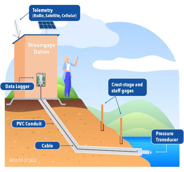
When submersible pressure transducers are used in surface water applications, they are often coupled with another water level indicator that serves as a reference gage; a staff gage is commonly used.
submersible pressure transducer measuring water level
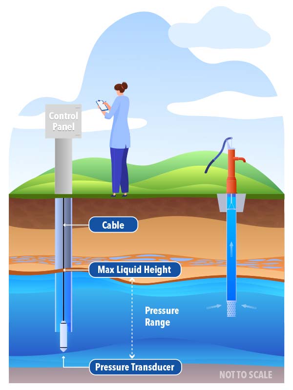
Submersible pressure transducers are commonly used in groundwater applications. This image shows how the level sensor is placed in a well.

Submersible pressure transducers are easy to use. However, the sensing portion of the instrument – electronics included – is placed in the water, so they have a shorter lifespan than some other sensors (e.g., Bubbler or Radar). Also, pressure transducers can become clogged or damaged by debris in the water column are not the best choice when the water is turbulent.

Bubblers

Bubblers feature pressure sensors that are not placed in the water. However, they are still considered contact sensors, as part of the instrument – the orifice line (e.g., a plastic tube) – is placed in the stream.

Instruments like the Amazon Bubbler operate by continuously forcing air from the instrument housing through the orifice line. A pressure sensor in the instrument housing records the pressure required to push the air out of the line, while an onboard barometer automatically compensates measurements for barometric pressure.

water level bubbler
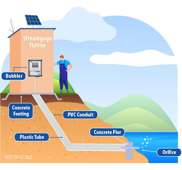
A bubbler can be used to determine gage height. The instrument housing is placed in an enclosure (e.g., a streamgage station). The orifice line is fed through a conduit, and it goes from the instrument to the water. The end of the orifice line must be secured in place to ensure accurate data is collected.

Bubblers are accurate and can be used in a variety of applications, although they are most often used in surface water. The sensor is not placed in the water column, thus reducing the risk of premature sensor failure and damage to the sensor from debris. Therefore, bubblers tend to last longer than submersible pressure transducers. There are very few drawbacks to bubblers, one of which is the potential for the orifice line to become clogged.

water monitoring station level sensors
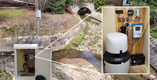
A continuous water monitoring station could include a bubbler water level sensor such as the Amazon Bubbler, EXO multiparameter water quality sonde, Storm 3 Datalogger, and ProSample sampler. Read more about a setup like this in our application note on Determining the Source of Stream Toxins.
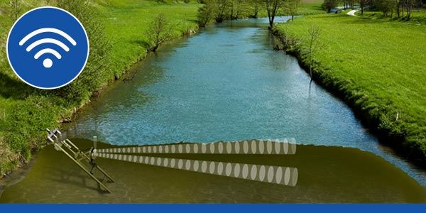
Acoustic Sensors

Instruments like the SonTek-IQ and SonTek-SL use an acoustic beam to measure water level. The beam sends a short pulse and waits for a reflection from the water’s surface. The instrument converts the reflection time to level based on the speed of sound in the water at the site; this depends on temperature (measured with an integrated sensor) and salinity (user-defined).

While the beam is the primary measurement method, an onboard pressure sensor serves as a secondary measurement in the event valid data from the acoustic beam cannot be collected. The pressure sensor is not vented to the atmosphere; therefore, it must be calibrated for changes in atmospheric conditions.

acoustic water level sensor
In this image, a SonTek-IQ measures velocity and stage in an open channel in Italy.
monitoring water level
The SonTek-SL, affectionately known as the Side-Looker or "S.L.," is designed specifically for side mounting on bridges, canal walls, or riverbanks.

The main advantage of instruments like the SonTek-IQ and SonTek-SL is they measure velocity in addition to level. The SonTek-IQ is ideal for monitoring flows in canals, culverts, pipes, and natural streams. The SonTek-SL is designed for side mounting on bridges, canal walls, or riverbanks, making it ideal for coastal areas, ports, rivers, and irrigation.

The primary disadvantage to acoustic instruments is cost; these are the most expensive type of level instruments. Also, they are susceptible to fouling covering the sensing surfaces and can be complex to maintain. Thus for the purpose of measuring level alone, acoustic sensors might not be the best choice. But if level is the secondary aim and flow is a priority, these sensors can't be beat.

Non-Contact Water Level Sensors

Non-contact sensors have an advantage over contact sensors in some applications. They can be used when water may not always be present – bubblers can also be used in such an application – or when the sensor cannot be placed in the water due to other hazards. This also makes non-contact sensors safer for those that maintain them. Another advantage is there’s no concern of sensor damage due to debris and flood conditions. It is for these reasons that many professionals prefer non-contact sensors.

It should be noted that non-contact sensors are susceptible to vandalism and damage from wind/severe weather events. They also need to be calibrated to measure the water level accurately and to eliminate interferences.

Radar Sensors

Radar water level sensors like the YSI Nile Radar and the WL900 Radar Level Transmitter are “downward-looking” measuring systems that operate based on the time-of-flight method (ToF). They are typically attached to structures like bridges. Microwave impulses are emitted by an antenna, reflected off the target (water surface), and received by the radar system. Radars are popular because they provide stable, long-term monitoring with high accuracy and a low cost to service and operate.

Radar Sensor Water Level Monitoring
The YSI Nile Radar is a non-contact sensor that uses microwave impulses emitted by an antenna. The instrument measures the amount of time required for the impulses to be received by the radar system after reflecting off the water's surface.

As previously mentioned, non-contact sensors need to be configured to eliminate interferences. With the YSI Nile Radar, built-in technology allows users to map out interferences like rocks or bridge piers.

Ultrasonic Sensors

Ultrasonic sensors are similar to radars, as both sensors are typically installed above the water’s surface. However, ultrasonic sensors use ultrasonic sound waves – these require a medium to pass through, unlike microwaves – to determine the distance from the face of the sensor to the surface of the water by timing how long it takes the signal to return.

The WL705 Ultrasonic Water Level Sensor sends out a soundwave of a frequency greater than 20,000 Hz. This signal spreads outward with a 12° beam angle, and objects in the path of the beam will interfere with the signal return. This type of sensor is suitable for various applications, including measuring river, lake, and tank levels and measuring open channel flow in larger flumes.

The WL650 Sonic Water Level Meter is a bit different, as it is specifically designed for measuring in groundwater wells. The signal is injected from the meter duct into the well casing. It travels down the well bouncing off the well casing, and is reflected from the water surface back to the meter microphone.

How to Select the RIght Water Level Sensor

There are five questions to consider when selecting a water level sensor:

1. Do I need a non-contact sensor?

There are two main types of water level sensors – contact and non-contact. Contact sensors are placed in the water when measuring level, while non-contact sensors are not. This is the most logical place to begin identifying the ideal sensor for you.

Some customers strongly prefer non-contact sensors because the measurement solution (e.g., the river, chemicals in a tank, etc.) doesn’t contact the sensor; therefore, the technician does not need to come in contact with the solution. For many, this means non-contact sensors are a safer option, which is why so many customers prefer them.

While a non-contact sensor sounds like a great option, they aren’t for everyone. As you’ll see, these sensors can be expensive – keep reading!

2. Do I need continuous data?

Another significant consideration is how data will be recorded. Crest-stage gages, staff gages, and wire-weight gages require that someone physically visit the site to record a data point. This requirement is too burdensome for many end-users, and in many instances, real-time data is needed.

Other instruments provide continuous real-time data since they measure regardless of whether someone is present or not. Data collected by the instrument can be transmitted to a database such as the HydroSphere cloud data hosting service. Authorities can view this real-time data and respond to events (e.g., flooding) quickly and appropriately. Those who use a river for recreation – kayakers, anglers, and others – also often need real-time gage height data to ensure the river level is safe and appropriate for their activity. These are just a few instances where continuous real-time data are essential.

3. What application will the sensor be used in?

Sensor suitability in different applications was discussed in the preceding sections, so the table below summarizes the ideal applications in which each of our level sensors can be used.

Ideal Fit

Suitable, but not ideal

Not recommended

Sensor Example Xylem Product(s) Rivers/Streams/Channels Reservoirs/Lakes/Ponds Coasts Groundwater Wastewater/Water Treatment
Crest-Stage Gages None
Staff Gages None
Wire-Weight Gages None
Sounders WL500
WL550
Float Switches MJK 7030
Shaft Encoders YSI Shaft Encoder
Submersible Pressure Transducers WL16 (vented)
WL430 (vented)
WL450 (vented)
H-3123 (vented)
ProSwap (virtual vented)
ProDSS (virtual vented)
EXO1 (vented option)
EXO2 (vented option)
WL430 only
Bubblers Amazon
Acoustic Sensors SonTek-IQ
SonTek-SL
Radar Nile
Ultrasonic Sensors WL650
WL705

* Industry - depends on the specific application. Please contact YSI to discuss your options

4. What other parameters do I need to measure?

There are some sensor options in the table above that measure much more than water level. The EXO, ProDSS, and ProSwap all measure various water quality parameters. In addition, the EXO is ideal for long-term, continuous monitoring.

The SonTek-IQ and SonTek-SL measure more than level – they also measure velocity, and they do it very well! The SonTek-IQ is ideal for monitoring flows in canals, culverts, pipes, and natural streams. The SonTek-SL is designed for side mounting on bridges, canal walls, or riverbanks, making it ideal for coastal areas, ports, rivers, and irrigation.

5. What's my budget?

Last but not least is the cost of each sensor. The table below provides a general idea of the cost of various Xylem level sensors, ranging from less than $1,000 to over $10,000. While we don’t offer crest-stage, staff, or wire-weight gages, it’s fair to assume these are not overly expensive options.

Sensor Example Xylem Product(s) Expected Price
Sounders WL500
WL550
$ to $$
Float Switches MJK 7030 $ to $$
Submersible Pressure Transducers – Single Sensors WL16 (vented)
WL430 (vented)
WL450 (vented)
H-3123 (vented)
$ to $$
Shaft Encoders YSI Shaft Encoder $$
Ultrasonic Sensors WL650
WL705
$$
Bubblers Amazon $$$
Radar Sensors Nile $$$
Submersible Pressure Transducers – Integrated into Multiparameter Instruments ProSwap (virtual vented)
ProDSS (virtual vented)
EXO1 (vented option)
EXO2 (vented option)
$$$ to $$$$
Acoustic Sensors SonTek-IQ
SonTek-SL
$$$$*

* The SonTek-IQ and SonTek-SL measure velocity in addition to level.

Still not sure which level sensor is right for your needs? Ask our experts or schedule a free virtual consultation today!

Sources

  1. USGS, Flood Inundation Mapping Science
  2. USGS, Streamgaging Network
  3. Utah Division of Water Rights, Flow Measurement Devices
  4. National Park Service, Lake Mead | Water Quality
  5. Arizona Power Authority, History of Hoover
  6. The Washington Post, Lake Mead reaches lowest level on record amid exceptional drought
  7. azcentral, Hoover Dam, symbol of the modern West, faces a new test with an epic water shortage
  8. Kansas State University, Leaking Farm Ponds
  9. The Fish Site, Fish farmers hit hard by drought on Lake Kariba
  10. EPA, Methods for Evaluating Wetland Condition | Wetland Hydrology
  11. University of Minnesota, Water Control Structures Used in the Restoration and Creation of Wetlands
  12. National Park Service, Keeping watch on Surging Seas
  13. NOAA, Hurricane Preparedness - Hazards
  14. USGS, Local aquifer description
  15. USGS, Crest Gage: A Quick Way to Measure River Stage
  16. USGS, Stage Measurement at Gaging Stations
  17. USGS, Stilling wells have been used historically to measure river stage