Groundwater Measurements At High Altitude
What parameters come to mind if you are asked what it means to monitor water quality? The “Big 5” parameters of temperature, conductivity, pH, dissolved oxygen, and turbidity? Chlorophyll and phycocyanin for tracking harmful algal blooms? In my experience as a manager of water quality instrumentation, “water level” is rarely the first answer I get when I ask this question. In fact, in some circles, water level is not considered a measurement of water quality at all, but rather of water quantity, and it is treated like a completely independent topic.
Whether you believe it is a water quality parameter or not, water level might be the most important, and certainly the most widespread, parameter measured today. Accurate water level measurements are important for groundwater monitoring, stream and river gauging, lake/pond level analysis, flood level recording, irrigation canals, wave and tidal analysis…the list goes on and on! I recently blogged about my recommitment to climate change education, and water level is highly relevant in that context, too. As climate change drives extreme weather events, communities deal with stormwater and floods, drought and water scarcity, sea level rise, and other climate-related issues.
This is the first of a series of blogs that will highlight three projects where my Xylem colleagues have made water level measurements for very important applications:
- Groundwater monitoring,
- Stormwater monitoring,
- Flood monitoring.
As you will see, the work they are doing raises important considerations when choosing the right technology and methods for monitoring water level.
Groundwater Monitoring
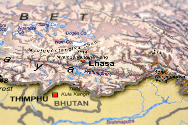
The first example comes from my colleague James Chen, who works out of our Xylem Analytics Beijing office. James is a veteran water monitoring specialist, serving YSI in everything from field applications to sales and business development, and he has worked in some of the most fascinating places on Earth! Case in point, James has a project in Lhasa, Tibet where groundwater is being monitored.

It is important to monitor groundwater levels for several reasons, including understanding aquifer levels under static conditions and pumping conditions, determining how the levels interact with local surface water sources, and understanding how surface development has impacted the aquifer. In this particular case, the client James helps is responsible for monitoring natural resources in Lhasa, and especially water quality, since Lhasa is considered the Water Tower of Asia.
James approached this task with an EXO1 vented level sonde. This instrument choice demonstrates at least two very important principles about groundwater monitoring. First, it demonstrates that water quality monitoring, in the classical sense, is also a priority. Why is this client measuring water quality parameters like specific conductance, temperature, pH/ORP, and turbidity, rather than just measuring groundwater level?
The main reason is that just because water levels might be abundant doesn’t mean a source is suitable for drinking. Rainwater or surface water can come into contact with contaminated soil while seeping into the ground, from that point it can become polluted and carry the pollution from the soil to the groundwater aquifers. Groundwater can also become contaminated when liquid hazardous substances soak down through the soil or rock into the groundwater. There are a number of other types of point and non-point source pollutants of groundwater, and at this site, the client needed to monitor for such threats.
Continuously monitoring for changes in standard water quality parameters is an excellent way to do this, and demonstrates a key advantage of using the narrow-diameter EXO1 sonde rather than just a level logger for groundwater monitoring.
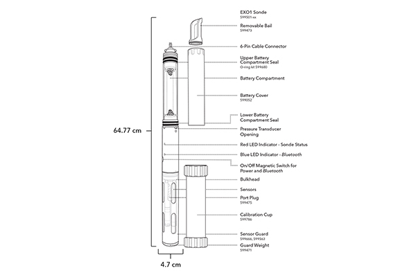
The second principle that this project demonstrates is the importance of using a vented level depth sensor in some scenarios. Lhasa is one of the world’s highest cities. At an altitude of over 3,650 meters, the atmospheric pressure at Lhasa is about 35% lower than it is at sea level. As James’ data below demonstrates, this has a big impact on the measurement of water level, especially if one doesn’t use a vented level sensor. So…what is a vented level measurement, and how is that different from depth?
Depth vs. Vented Level
At YSI we distinguish between depth and vented level in our EXO sondes.
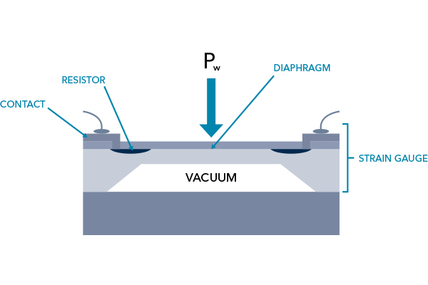
Depth is measured by a non-vented strain gauge transducer, which here we will call a pressure transducer (sometimes affectionately called a “depth ducer” in our halls). The pressure transducer is connected to resistors so that an electrical signal is sent when the pressure on the transducer’s diaphragm changes. One side of the diaphragm is exposed to the water, the other side is exposed to a vacuum. On the vacuum side, the pressure never changes. On the water side, pressure changes in response to the head pressure of the water (Pw), which is proportional to the water’s depth. So more water means more pressure which means more signal which is converted to engineering units (pound per square inch, PSI, or depth in m, ft, or bar). So there you have it, you know the depth of the water above the pressure transducer.
Sometimes these measurements are referred to as absolute depth. I’ve never really liked the “absolute” term; my brain always thinks it has something to do with a very low error on the measurement. Thinking it through, I suppose “absolute” refers to the fact that all the things that can exert pressure on the transducer’s diaphragm are going to be converted to that electrical signal that will be converted by the sonde’s firmware into depth. And that’s where things get messy...
Because you see, Pw is not only the pressure exerted by the water. It is also the pressure exerted by the atmosphere upon the surface of the water, and even the density of the water, which is affected by solutes like salt and environmental conditions like temperature.
For many applications these other factors are negligible. But in shallow water applications, two factors can have a serious impact: salinity (also interpreted as the specific gravity of water, ρ) and barometric pressure. The specific gravity of pure water, at room temperature at 1 atmosphere of pressure (i.e., sea level) is 1. The specific gravity of seawater is 50% higher, and even that is dependent upon temperature. Thus, salinity measurements, which take temperature into consideration, may be used to compensate water level measurements.
An example of where this might matter is in climate-change studies related to sea level rise, such as described in this classic YSI application note on sea level rise from Clam Bayou, Florida. The Clam Bayou case study also describes the second key variable, barometric pressure. Particularly in applications where the water depth is shallow (YSI considers <10 m to be shallow), barometric pressure fluctuations can affect the accuracy of water level measurements.
And hence, the vented level sonde.
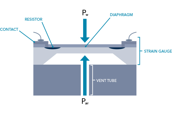
The pressure transducer in a vented level sonde is vented to the air via a vent tube. This enables the overall measurement to be automatically compensated for air pressure (Pair) when a differential pressure transducer is used.
Barometric pressure can fluctuate wildly, such as during storms. You may even know someone who can sense these changes—perhaps they get barometric pressure headaches. Altitudinal changes can also affect barometric pressure, a big factor in Lhasa where barometric pressure is so low. So let’s climb 3,650 meters up from Clam Bayou to see how important barometric compensation can be.

Barometric Compensation of Water Level at High Altitude
My colleague James installed an EXO1 vented level sonde at his client’s site in Lhasa, Tibet. One of his colleagues visited the site later and installed an EXO2 sonde with a non-vented pressure transducer in the same well where they wanted to look at water quality also. The non-vented sonde’s depth sensor had been calibrated in the factory.
The factory calibration was likely still very good (depth ducers are pretty stable). However, Yellow Springs, Ohio is at 260 meters above sea level, and the actual transducers themselves are calibrated in a pressure-controlled chamber. This is why one typically should calibrate their depth transducer on-site, in air, prior to deployment. In deep water applications where Pw >> Pair, this might not matter. If you’re using one of our vertical profilers in a surface water application, where the whole intent is measurements at depth, this calibration should certainly be done.
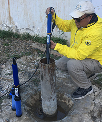
James’ colleague, however, wasn’t intending to measure depth, and so he hadn't calibrated the depth sensor. Nonetheless, the depth sensor was logging during the deployment, and 10 months later, James, pictured below swapping a freshly calibrated EXO1 sonde out at his own groundwater well, was looking at the data and noticed some striking differences.
James compared the measurements from his EXO1 sonde and his colleagues EXO2. In the graph below, the EXO1 level is in meters on the left Y-axis, and the EXO2 depth is in meters on the right Y-axis:

Looking at the data another way, James plotted the difference between the two lines, again using meters as the unit of measurement on the Y-axis:

This graph shows an ~6.5-6.85 meter difference in the water level measurements between the two sondes, but importantly it also shows fluctuations from about 6.67 to 6.84 m. This is the interesting thing we want to look at, and this will come up again in our final analysis. We’ve already hinted that the low atmospheric pressure in Lhasa may be a factor in both the fluctuations as well as the difference between the two sondes, but can that hypothesis be supported by the evidence?
James plotted measurements of atmospheric pressure in hectoPascals (hPa) on the right Y-axis, and the difference in depth (m) measured by the two sondes on the left axis. For reference, 1 standard atmosphere at sea level is 1013.25 hPa. So aside from how closely these two lines appear to track one another, the graph also reveals the very low hPa on the right axis, consistent with Lhasa’s high altitude.

James went on to evaluate the correlation between the difference between the two sondes’ depth measurements (X-axis, ΔDepth, in m) and the hPa on the Y-axis. Most environmental scientists would view this as a very strong correlation, as analyzed via linear regression:
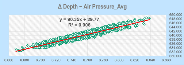
This makes a strong case for using vented level measurements for groundwater monitoring at high altitudes.
Accuracy Specifications
When I looked at the data, it occurred to me that if one wanted to know when water was pumped out or flowed in, the primary depth measurement might not be what matters. Rather, the ability to detect changes would be. In other words, supposing the 9 m starting point on EXO2 is actually wrong, yet I am still able to detect a few cm of change just as well as I would if I was using the vented level sonde, which was telling me I was starting at 3 m? Is that good enough, if I happen to have the EXO2 in my arsenal and don’t want to buy another sonde?
From the EXO User’s manual, here are the specs:
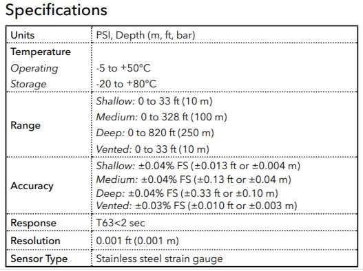
The EXO2 used in this study was the medium depth (100 m) sonde, which has an accuracy spec of about ±0.04% of full scale, which is ±4 cm. By contrast, the EXO1 shallow vented sonde (10 m) has an accuracy spec of ±0.03% of full scale, which is ±0.3 cm. This is an over 10-fold better accuracy!
However…what if James’ colleague had deployed a shallow EXO2 sonde that was not vented, rather than the 100 m model? He may have gotten closer to the measurement yielded by the EXO1 vented level sonde since the shallow unvented sondes (either EXO1 or EXO2) have an accuracy of ±0.4 cm up to a 10 m scale. That is, of course, if the EXO2 had been properly calibrated on-site.
Assuming you would calibrate, you might think, why bother with the venting at all then? 0.4 cm sounds pretty good to me!
Well…maybe…
Bear in mind that these accuracy specs are at sea level, under controlled conditions. Barometric pressure is still an interfering factor that must be taken into account. With the vented level sonde, this compensation for barometric pressure is done automatically. With the unvented, standard sonde, this must be handled externally, and now there is another error of measurement being introduced into the overall error budget. That means that in this highly remote area, some separate measurements of barometric pressure must have been taken concurrently, and reliably, with the level measurements from the sonde to ultimately do the barometric compensation to arrive at the final measurement of water level.
If that sounds a bit messy, that’s because it is. That’s not easily done when the changes in hPa differed by 2-4% (16 hPa) at James’ site in Lhasa:

Finally, the estimated volume represented by the level changes, relative to the total volume of the aquifer, is also important to understand when choosing an instrument. This will drive the overall accuracy needed for the application.
The Final Analysis: Did Any of This Matter?
So in this story, we have a few different things going on. There are two different types of measurements, depth and vented level. There is also the reality that the EXO2 sonde wasn’t calibrated on-site, adding further to the error of the depth measurement. Overall, though, what would have happened if James’ client was relying on the depth measurements of that EXO2 sonde instead of the EXO1 vented level measurements?
Looking again at the graphs above, the barometric pressure change had fluctuated between ~648-632 hPa. The water level change reported by EXO1 was about 6 cm (3.045-2.985 m). But the water “level” change reported by the EXO2 was 20 cm (9.98-9.68). We can estimate that ~17 cm the reported difference for the EXO2 was a consequence of the lack of barometric compensation (6.84-6.670 m, from the differential graph above). Without that compensation, then, how would an operator know whether surface water influx, withdrawals, or other factors were occurring at all?
This case study demonstrates why YSI recommends using a properly-calibrated, vented level sonde for groundwater level measurements. YSI’s standard recommendations for groundwater monitoring:
- The better accuracy of a vented level sensor is required for most groundwater applications,
- Whether automated (via venting) or manual, barometric compensation is advised at high altitudes, or where barometric pressure is prone to significant fluctuations, and
- If other water quality parameters are a priority, especially if salinity or specific gravity compensation might also be necessary, a vented level sonde, not just a pressure transducer, is the right solution.
YSI has a number of level sensors, including vented level sensors, and our colleagues at Global Water also did an excellent review of water level measurements in a webinar in 2020. A pdf of their slides can be found here.
I want to thank my colleague James Chen for sharing these data and analyses and coaching me in the writing of this blog. I of course also thank him for the excellent work he does for all of his YSI customers in China.
