AUVs Enable Real-Time Mapping, Sensing
It wasn’t long ago that the only option for obtaining quality imagery, bathymetric survey, and profiling data in rivers, lakes, and bays were to use hull-mounted or deployable sensors onboard specialized research vessels. Limitations on data collection included draft of the vessel, availability of personnel trained to operate the vessel and equipment, and labor and fuel costs. With the advent of Autonomous Underwater Vehicles (AUVs) and associated sensor technology, these limitations are rapidly fading.
Similar to the way that capabilities of cellphones and other portable electronic devices have progressed over the past decade, AUVs have benefited from the development of instrumentation that is smaller, more robust, more accessible, and more affordable. There is a wide array of instrumentation available on the newest AUVs, some of which weren’t considered or even available in previous iterations of the products.
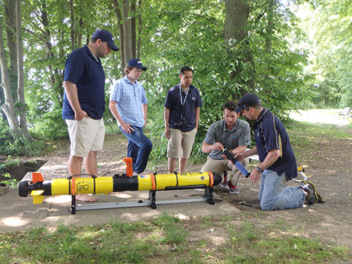
USNA Oceanography Department faculty engage in AUV training prior to deployment. Shown is the i3XO EcoMapper from Xylem’s YSI Integrated Systems and Services. Built on the Iver3 platform from OceanServer Technology, the i3XO is the newest AUV to come from the 10-year-old partnership between the two companies.
AUV as Teaching Tool
The United States Naval Academy (USNA) in Annapolis, Maryland, is situated at the confluence of the Severn River and the Chesapeake Bay. For years, USNA Oceanography Department faculty have monitored sections of the Chesapeake Bay, the Severn River, and other coastal estuaries for their own research endeavors and to provide the midshipmen with hands-on educational experiences. So when the department received funding from the Office of Naval Research to purchase an AUV as a research and teaching tool, they took the opportunity to support and enhance the curriculum with YSI Integrated Systems and Services i3XO EcoMapper AUV.
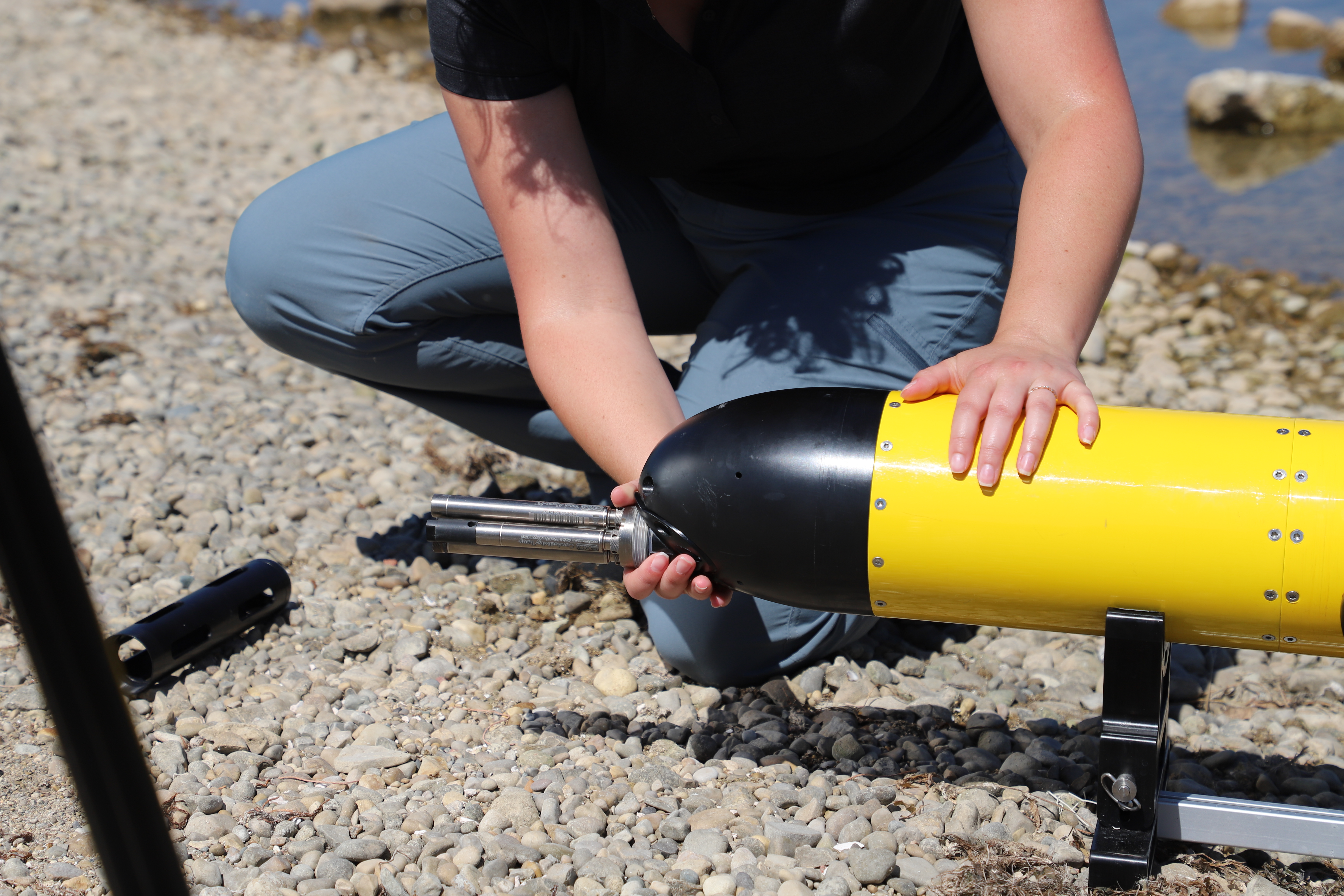
The USNA’s new EcoMapper includes a Doppler velocity log for navigation and current profiling; Tritech’s StarFish 452F side scan sonar for bathymetry; Imagenex 852 forward echosounder for object avoidance; Iridium satellite/Wi- Fi/2.4-GHz communications; and GPS for navigation. Also on the AUV is the YSI EXO1 multiparameter sonde water quality system with sensors measuring conductivity/temperature, pH, optical dissolved oxygen, turbidity and total algae.
Oceanography majors at USNA use the AUV in a variety of introductory and advanced courses, and honors students also use it to conduct research on currents in the Severn River. The data collected by the AUV provides midshipmen with expanded opportunities to engage in hands-on, real-time data collection, which is a valuable part of the learning process.
AUV as Workhorse
As with many advancements in technology, newer instrumentation with all the bells and whistles can often be finicky, cumbersome and lacking an intuitive interface. AUVs certainly run the gamut of user-friendly and effective, but given the working environment of underwater applications, most tend to be robust platforms with a ruggedized framework and easy-to-use simplicity. As such, AUVs have become workhorses in the field for all types of applications, from contractors to educational institutions. AUVs provide critical data to the end-user, without the tedious hours of human observation that would otherwise be required. And with improvements in portability, plug-and-play sensors and intuitive user interfaces, AUV installations have found many uses and applications across the globe. To name just a few examples, AUVs are in use at iron mines in Chile (and around the world) to monitor cooling ponds for environmental contamination and turbidity to ensure compliance with local ordinances; by dredging contractors prior to lake or river dredging to provide accurate floor mapping for water depth, obstructions and scopeof- work details; in graduate student and professorial research on water profiling, floor surveys and spot sample monitoring of coastal waterways, estuaries, lakes and rivers for obtaining baseline and ongoing environmental data; by universities as a teaching tool in the oceanographic, marine, environmental and related fields; and by government agencies for mapping and documentation surveys of bodies of water.
Whether the need is to teach USNA midshipmen or provide data to an iron mine, near-coastal AUVs can handle depths of 100 m or more, and are becoming the go-to solution for researchers and scientists across the globe.
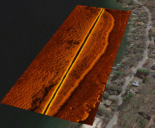
(Top and Bottom) With sonar and bathymetric surveying, over-laid with georeferencing, AUVs can provide detailed imagery of ocean, coast, lake and river bottoms. The nose of the EcoMapper contains object-avoidance sonar and high-resolution sondes for collecting water quality data.
Cutting-Edge Technology Integrated into AUVs
Given the compact nature of some of the technology available, AUVs today can be equipped with a comprehensive array of advanced instrumentation and can be deployed by one person from the shore or from a small boat. They can provide a wide area survey without needing a workboat or associated staff and can be mission programmed for up to 12 hr. with Li-ion batteries for long run times and a quick recharge.
In addition to typical AUV instrumentation like side-scan sonar imaging and bathymetric surveying, which provide researchers and scientists with detailed imagery for bottom mapping, AUVs are now available with sondes, providing high-resolution water quality data, measuring as many as eight different water quality parameters at a time.
>>> Ask a Question
From dissolved oxygen or pH to turbidity and conductivity/temperature (CT), researchers can benefit from the compact technology fitted into the nose of the AUV. And because of the undulations of the AUV through the water column, data can be provided in both the horizontal and vertical planes for a more accurate representation of real-time nuances.
Downward-looking current profiling and Doppler velocity logs to measure water velocity are additional capabilities that the research and scientific community are finding valuable on board an AUV application to help monitor tidal activity, weather patterns and overall health and well-being of a body of water.
Where’s My AUV?
Many researchers would be rightfully concerned about sending a piece of equipment worth well more than $100,000 out into the field untethered. And many AUV manufacturers sell their products only with a tether for specific purposes of retrieval if need be. Still, others, such as the i3XO EcoMapper, come with a location identifier, so that the end-user always knows the exact GPS coordinates of the unit. It also comes with a “find my AUV” type of capability to help notify the user of its whereabouts when in mission mode. To help avoid obstacles, AUVs will often come with front-facing sonar, similar to that found in most new automobiles, helping the AUV modify its course should there be an obstruction to the preprogrammed operating mission.
Smart and Intuitive
As is the case with much of the scientific instrumentation that is on the market today, the instrumentation on board the AUVs—and the AUVs themselves—have become easier to use, easier to program and easier to maintain. For example, Xylem’s YSI Systems and Services, which specializes in product integration, has taken the advanced Iver3 platform from OceanServer Technology Inc. and customized it with numerous add-ons, such as side scan sonar, Doppler velocity logs and YSI water quality sondes to provide the ultimate portable monitoring vehicle for research scientists.
Besides these advanced capabilities, the AUV stands as a robust autonomous platform with mission-planning software that’s easily programmed via a user-friendly interface and step-by-step process to map out any customized mission.
Using GPS coordinates and standard back and forth “lawnmower” patterns, the AUV can cover as much ground and detail as required to obtain the necessary data.
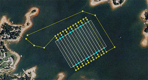
Screenshot from OceanServer's VectorMap mission-planning software showing a lawnmower-style mission path overlaid onto an image of a saltwater lagoon.
More Instruments, More Data
With the increased amount of instrumentation on AUVs, there is the need to transfer the data to the researcher or scientist in a convenient manner.
Some AUVs do this via Wi-Fi, broadcasting their own Wi-Fi for configuration and for data retrieval. Other, more advanced AUVs, also have built-in Iridium antenna receivers in order to transmit specific information such as GPS coordinates, waypoints, battery life or vehicle state.
As the AUV rides along the surface of the water, the information is transferred to a base station or to any interface with an Internet connection. Once the data have been obtained, they are often aligned with other mapping or imaging technologies using georeferencing to help paint a more comprehensive picture of what the instrumentation picked up along the bottom.
Smaller, Better, Faster, Cheaper
When looking to purchase a new AUV, the prices tend to run a dramatic range, from well under six figures to well over. The costs are in direct correlation to the technology on board and the range and amount of instrumentation that is installed. When you compare the cost of a fully equipped AUV, versus that of a research vessel or a team of scientists, the cost-benefit analysis starts to make a lot of sense to government agencies, the military, universities, contractors and private organizations. And as the technology becomes more advanced and more compact, and the data become more available, researchers and scientists—whether they’re monitoring water quality parameters in a large river or engaging in a dredging project and need the detailed mapping of a lake floor—can take advantage of AUVs and the rapid advances of the instrumentation that are being outfitted on these valuable portable laboratory vehicles.
Acknowledgments: Captain Emil Petruncio of the U.S. Navy and Alexander R. Davies, an oceanography instructor at the U.S. Naval Academy in Annapolis, Maryland, contributed to this article. Davies can be reached at adavies@usna.edu.Shawn Sneddon is an instrumentation and application engineer at YSI Integrated Systems and Services, a Xylem brand, and can be reached at shawn. sneddon@xyleminc.com.

Additional Blog Posts of Interest
Ecological Monitoring of Coastal Wetlands with Real-Time Telemetry
The Evolution of Water Quality Monitoring [Free eBook]