Creative Water Quality Mobile Bay Study
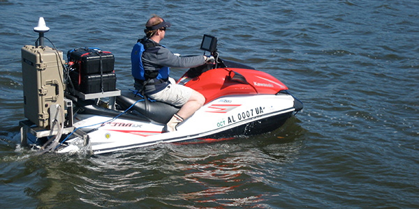
Buzzing across Mobile Bay at 40 knots on his red-and-white Kawasaki Ultra LX personal watercraft (PWC), University of South Alabama’s Bret Webb (@dr_bw) isn’t just another waterborne thrill seeker looking for a good wake to jump. His PWC is a state-of-the-art research vessel, outfitted for bathymetric surveying, multiparameter water quality sampling, and sophisticated water velocity studies in the challenging shallow estuarine environment.
When the Deepwater Horizon oil platform exploded and sank about 100 miles off the mouth of Mobile Bay in April 2010, Dr. Webb put his unit into high gear, putting his maneuverability, speed, and skills to work studying the movement of oil and refined fuels from the spill in the rich fishery.
Webb’s work with his Jag Ski – named in honor of University of South Alabama’s Jaguars – offers insight into the dynamics of the Mobile Bay estuary, the performance of structures designed to repair the barrier island at the mouth of the Bay, and the potential of the PWC as a research tool
Shallow Bay, Deep Challenges
Mobile Bay is roughly 30 miles long by 12 miles wide (48 km by 19 km), a drowned river mouth estuary that receives an average freshwater discharge of 63,000 cubic feet per second (1,800 m3/sec) from several rivers, including the Mobile and Tensaw. The bay’s average depth is just 10 to 12 feet (3 to 4 m), sliced through by a 40-foot-deep (12 m) shipping channel.
The broad, shallow expanse of the bay and the renown of the University of South Alabama’s Department of Civil Engineering make it a hotspot for research on bridges and causeways. Webb initially equipped his Jag Ski to study scour holes near bridge foundations and study nearshore currents, using the PWC’s compact size and excellent maneuverability to access study sites out of reach of most boats.
“We wanted a tool we could use to do bathymetric surveys in shallow areas – an overlap between traditional land-based surveys and traditional water-based surveys – something that could get us across the surf zone,” Webb says. “In terms of access and ease of use, the PWC cannot be rivaled.”

Bret Webb has used his Jag Ski – outfitted with a SonTek Acoustic Doppler Profiler (RiverSurveyor M9) and a Portable Sea Keeper water quality testing system – for bathymetric surveys, multiparameter water quality testing, and studies of the flow of water and pollutants in the Mobile Bay estuary system.
Webb met with Kyle Waits, regional manager for the Gulf Coast for YSI, and Kevin Labbé, Application Specialist for YSI, to explore his options for outfitting his nimble watercraft. Waits described the SonTek/YSI RiverSurveyor M9, an acoustic Doppler profiler (ADP) with multiple frequencies and precise bandwidth control designed to deliver high-resolution velocity and direction measurements in a range from 0.2 feet to 130 feet (6 cm to 40 m) of depth. The RiverSurveyor M9 is also equipped with real-time kinematic (RTK) GPS, providing extremely accurate measurement locations.
“The system that Kyle and Kevin told me about really seemed to fit with the future applications of the Jag Ski,” Webb recalls. “We need to collect a string of GPS data to make corrections based on the trajectory of the ship. Those are not trivial exercises. I have been really impressed with the integration of GPS and ADP in the RiverSurveyor.
“Second only to the GPS is the multiple frequency on the M9,” he adds. “The problem with single-frequency profiling is you’re going to have good resolution in some areas and poor resolution in others. Pre-programmed frequency hopping based on the depth of the sample presented itself as a really good option.”
The RiverSurveyor has provided insight into the variations in flow across the bay as well as in the depths of the shipping channel, where velocities can differ dramatically.
CastAway-CTD Adds Resolution
The dynamics of river discharge and tides from the Gulf of Mexico result in a wide range of salinity in Mobile Bay. Salinity is typically measured in practical salinity units, or PSU, which range from 0 for pure freshwater to 42 for highly saline ocean water.
“It is not uncommon to see salinities as low as 5 PSU at Main Pass, its primary connection to the Gulf of Mexico,” Webb notes. “By contrast, during drought conditions, the salt wedge pushes well north of the Bay into the delta and rivers. So during the same survey in the Bay, it would not be uncommon to have salinities ranging from 5 PSU – almost freshwater – to 30 PSU, which is near oceanic salinity.”
Because the speed of sound is significantly influenced by salinity and temperature, measuring those variables is vital to an accurate study, Webb says.
“That’s a very important part of processing ADP data,” he emphasizes. “It may not be so much of an important part of the study of a drainage canal, but it’s really important in a coastal estuarine environment.”
Webb uses a CastAway CTD, a palm-sized instrument that measures conductivity, temperature, and depth. Every kilometer or so along his transect, he casts the instrument, letting it free fall at a steady rate to capture CTD data at a rate of five samples per second. Data from the CastAway integrates directly with the ADP’s RiverSurveyor Live software package, generating sound speed corrections for the acoustic data.
It’s a simple task, but Webb says measuring salinity regularly along the transect is critical.
Water Quality Monitoring Joins the Mix
When the Deepwater Horizon sank in 4,132 feet (1,259 meters) of water, causing the largest offshore oil spill in U.S. history, Webb contacted YSI again. He had secured a National Science Foundation grant to use the Jag Ski to monitor the spill’s environmental impact on Mobile Bay and wanted to add a complete water quality monitoring system to the Jag Ski.
YSI Integrated Systems and Services built him a Portable SeaKeeper 1500, a compact version of the renowned multiparameter water sampling systems deployed on ferries, commercial ships, and other vessels of opportunity around the globe.
At the heart of the Portable SeaKeeper is a YSI multiparameter sonde, equipped with probes to measure temperature, conductivity, pH, turbidity, dissolved oxygen (DO), and chlorophyll. The Portable SeaKeeper also contains a submersible fluorometer from Turner Systems that measures chromophoric dissolved organic matter, crude oil, and refined fuels.
With a diaphragm pump and manifold system that keeps a steady flow of water over the instruments from 4 inches (10 cm) below the surface and an inlet designed to track with the PWC as it turns, the Portable SeaKeeper can sample accurately at speeds as high as 40 knots, reporting data at five samples per minute.
Webb set to work measuring the concentrations of hydrocarbons in the near-surface waters of the Bay, studying the residence time of the pollutants, and characterizing the roles of wind, tide, and freshwater forcing on the movement of the oil. Combining his near-surface water quality data with bathymetry and velocity data collected with the RiverSurveyor M9, Webb will shed light on transport pathways across the Bay and delta, and help isolate seasonal and tidal variability in bay dynamics.
Fast and Slow
Webb also deployed the Jag Ski to study BP’s effort to close off a breach in Dauphin Island, a barrier island at the mouth of Mobile Bay. Opened by Hurricane Ivan in 2004 and widened by Hurricane Katrina the following year, the breach left sensitive wetlands and oyster beds vulnerable to oil from the spill. Using the RiverSurveyor M9 and the Portable SeaKeeper, Webb characterized the dynamics of the breach, then studied the impacts of BP’s rubble mound structure.
Such integrated projects highlighted a challenge for the broadly equipped Jag Ski – the high-speed capabilities of the Portable SeaKeeper contrast with the need for slow vessel speeds when measuring the velocity and direction of slow-moving water, Webb notes.

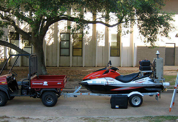
The South Alabama Jag Ski and 4x4 towing vehicle and SonTek RTK GPS solution, which offers an incredibly precise, fully integrated boat speed solution to augment, or be an alternative to, bottom tracking.
“The main thing is to develop a very good plan ahead of time and then be prepared to make adjustments on the water as needed,” he says. “To achieve near-synoptic measurements of surface water processes, we would work our way up the bay on a rising tide, or down the bay on a falling tide. This helps minimize the tidal bias of the measurements over large survey areas.”
It’s not easy to creep a PWC along at the almost imperceptible velocity of the bay’s current for accurate ADP measurements, Webb adds, but he’s developed tactics that allow him to crab at ground speeds as low as 0.3 to 0.5 meters per second using the Jag Ski’s reverse feature.
Webb has also learned through trial and error how to collect the highest-quality data by optimizing the features of his equipment – for instance, determining when it is best to decide for himself when to use the pulse coherent or incoherent modes on his RiverSurveyor, or when the instrument’s automatic-shifting SmartPulse system is the best way to go. Similarly, he has taken to carefully scrutinizing data from the very edges of coastal inlets, which are much less defined than the riverbanks and canals where RiverSurveyors are often deployed, he says.
Versatile Software
Webb has also learned to make the most of the RiverSurveyor Live software, a highly intuitive package that yields real-time water velocity, direction, and estimates of discharge. The software allows him to view multiple data sets simultaneously during surveys on the waterproof computer aboard the Jag Ski, or back in the office on his PC. The program integrates GPS, CTD, and ADP data seamlessly, and exports easily to HYPACK for more intensive processing.
Webb says point-and-click functionality allows him to pull data and graphics straight from RiverSurveyor Live for a variety of uses.
“For scientific publications, I like to change it and clean it up, but for project reports or a proposal to solicit funding, it’s as easy as cut, copy, paste into a Word document,” he notes.
With the versatility and phenomenal data-gathering capacity of the Jag Ski, expect plenty of upcoming research proposals and reports. Webb envisions a future filled with studies of bay dynamics, tracking harmful algal blooms, measuring and analyzing water quality parameters for total maximum daily loads (TMDLs) around the bay, and a wide variety of other studies.
At YSI headquarters in Yellow Springs, Ohio, Kyle Waits points out that Webb’s compact Jag Ski packs capacity from across the diverse company’s equipment lines.
“Bret’s Jag Ski is very dynamic,” he says. “This is an integration of all our various business units – bathymetry, water velocity, and real-time water quality collection, all tied together.”
Adding to the dynamics is the unmistakable allure of the hot-red-and-white collecting platform shooting across the surf zone of Mobile Bay. “One could certainly put all this instrumentation on a larger vessel and collect the same data,” acknowledges Webb. “But it wouldn’t be as cool.”

Additional Blog Posts of Interest
Ecological Monitoring of Coastal Wetlands with Real-Time Telemetry
Real-Time Water Quality Data Used to Protect Ecosystem During Dredging
7 Tips to Fight Fouling and Extend Water Quality Sonde Deployments | Tip #1
Advanced Water Quality Assessment Program | Ferries for Science