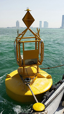
Real-Time Water Quality Data Protects Ecosystem
Located on the coast, in the northern part of the municipality of Al Daayen, is the site for the newest symbol of Qatari progress —Lusail city. Lusail city will include man-made islands and a host arena for the 2022 FIFA World Cup.
As part of the construction, a local dredging project is taking place. The focus of this project is to transform the current shoreline by increasing depth of navigation channels and creating the man-made islands for Lusail.
Though dredging is a necessary routine in waterways, it is not without its challenges. “Dredging, if unmonitored, can cause high sediment concentration, which will have a negative impact on the ecosystem,” explains Xylem Regional Manager Hassan Al Salem. The extent to which dredging can impact the ecosystem varies depending on a number of factors, however, monitoring can help officials maintain a safe environment during construction.
Water Quality Is Key
Recognizing that water quality monitoring is key to ensuring the protection of the ecosystem, the local environmental agency took action and installed a network of eight water monitoring buoys. Each buoy contains a YSI EXO2 Sonde, and Storm 3 Data Logger with real-time data via GPRS.
Set to collect data at designated time intervals, the EXO2 Sondes and Storm 3 data loggers seamlessly work together to monitor turbidity and dissolved oxygen (DO) at the sites. Designed for quick and easy calibration, the sondes allow long-term deployment with minimal maintenance.
Delivering the Data
The ability to deliver data quickly was the main challenge for these sites. “Dredging equipment is expensive to operate, and even more expensive when not operating,” explains Al Salem.
The innovative technology of the Storm 3 data loggers, automatically pushes to a cloud-based hosting system, allowing real-time monitoring of the sites without sending a technician into the field. Collection of data obtained remotely from the buoys is a safer and more cost-efficient method than traditional water quality measurements by routine boat patrols and allows water quality to be monitored during storms or other events.
“Online monitoring of the water quality helps in providing efficient operation while ensuring the ecosystem will not be affected, “ continues Al Salem.
To ensure water quality remains at safe levels, the system is set up to initiate an alarm via SMS text or email if a threshold of 10 Nephelometric Turbidity Units (NTU) is exceeded. (Learn more, Turbidity Measurements: Tips & Precautions). In addition to email and text alarms, officials can quickly check site icons, which change colors with changing conditions and assess data in both graphical and tabular display.
With the help of Xylem brand instruments and advanced water monitoring technology, officials will be able to identify harmful water quality levels and take action, if needed, to protect the surrounding ecosystem while constructing Lusail city.

Additional Blog Posts of Interest
Studying Coral Bleaching Events with Mission: Water
Impaired Ecosystem Monitoring in Mount Hope Bay
Estuary Research Project Highlights Advantages of Continuous Monitoring
Sea Level Rise Research: Clam Bayou Estuary Florida