Water Quality Sonde Survives Alaskan Flood Waters
The Crooked Creek Watershed, located north of Fairbanks, runs through some 300 square miles of Alaska’s central interior. In the past, this area was a hotbed for placer gold mining, but modernity has changed the landscape into a collection of humble creeks, sleepy rural communities, and some small-scale mining operations.
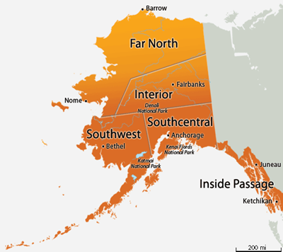
Crooked Creek Watershed is located north of Fairbanks, in Alaska’s central interior.
In 1992, due to both historical and contemporary mining activities, multiple streams in Crooked Creek were placed on the Clean Water Act 303(d) list. In essence, this means that the impact of human activity on the watershed has contributed to demonstrably lower water quality. Looking back at data from the 1980s and 1990s it was shown that turbidity levels were on the rise, and this was largely attributed to a lack of best management practices at mines at the time.
Having been placed on the 303(d) list for impaired waters, and with a new state-administered mining permit program in place for mining operations, Crooked Creek has a robust monitoring program overseen by the Alaska Department of Environmental Conservation – Division of Water (ADEC). Every two years Environmental Program Specialist, Chandra McGee, must submit a report on these waters to show if the changes in mining practices have had a positive impact. Their goal is to one day remove Crooked Creek from the 303(d) list.
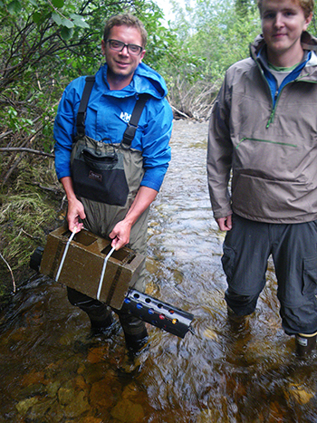
Undergraduate interns on-site preparing to deploy a horizontally mounted EXO2 sonde.
To this end, Chandra has been deploying four YSI EXO2 sondes across the watershed, monitoring these threatened waters chiefly for turbidity – but also checking for pH, dissolved oxygen, conductivity/temperature, and flow. With assistance from undergraduate intern Brian Stillie, and members of the ADEC mining section – the crew aims to determine if the streams are meeting their turbidity goals.
The streams at Crooked Creek are physically shallow, which presented some challenges to Chandra’s team. Typically in deeper waters, a vertical deployment is preferred as it offers maximum protection for the instrument while providing high-quality data. However, not having this option, the team devised a horizontal deployment to capture the data they need.
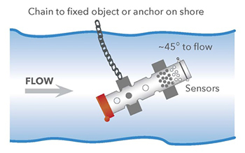
Illustration of a horizontal deployment for long-term monitoring.
The EXO2 sondes were first housed in a protective PVC pipe that had been vented with 2.5” holes to allow a good flow of water to the sensors. The pipe was then secured to a pier block and strapped inside a cinder block to help hold it in position. Lastly, the entire deployment package was cabled-tied to a tree on the shore; just to be sure there was a fixed anchor point for the monitoring system.
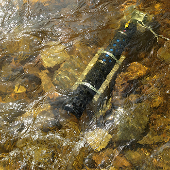
Before the Flood: EXO2 sonde was deployed in PVC housing attached to a cinder block and pier block. It was also fixed by cable to a tree on the bank.
Despite this professional and well-executed horizontal deployment – Mother Nature, it seems, had different plans. To quote Chandra McGee, “We’ve had a huge amount of rain in interior Alaska this year. Over the July 4th weekend, there was a flood in the watershed…with the EXO sondes. One was buried – but we were able to recover it.”
The sonde was found buried after the flood about 1½ feet under sand and rocks. Thankfully the fixed cable was still attached to the tree on the bank – so finding the sonde was straightforward enough, and a reminder of why good construction practices are important for sonde deployments.
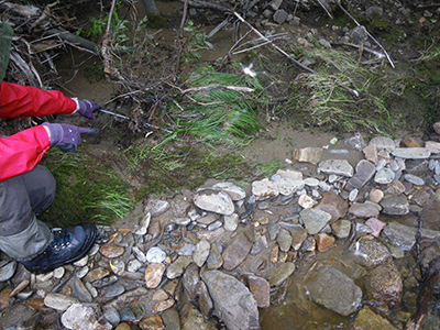
After the Flood: EXO2 sonde was buried approximately 1½ feet deep under sand and rocks, but still attached by cable to a tree on the bank.
After unearthing the sonde, Chandra’s team found that the EXO2 was still running. The central wiper had taken some damage from flood sediment and needed to be replaced. But, after a thorough cleaning, the data was downloaded and the sonde was successfully re-deployed in the field.
Chandra went on to say, “We were very impressed at the durability [of the EXO platform]!”
One sonde of the four, sadly, was lost in an area of the flood that also washed out an access road. At that site, even the tree that anchored the sonde was swept away, and so the equipment has been assumed lost. Chandra commented, “I expect that the sonde we lost is still collecting data, buried somewhere until the battery dies.”
The loss of equipment can certainly be a setback. However, because Chandra’s team observed proper procedures for horizontal deployments they mitigated their losses to only one sonde out of four.
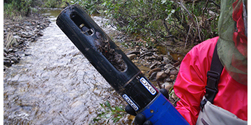
EXO2 sonde still running after being dug out.
The central wiper was replaced due to damage from the flood.
The EXO2’s that were recovered are a perfect example of the EXO platform's high-quality design and durable construction. Despite a flood, being buried, and going through the stress of being unearthed – the sonde never missed a beat in capturing data. They are currently returned to the field, doing their job assisting the ADEC in evaluating the future of the Crooked Creek Watershed.
Learn more about how the team at the Alaska DEC is researching and protecting the nation’s waterways.
Additional Blog Posts of Interest:
Get the Most From Your Water Quality Sonde - Recorded Webinar
10 Tips to Prevent Biofouling on Water Quality Instruments
Trouble Collecting Data with Your Water Quality Sonde? Try This!
YSI Expert Tip 1 of 7 - Getting Your Water Quality Sonde Field Ready