Understanding the Tijuana River Estuary
To put it bluntly, the situation around the Tijuana River and its estuary just north of the U.S.-Mexico border stinks.
Once a seasonal river with a sprawling estuary, the Tijuana River has taken to flowing year-round with what Tijuana River National Estuarine Research Reserve (TRNERR) lead science coordinator Jeff Crooks calls "urban drool"—runoff from irrigation, car washing, sidewalk scrubbing, and other human uses. Worse, the failure of two of the four wastewater treatment plants on the river in recent years has led to summer flows that are almost pure, raw sewage entering the Pacific at the mouth of the Tijuana.
Homeowners complain about odor and eroding beaches. Tourists are frustrated. Business owners who depend on beach visitors are worried. And scientists are afraid for the health of the estuary and the organisms that live there. All combined, this puts the Tijuana River Estuary under the microscope.
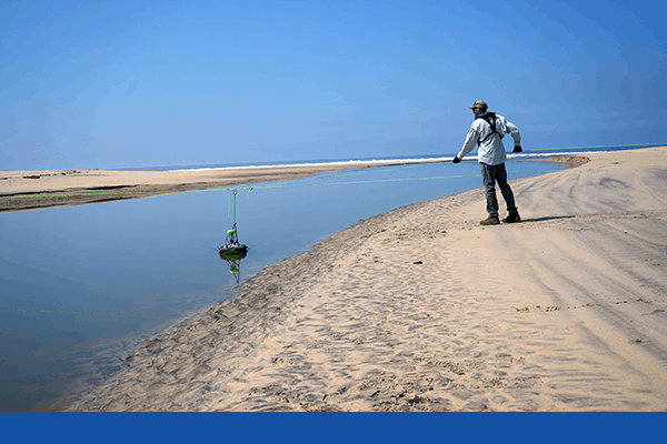
SonTek Technical sales expert Matt Klipfel uses the RS5 ADCP to gather highly precise tidal flow data at the mouth of the Tijuana Estuary, where waters merge with the southern California Pacific coast.
"We need to know in much greater detail what is the role of the estuary in retaining and removing pollutants and how does that change during storm events compared with sewage release events—and the fundamental question, what's the total load of pollutants to the ocean?" says Trent Biggs of San Diego State University (SDSU).
Crooks adds, "We're planning a restoration on 80 acres [32 hectares] or so, and our bathymetry and water quality research is providing important pre-restoration information."
Both researchers eagerly participated in surveys of the Tijuana River Estuaries with SonTek acoustic Doppler current profilers (ADCPs), which provided detailed data on the bathymetry of the river channel and tidal creeks, as well as on the movement of water in the system.
Crooks points out that estuaries are very different than rivers and require site-specific research. "When you try to make a rating curve for the estuary, it's completely backwards—it's not what happens with rivers," he says. "In the estuary, the tide comes in and the current slows down, then stops at the highest water level."
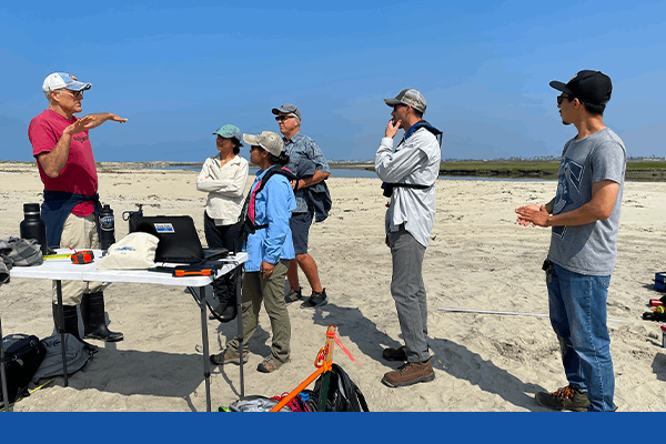
SDSU Research Lead Dr. Trent Biggs explains the tidal flows in the Tijuana Estuary and strategizes the optimal placement of ADCP transects for precise data collection. L to R: Dr. Trent Biggs, Callie Summerlin, Dr. Xue Fan, Jeff Crooks, Matt Klipfel and Julian Gutierrez.
Precious Ecosystem
Just 10% of California's historic coastal wetland habitat remains, Crooks notes, making the Tijuana River Estuary a precious fragment of an endangered ecosystem. The estuary is a nursery for young California halibut and baby leopard sharks. It is also home to ground-nesting birds, including three endangered species. The salt marsh serves as a buffer against storm surges and a filter that captures contaminants from the river before they reach the ocean.
But that vital 1,000 hectares is threatened by deforestation and urbanization in its 450,000-hectare watershed. As the river winds through the watershed on its 193-kilometer path from the highlands of Baja California to the Pacific, it passes the factories and neighborhoods of Tijuana, then the ranchettes and developments of southern San Diego County. A pair of broken-down sewage treatment plants pour raw wastewater into the channel. The river also picks up eroded sediments that have filled 75 percent of the original tidal prism and raised elevations so significantly that much of the old salt marsh has converted to upland habitat, according to Crooks.
Ironically, those sediments could help reduce beach erosion north of the Tijuana River's mouth, but the four dams along its course prevent the historic winter floods that used to push sand and silt out of the estuary and into the ocean. Today, the sand and silt that migrate downstream chokes the estuary instead.
"It's those two processes: more sediments getting delivered during small and medium-sized events, and then the lack of large [flow] events that would help scour the system," says Biggs.
The movement of sediment within the estuary also dramatically changes the bathymetry of the system frequently. Sandbars forming at the mouth of the river can even trap sewage in the estuary if they are not cleared by reserve managers. The result is a dynamic system that is tricky to manage and where it is difficult to track discharge with typical long-term monitoring solutions.
Positioned where the Tijuana River meets the ocean, the Tijuana Estuary serves as a basin for pollutants from varied sources across the U.S. and Mexico, leading to environmental degradation. A key tool deployed to tackle this issue is the SonTek-RS5 Acoustic Doppler Current Profiler (ADCP), which plays a crucial role in tracking tidal flow.
What Lies Beneath
Researchers have mapped the estuary and studied changes in the marsh. But they understood little about what happened beneath the surface of the river and its tidal creeks, both in terms of the shifting sediment and their active currents. Biggs contacted senior application engineer Xue Fan at SonTek for help surveying the bathymetry of the river and several of the tidal creeks in the Tijuana River estuary, as well as a detailed look at the water movement.
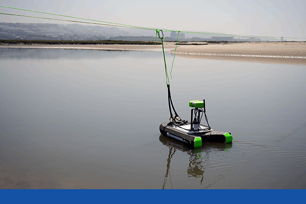
In late 2023, Fan and SonTek regional sales representative Matt Klipfel used a SonTek M9 ADCP to conduct a bathymetric survey. Mounted on a remote-controlled YSI rQPOD remote surface water vehicle, the M9 employs nine transducers to map depth and analyze the speed and direction of currents throughout the water column.
In one of the first site studies conducted in 2023, SonTek's Matt Klipfel and Dr. Xue Fan use the SonTek-M9 to conduct the first bathymetric survey that was used to examine scour of the river mouth to develop a bathymetric baseline to compare to satellite imagery to infer suspended sediment load.
They returned in March 2024 with a SonTek RS5 ADCP to conduct discharge measurements at the river mouth. The RS5 is smaller than the M9, with five transducers and a 3.0 MHz signal optimized for shallow depths over a wide range of changing flow conditions. With the RS5, Fan and Klipfel created a detailed time series of water velocity, direction, and discharge through a complete outgoing tidal cycle.
The two surveys highlighted the power of the SonTek ADCPs. They showed not only a strong sense of how the channels change as water and sediment move around the system, but also how river water and ocean water behave when they meet—often differently than expected.
For instance, in the March transect, the SDSU and TRNERR teams observed velocities that were uncharacteristically high along the bottom, while water closer to the surface moved surprisingly sluggishly. That is an unusual velocity structure compared to most river systems, notes Fan.
Biggs adds that he was surprised at the dynamics of salty ocean water and river water in the estuary.
"The top half-meter or 50 centimeters of the estuary looks like fresh river water, and the bottom meter looks more like ocean water, so there's much less mixing than we had anticipated," he explains. "There's a lot of salinity-driven stratification of the water column, and that has really important consequences for pollutant removal, mixing, and dilution because if the river flows are sliding on top of a salty under-layer, then it has less time spent in the estuary and likely has less potential for pollutant removal. So we're still trying to understand those dynamics."
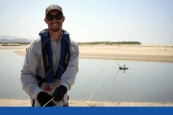
SonTek Technical Sales Expert, Matt Klipfel, expertly manages a tagline guiding the RS5 during its transect across the estuary outlet, ensuring the device’s speed matches the water flow for accurate data collection.
Ideal Tool
Fan says she carefully considers the best approach to help researchers achieve their objectives, even if the best answer turns out to be a non-ADCP solution. However, she realized that Biggs' request was a perfect application for the ADCPs.
"You get instantaneous geometry, you get instantaneous velocities, and in that way, you get a snapshot in time into what discharge is doing at that moment," Fan notes.
"In the estuary in particular, there are flow reversals, there's some slack water, and there's sedimentation happening, so the water is pretty murky in some areas," she adds. "The M9 and the RS5 have our SmartPulse auto-adaptive feature that adapts automatically in changing environments, choosing the optimum frequency, acoustic signal type, and cell size for the depth and conditions. You don't have to manually program the instrument for a particular situation."
Fan notes that the RS5 also features a coded pulse-coherent signal to minimize ambiguity, which is especially important in the changing velocities and directions of the estuary. The ADCPs also back up their bottom tracking signal with RTK-corrected GPS location data, which was extremely helpful where strong currents along the channel bottoms created moving bed conditions that can challenge traditional bottom tracking.
The results of the bathymetry and discharge surveys revealed details that stationary level gauges can't capture.
"We weren't aware that we had such a complex site with such a complex flow structure," Fan says. "This is very valuable information because normally, at gauging sites, you make basic assumptions about the flow structure, and all your equations use those assumptions to get to the final discharge data."
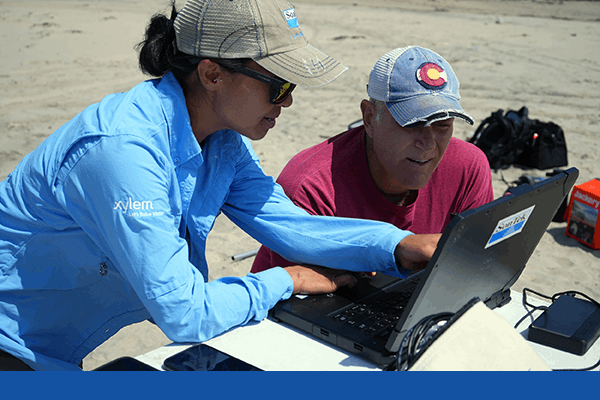
SonTek Senior Application Engineer, Dr. Xue Fan, reviews RS5 data as it is being collecting in real-time during one of the many transects being conducted during the all-day exercise.
Water Quality Proxy
Biggs and his SDSU colleague Natalie Mladenov have demonstrated that they can reliably measure turbidity and concentrations of sewage in the Tijuana River in real-time by monitoring tryptophan-like fluorescence with water quality instruments. They are also using reflectance of red light in satellite imagery of the river and estuary to monitor sewage, though Biggs points out that the remote sensing approach is tricky in shallow water.
"The satellite doesn't know the difference between a sandy bottom and dirty water," Biggs explains. "So we have to have continually updated maps of the bathymetry to be able to interpret the satellite imagery and use it as a tool for documenting pollution dispersal. If you know the depth to enough precision, you can also develop a correction that you can use to more accurately map organic matter and turbidity."
The new data on sewage flows and turbidity complement a treasure trove of data the TRNERR staff has collected every 15 minutes since 1996 with YSI instruments, including the reserve's current suite of YSI EXO multiparameter sondes (EXO1, EXO2, and EXO3).
"We're monitoring the outcomes of all the management interventions that are happening around sewage collection and treatments, so we'll be able to determine things like how much pollution is not reaching the ocean now, what's the mitigation or net result of sewage collection and treatments, and what the additional load of bacteria is during storm events," says Biggs.
The research teams are working now to figure out how often to conduct future bathymetry surveys.
"What they need to do is understand how fast the whole environment is changing so that if they adopt a long-term monitoring solution for organic matter and sewage, they understand how frequently they need to return to do these surveys," Fan notes. "People have struggled to monitor areas like this. We've only scratched the surface on how and where to take these discharge measurements to find different choke points in the estuary to strategically measure and understand so they can model exactly how the water is moving. If we can show that it's possible—that there are methods and instruments out there capable of this work—I think that's a huge step in estuary research."
Resilience Shows Through
TRNERR researcher Crooks says the bathymetry, discharge, and water quality monitoring efforts reveal serious water quality challenges, but also provide signs of hope for the Tijuana River and its estuary. Despite the dramatic loss of tidal prism to capture pollutants, the plants, soils, and microbial community are still helping clean up the water before it reaches the sea.
"I'm not happy that sewage is just flowing into it, but it's better to flow through a wetland and out to the ocean than just through a straight concrete channel out to the ocean, which was the original plan in the 1960s," he notes. "In general, I've been more impressed by the resilience of the estuary than by its vulnerability."
That, Crooks notes, provides a promising place to start as he and his colleagues restore more of the estuary.
ADDITIONAL INFORMATION
Protecting the Remaining Tidal Prism
Monitoring bathymetry in the Tijuana River Estuary helps estuary managers keep track of sedimentation, which threatens the system. Sediments carried to the estuary by the Tijuana River have caused the loss of approximately 75 percent of the estuary's tidal prism—the low-lying wetlands that filter estuary water—according to Jeff Crooks, lead science coordinator for the Tijuana River National Estuarine Research Reserve (TRNERR).
"When you fill in a salt marsh with sediment or you cut it off to the tides, you lose tidal prism," Crooks explains. "There's less water coming and going with the tides. You lose the benefits of the wetlands, which take up pollutants and clean the water. And the primary thing for us has been that the flow of water in and out of the mouth helps keep the tidal inlet open, so the estuary fills and drains, fills and drains. As the place gets filled with sediments, there's less water moving around. It's filling up less and draining less, so there's less scour at the mouth. And that can lead to mouth closures and a closed system."
Tijuana River Estuary Provides a Preview of Sea Level Rise During Big El Niño Years
Jeff Crooks, lead science coordinator for the Tijuana River National Estuarine Research Reserve (TRNERR), points out that strong El Niño events create warmer waters and a slight elevation in sea level. That provides a preview of the likely impacts of rising sea levels on coastal wetlands. Studying the bathymetry and water flow in the Tijuana River Estuary can provide important insights to help guide future management, he says.
"What we've seen twice—in 1983 and 2016, during big El Niños—is it actually closes the inlet because you get big waves riding on top of an elevated sea level that's pushing a whole bunch of material into the inlet," Crooks notes.
Using acoustic Doppler current profilers like the SonTek M9 and RS5 can provide more details than ever on how water and sediments move under those conditions, he adds.
"Most of the metrics we have about tidal wetland restoration and what needs to be done are habitat metrics: 'How many acres of this have you made? How many acres have you lost?' That's totally appropriate because a lot of the currency for what we're trying to deal with is endangered species habitat," Crooks says. "But what we really need is estimates of function. 'How much water is actually going in and out of the mouth? How much have we actually improved the hydrology here? How much have we increased the tidal prism?' Our program is aimed at trying to get some of that back, so what we're exploring here is a really important complement, a piece of the puzzle that we're trying to restore."
SonTek SmartPulse Adapts Automatically
One of the most exciting features of the latest generation of SonTek acoustic Doppler current profilers (ADCPs) is SmartPulse, which automatically adjusts for depth and velocity to ensure the optimum signal for accurate profiling.
Xue Fan, SonTek senior application engineer, explains that in the SonTek M9 ADCP, SmartPulse automatically selects among the instrument's two acoustic frequencies. In both the M9 and the SonTek RS5 ADCP, the systems also optimize the cell size.
"Some types of pings will be preferred for very slow-moving water and very shallow environments, and others will be ideal for faster or deeper environments," Fan says. "In a deep situation, you'll want larger cell sizes to cover the entire water column, while in other situations, you're going to want small cell sizes that are able to resolve all the smaller features in the water column.
"The M9 and RS5 will auto-adapt their pinging to optimize the velocity signal so the user doesn't have to touch anything in those environments to get the best measurement possible," Fan adds.
YSI Sondes Have a Long History in Estuary Research Reserves
Jeff Crooks, lead science coordinator for the Tijuana River National Estuarine Research Reserve, notes that he was eager to work with SonTek on bathymetry and discharge surveys after his long experience with YSI, another Xylem brand. YSI multiparameter sondes have been a reliable water quality research tool in the National Estuary Research Reserve program for decades, he explains.
"There are 30 research reserves around the country, and we have YSI instruments permanently deployed," Crooks says. "Here, we have a YSI datalogger that gives us temperature, salinity, water depth, and other data every 15 minutes. Now it's the YSI EXO; before that it was the YSI 6600, and the YSI 6000 before that.
"We quite like the EXOs," he adds. "During the pandemic, we couldn't get out there to maintain them for a variety of reasons—some of them for six months—but the EXOs were ticking away and sending in their data through telemetry so we could see what was happening in real-time."
Crooks notes that estuaries are challenging environments for long-term unattended monitoring of water quality. The rich ecosystems are often highly turbid and prone to fouling sensors. He and fellow estuary researchers have provided feedback on using sondes in estuaries, and Crook says, "YSI has been very responsive to that over the years."
The Next Generation
Research in the Tijuana River National Estuarine Research Reserve has provided not only great insights into the dynamics of water movement and bathymetry in the estuary, but a wonderful training ground for a new generation of researchers.
Trent Biggs and Natalie Mladenov of San Diego State University (SDSU) have been working with SDSU's Dan Sousa, Stephany Garcia, Pablo Bryant, Callie Summerlin, Elise Piazza, Alex Grant, Eva Scrivner, Julian Guiterrez, and Jillian Maloney on data collection and analysis in the estuary. Biggs also credits Yongping Yuan of the U.S. Environmental Protection Agency—which has funded the project—and Morgan Rogers of the International Boundary and Water Commission for invaluable help on research, along with scientists from NASA and the JW Sefton Foundation.
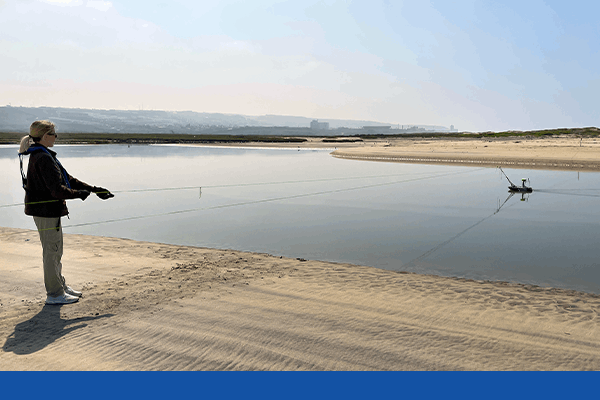
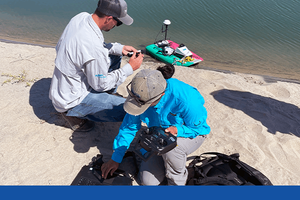
SDSU student Callie Summerlin conducts a transect measurement with the SonTek-RS5. The process was conducted by various members of the survey team throughout the entire tidal cylce to asses the flow of water (and pollutants) within the estuary.
Xue Fan, senior application engineer for SonTek, says her company is deeply committed to introducing students to hydrology, from elementary school through university and graduate levels.
"In the elementary schools, we teach the water cycle and water resources, and how we measure water cleanliness," Fan says. "We're also really seeing an uptick in university students who get exposure to modern instrumentation in hydrology, which is still up-and-coming. It's so important to expose these students to as many different instruments as we can, whether they're our instruments or others, because they're the ones who in 10 or 20 years will be making the decisions about water resources for all of us. They need to know what's out there—what methods, what instruments, what they can have at their fingertips as they make those decisions."