SonTek RS5

PriceRequest Pricing

SKURS5-STD-PK1


Want to know what the discharge data collection buzz is about - you’re at the right place! The SonTek-RS5 is the world’s most compact and robust ADCP for collecting river, stream, and canal discharge data. The RS5 is small yet powerful. When paired with the custom-designed HydroBoard II Micro and SonTek-RTK, you will be ready to quickly collect the highest quality water velocity and flow measurement possible regardless of where your environmental water monitoring takes you.

  • Overview

    Packed with All the Features, You Expect
    The SonTek-RS5 comes loaded with advanced data collection capabilities, high-precision data quality, and flexible deployment options customers have grown used to with SonTek ADCPs over the years.

    Acoustic Doppler Current Profiling System adcp discharge velocity data

    • Vertical Acoustic Beam: Superior channel definition for the most accurate cross-sectional area for discharge applications. Measures the depth directly under the system and extends maximum discharge depth if bottom-tracking is out of range. 360º compass and two-axis tilt sensor
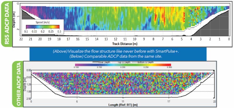
    • SmartPulse+®: An intelligent algorithm utilizing Pulse-coherent and Broadband acoustic profiling that automatically adjusts based on conditions—reliable bottom tracking and velocity profiling in water depths shallower than ever. Visualize velocity data like never before with cell sizes down to 2.5 cm.
    • 360º compass and two-axis tilt sensor: Reports vessel heading and magnetic error and compensates for motion due to surface conditions. The tilt sensor uses pitch and roll to correct depth and velocities.
    • RTK GPS (Option): Ultra-precise positioning as an alternative to bottom tracking in moving beds or other difficult situations. Geolocate each sample (or ensemble) during measurement. Corrections are sent from the SonTek RTK base station or a local NTRIP.
    • DGNSS (Option): Integrated DGNSS smart antenna for position as a backup or alternative to bottom tracking in moving bed or other challenging conditions.

    Acoustic Doppler Current Profiling System In River In Naples Florida

  • Specifications
    Specifications  
    Water Velocity Profiling
    Profiling Range

    0.1-6 m (*1)

    Velocity Range ±5 m/s
    Accuracy

    1% ±0.002 m/s

    Resolution 0.001 m/s

    Number of Cells

    Up to 128

    Cell Size

    2.5-30 cm

    Data Output Rate 1.0 Hz
    Bottom Tracking

    Depth Range 0.1-6 m (*1)
    Accuracy (*2) 1% ± 0.002 m/s
    Resolution

    0.001 m/s

    Depth Measurement
    Range 0.1-6.0 m (*1)
    Accuracy 1% ±0.005 m
    Sensors
    Temperature Sensors Resolution: ±0.01°C
    Accuracy: ±0.5°C
    Compass/Tilt Sensor Range: ±180° Pitch/Roll, 0-360° Heading
    Heading Accuracy: ±2°
    Pitch/Roll Accuracy: ±1°
     
    Transducers  
    Total Number Five, 3.0 Mhz
    Beam Angle

    25°

    Beam Width
    Bandwidth

    25%

    Battery Characteristics

    Input Voltage

    3.3-4.2 VDC

    Power Source - Li-Ion

    1x size 18650, Tenergy, Type 30016-04, 3.7Vdc, 2600mAh

    Battery Life - 1 x size 18650 Seven hours of continuous use, typical settings (*3)
    Power Consumption

    1.0 W (Average)

    Dimensions 19.2 mm x 69.7 mm
    RTK Rover Battery Life 1 x size 18650

    5 hours continuous use, typical settings

    RTK Base Station 1 x size 18650 14 hours of continuous use, typical settings
    Communications
    Radio Protocol

    Bluetooth Low Energy (BLE5)

    Range 100 m
    Bluetooth Compliance FCC Part 15, FCC ID: XPYNINAB30
    ISED Certification: 8595A-NINAB30
    Environmental
    Operation Temperature -20° to 70°C (-4°F to 158°F)
    Storage Temperature 20° to 70°C (-4°F to 158°F)
    Storage with Battery Temperature -20° to 45°C (-4°F to 113°F)

    RS5 Physical Properties

    Dimensions - TB-Micro
    80 cm (31.5”) x 46.5 (18”) cm
    x 15 cm (6”)
    Weight in Air - TB-Micro 4.2 kg (9.3 lbs)

    Dimensions - RS5 Unit

    24 cm (9.5”) x 5 cm (2.2”)

    Weight in Air - RS5 Unit 0.45 kg (1.0 lbs)

    Weight in Water - RS5 Unit

    0.15 kg (0.33 lbs)

    Waterproof Rating IP-68 with connectors in use or capped

    DGNSS

    Horizontal RMS SBAS (WAAS): <0.3 m (0.98 ft)
    2DRMS SBAS (WAAS): <0.6 m (1.96 ft)
    Frequency

    Multi-frequency, multi-constellation

    GNS3M Atlas Subscription

    Activate through manufacturer's App

    SonTek-RTK

    Horizontal Accuracy (Quality 4) < 0.02 m
    Vertical Accuracy (Quality 4) < 0.04 m
    Frequency

    L1C/A, L2C, Multi-GNSS

    Base-to-Rover Range

    250 m Line of sight


    *Additional notes
    1 Maximum range will vary with environmental conditions.
    2 Bottom velocity accuracy.
    3 When Using provided SonTek USB radio with antenna.

  • Accessories

    RS5 Power Supply

    Power Supply

    RS5 Bluetooth USB Radio

    Bluetooth USB Radio

    RS5 Antenna

    2.4-GHz antenna (2 dBi)

    RS5 Battery Charger

    Battery Charger

    RS5 GNSS Antenna Interface Cable

    Antenna Interface Cable

    RS5 Rechargeable Battery

    Rechargeable Li-Ion Batteries

  • Software

    RSQ: Visualize and Process Data Like Never Before!

     RSQ is a modern and user-friendly software interface. One measurement file includes all the data and metadata you need for each measurement. Export data to formats for Excel, Matlab, Google Earth, Kisters, and AGILA. Do more with less time utilizing improved site templates. Experiment, learn, or teach in the office or conference room as though you were in the field with the option to playback recorded files simulating live data collection. Flexibility is key with RS5.

    WITH RSQ, YOU CAN:

    • Collect both moving boat or stationary measurements
    • Connect to Network RTK (NTRIP) within the network range
    • Use GNSS to calculate the distance between stations for stationary measurements
    • Run and apply Extrap (USGS) to both moving boat and stationary measurements
    • Sub-section moving boat transects and recalculate discharge
    • Choose beam switching (3-beam solution) when one beam shows interference 
    • Process *.riv/*.rivr files from SonTek’s M9 or S5
    • Save data on a PC, external drive, or network
    • Custom file naming option
    • Select between GNSS or built-in magnetic compass for heading

    adcp data

    Get the Software and Firmware

  • Video

    Day in the Life of a Hydrographer, with Kevin Labbe

    Take a look at a day in the life of Application Engineer, Kevin Labbe as he helps researchers from the University of Georgia learn how to best use the SonTek RS5 ADCP, YSI's EXO2 multiparameter water quality sonde, and other instrumentation in the estuaries of Little St. Simons, Georgia.

You may also need

SonTek CastAway-CTD

Handheld Deployable CTD

Request Pricing

SonTek-IQ Series

Flow Monitor

Request Pricing

SonTek-SL Series

Water Velocity and Level Monitor

Request Pricing