Capturing reliable discharge data in complex environments
Introduction
Accurate and repeatable flow measurements in rivers, channels, and floodplains are critical for managing flood risks, protecting infrastructure, operating hydropower systems, and environmental monitoring. However, collecting high-quality data in dynamic or hazardous environments often presents significant logistical and safety challenges. Traditional approaches, such as deploying manned boats or relying on bank-based instruments, can be costly, time-consuming, and, in some cases, unsafe.
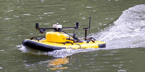
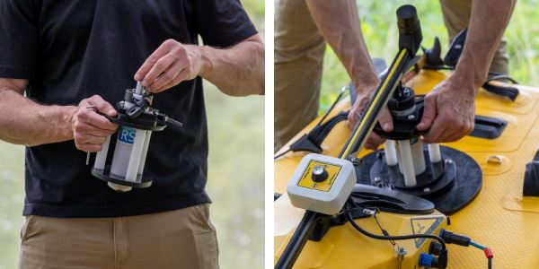
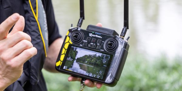
The Surfbee surface water vehicles are specifically designed for use with Acoustic Doppler Current Profilers (ADCPs), including the SonTek-RS5 and SonTek-M9, bringing a new level of autonomy, precision, and safety to discharge measurements and acoustic surveys. Surfbee vehicles also have the ability to equip the YSI EXO Sonde to collect water quality data, though the following cases focus on discharge. With on-board Global Navigation Satellite System (GNSS) receivers for navigation and heading, live camera streaming, and real-time adaptive speed and heading control, Surfbee vehicles can measure high-resolution transects with exceptional precision and repeatability—even in difficult flow conditions or hard-to-reach locations.
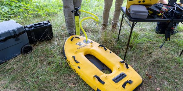
Surfbee is available in two models: Flow Seeker and Flow Scout. Flow Seeker is maneuverable and fast with three underwater thrusters, readily portable due to its inflatable hull, and designed for a wide range of gauging stations. Flow Scout also features three thrusters and an inflatable hull, but excels in shallow waters and is even capable of lateral movement for highly precise navigation.
Two recent case studies in Thailand, conducted in collaboration with government agencies, demonstrate the capabilities of Surfbee vehicles in both urban floodplain monitoring and hydropower dam discharge assessment.
Case study 1: Flood management in Bangkok’s urban and rural waterways
Bangkok’s urban waterways and surrounding floodplains require frequent and precise flow monitoring. The Bangkok Metropolitan Authority and the Royal Irrigation Department, two key stakeholders responsible for managing both infrastructure safety and flood mitigation, were trained to use the Surfbee Flow Seeker in environments ranging from narrow canals to wide flood-prone rivers that can experience rapidly changing flow conditions such as flash floods. These areas are critical for public safety and infrastructure monitoring, and demand a flexible, easy-to-deploy solution.
Flow Seeker was deployed in a channel that spanned roughly 200 meters across—a distance that rendered cabled systems unusable and would typically require a manned vessel for ADCP operation, which can be costly, inefficient, and potentially unsafe.
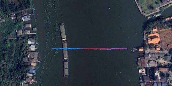
Figure 1. Transects (blue – GNSS track and red – Bottom Track) performed by Flow Seeker across a channel more than 200 meters wide.
With Flow Seeker, operators were able to measure two complete transects of the cross-section using the SonTek-M9 ADCP. The transect datasets delivered nearly identical discharge values, averaging 1,564.8 cubic meters per second, and revealed a channel bottom depth of up to 15.8 meters. The straightness and overlap of GNSS-tracked transects illustrate precise auto-navigation and high positional accuracy. Each profile was completed in approximately eight minutes—demonstrating both the efficiency and repeatability of the system.
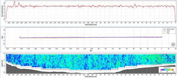
Figure 2. Vehicle speed, distance, and discharge profile data collected by Flow Seeker during a transect. Notice the steady boat speed maintained throughout the transect.
Once Start Edge and End Edge waypoints were defined, Flow Seeker followed its path with remarkable consistency, thanks to its onboard GNSS and adaptive speed control, which maintained a steady 0.5 meters per second across the entire cross-section. Even when conditions changed or obstacles like floating debris appeared, the user has the ability to manually adjust course, pause, or reroute the defined path. Live input from the onboard camera helped operators maintain awareness while also ensuring measurement endpoints were visually confirmed even when the vehicle was out of sight.
Operators noted the significant advantage of being able to store waypoints for future visits, enabling data collection along the exact same transect over time. In wide channels where line of sight is lost, the ability to see the vehicle’s live location over offline background maps was essential, particularly in remote areas without internet access. In addition, Flow Seeker’s high-accuracy GNSS is directly integrated with the M9, eliminating the need for additional antennas or receivers. Depending on the user’s location, GNSS quality can be corrected using Differential or Real-Time Kinematic (RTK) methods which utilize a physical base station—or potentially internet-based RTK corrections via NTRIP—for more accurate navigation.
These features provided a complete, flexible solution for Bangkok’s urban and rural discharge monitoring, allowing teams to collect precise data where previously difficult or impossible.
Case study 2: Dam discharge measurement for hydropower management
The second deployment took place downstream of a hydropower dam managed by the Electricity Generating Authority of Thailand (EGAT). Monitoring discharge during active reservoir releases is critical, for both power generation optimization and downstream safety. However, fast-moving flows make the use of traditional, manned long-tail boats both dangerous and unreliable for precise discharge monitoring.
Flow Seeker was used to navigate a post-dam release site with high flow conditions across a 100-meter-wide channel, while providing safety, precision, and speed for operators onshore. Despite flow velocity varying dramatically throughout the cross section—from near-zero at the banks to over 2 meters per second at the center—Flow Seeker held a straight, stable line on each transect. Its real-time course correction allowed it to adapt to the changing flow conditions, ensuring consistency and data quality.
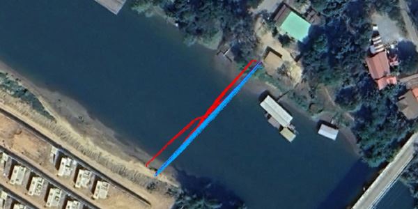
Figure 3. Transects (blue – GNSS track and red – Bottom Track) performed by Flow Seeker across a channel with highly variable flow. Note the deviation in bottom track ship tracks, indicating a moving bed at this site.
One of the most notable findings in this deployment was the presence of a moving bed, which can significantly bias bottom-tracked discharge values low. In such conditions, GNSS tracking becomes essential. Flow Seeker’s integrated GNSS not only provided accurate positioning, but also allowed operators to rely on absolute movement across Earth’s surface rather than potentially compromised bottom references.
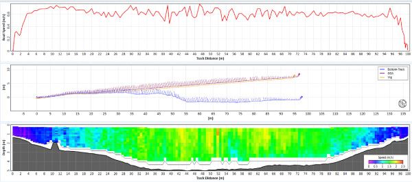
Figure 4. Vehicle speed, distance, and discharge profile data collected by Flow Seeker during a transect. Notice the repeatability of the transects despite the large variation in velocity.
Once deployed, each transect was collected in about three and half minutes and produced highly consistent discharge values, averaging 447.8 meters cubed per second.
The site, located near bridges and ferrous infrastructure, also highlighted another key vehicle feature: GNSS compass heading. Unlike traditional magnetic compasses that are prone to interference, Flow Seeker’s standard GNSS-based heading system ensured accurate orientation throughout the measurement—particularly important when navigating close to structures or conducting repeat transects.
With onboard video streaming and waypoint control from the remote interface, operators were able to adjust positioning on the fly to identify ideal cross sections that would be inaccessible or invisible from the bank. These features combined provide the greatest amount of flexibility for the best quality measurement possible—something that was never possible with other vehicles or hydrological methods.
Flow Seeker produced repeatable discharge values across challenging transects, saving time in the field and reinforcing the reliability of the system under complex hydraulic conditions.
Conclusion
Surfbee vehicles have proven to be versatile and dependable tools for surface water discharge measurement in even the most challenging environments. In Bangkok’s urban floodplains, it delivered repeatable, high-resolution data across wide, inaccessible channels. Downstream of a hydropower dam, it provided a safe and precise solution for measuring fast-moving releases—while accounting for moving bed conditions and infrastructure interference.
By combining autonomous navigation, high-precision GNSS, live video, and adaptive control, Surfbee vehicles allow water resource managers to gather better data with less effort and less risk. It empowers agencies to monitor infrastructure, respond to changing flow conditions, and build long-term datasets with confidence and repeatability.