Creative use of drones helps water quality experts monitor dangerous pit mine sites
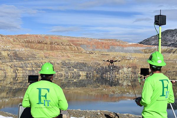
Hovering just a few meters over the surface of a mile-wide lake, the remote-controlled octocopter steadily lowers its multiparameter sonde into the turquoise water.
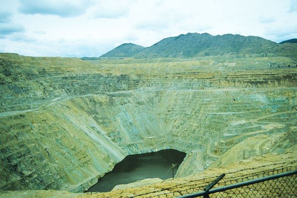
With a pH of 4.3, water in the Berkeley Pit in Butte, Montana, is about as acidic as tomato juice. Steep, eroding slopes of decomposed granite ring the manmade lake. The raveling slopes have the potential to create significant waves on the lake's surface, making the Berkeley Pit too dangerous to sample with staffed boats.
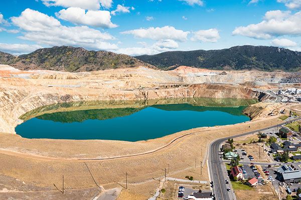
Aerial view of the Berkeley Pit, which reaches 255 meters (836 feet) deep and holds 182 billion liters (48 billion gallons) of toxic water.
Enter the Water Sampling Platform, or WaSP, an ingenious drone equipped for water sampling by Ian Fairweather of Fairweather IT (FIT) and AppSciTec.
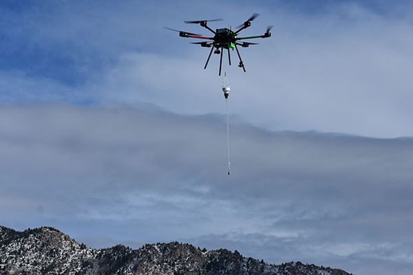
High-strength fishing line spools out of the WaSP's modified deep sea fishing reel as the sonde measures pH, temperature, depth, dissolved oxygen (DO), oxidation-reduction potential (ORP), turbidity, and conductivity as it sinks to the bottom of the lake more than 250 meters (800 feet) below.
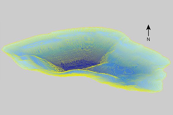
Map showing the depth contours of the Berkeley Pit, a former open-pit copper mine filled with acidic water.
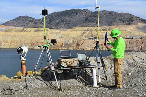
Battery life is precious and short, especially on a heavily loaded drone, so Fairweather and his equipment operator, Brandt Winkelman, focus on efficiency to reach the sampling location, capture the measurements, and fly the WaSP back to their rocky overlook within 20 minutes.
Richest hill on earth
Fairweather and his team have conducted up to eight water quality profiling flights a day with the WaSP.
The Berkeley Pit is the carved-out remains of "the richest hill on earth," a massive open-pit copper mine from which approximately one billion tons of rock were removed and processed to capture the rich copper from its ore.
Mining ceased at the Pit in 1982, and its owners shut down the huge pumps that kept the Pit and the old network of underground mines beneath it dry. By 1983, water appeared in the bottom of the excavation site as groundwater welled up and rain flowed down, collecting steadily to create a lake approximately 255 meters (836 feet) deep.
That water started out with a pH of 2.3, similar to vinegar. Through the decades, sending lime back to the lake has helped raise the pH of the retained water.
Over time, the lake has changed colors dramatically as different minerals precipitated out at various levels of acidity.
To keep Pit water from rising to a level that would threaten the surrounding alluvial aquifer, the U.S. Environmental Protection Agency (EPA) also approved a plan to pump out some of the water, treat it to surface water standards, and release it into Silver Bow Creek.
"The Berkeley Pit is an immense body of water—there's roughly 182 billion liters (48 billion gallons) in there," says Loren Burmeister, liability manager for the Atlantic Richfield Company in Butte, Montana, which funds this initiative to measure geochemical parameters in the Berkeley Pit.
"There's occasional sloughing going on, there's materials being put in there, there's water flowing in there all the time. All those things, as well as meteorological events, lead to continual changes in the water body.
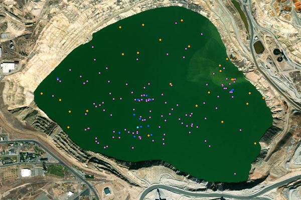
UAV Sampling Locations, marked for water quality (purple), sludge or Imhoff cone physical sample (orange), and Physical water sample (blue).
"All of these data collection efforts are really just to improve our understanding of the Pit, of what influences the Pit, of what's going in there so we can make informed decisions about how we implement our remedy," he notes.
"So, as we need to treat water, pump water, and discharge water, what are the characteristics of the water so we can do that effectively?
"Right now, we're working with other interested parties to explore whether we could extract dissolved minerals from the Berkeley Pit water," Burmeister adds.
Fairweather and his crew reel equipment all the way down to the bottom of the Pit.
He points out that studying the temperature and chemistry of the water column has revealed interesting insights into the dynamics of the huge site's water, including the fact that there is a seasonal turnover in the water as its temperature near the surface changes.
"There's been a lot of speculation of whether the Pit turns over or not," Burmeister says. "Profiling the Pit temperature and chemistry at depth allowed us to confirm that theory, that it does.
“It could affect where we're pumping from, though it hasn't yet. But if we found a chemocline—a chemical separation, maybe a certain level is richer in valuable metals, or a certain level is easier to treat—pumping from that level for treatment would make more sense.
“It's all about answering those questions that will make us more effective."
The WaSP takes to the air
For years, crews collected water samples from a pontoon boat on the surface of the Pit's lake, but it was eventually deemed too hazardous for staffed boats. Using helicopters was an unattractive alternative, given the additional hazards associated with manned flights, as well as the Pit’s position within a commercial airline route.
In 2017, Burmeister teamed up with Fairweather to find a safer, more efficient way to monitor water quality using drones in the Berkeley Pit and even more inaccessible former mining sites.
"They hired us to design this platform so we could safely collect water samples and water quality data from the shore without putting anyone at risk and to be able to do multiple samples in a day," Fairweather explains. "We've done up to eight flights in a single day collecting water quality profiles with a YSI EXO1."
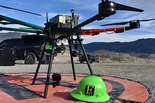
Watts Innovations PRISM octocopter.
Fairweather built the patented WaSP on a Watts Innovations PRISM octocopter, whose four arms each have propellers on the top and bottom of their motor assemblies.
With battery, reel and motor, two cameras, and a full payload—which can include an EXO1 Multiparameter Sonde, sonar bathymetric profiler, a filled water-sampling bottle, sediment-catching Imhoff cones, or a custom-made sludge sampler—the PRISM octocopter weighs just under the 25-kilogram (55-pound) limit that would otherwise require a switch to different licensing and regulations under the Federal Aviation Administration.
The three-speed motorized reel is a key feature of the WaSP. Flying with the sampling equipment tucked just under the drone body allows maximum flexibility and maneuverability compared to suspending the equipment at the end of a fixed 61-meter (200-foot) line, Fairweather notes.
The WaSP drone serves as a specialized aerial platform optimized for precise data collection and safe operation.
It also allows Fairweather and Winkelman to take samples to meet very specific requests from Burmeister and geochemist James Jonas—including reeling equipment all the way down to the bottom of the Pit. If equipment gets snagged, a guillotine cutter can set it free.
EXO1 in the mix
Fairweather points out that the YSI EXO1 Sonde has been part of the WaSP design from the very start.
"Honestly, the EXO is what Atlantic Richfield told us to get," Fairweather laughs. "We actually rented one and tested it on the WaSP prototype. We got good data with that, so we bought one so we could do all the calibration. It's worked great. We've also used an EXO1 on two of our USVs [drone boats]."
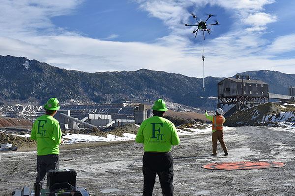
Samples are lowered to a “catcher,” where the team downloads data, rinses gear with distilled water, replaces batteries, and sends the WaSP back out for more.
Fairweather uses Xylem's HYPACK software to create a data matrix that combines bathymetric and water quality data with GPS location tracking, allowing the team to analyze surface geochemistry while studying site bathymetry.
"So we just have that data matrix with RTK GPS information, the depths, and all the chemical analysis that we're doing, which makes it really, really easy to collect and run," he notes. "You can view it all in the HYPACK shell. And we have a map of all the places in the Pit where we've collected data, so we don't have to have the sonde connected to the drone itself. It's just running autonomously.
“We start logging, hook it to the drone, and fly out to collect the data. We just log the data on the sonde, and when we get back, we pull all the data off."
After every flight, Fairweather and his team rinse the sonde and all other WaSP equipment thoroughly with distilled water.
Future improvements
The Berkeley Pit in 1984.
One of the tricky things about some open mine sites, Fairweather points out, is that flying a drone below their rim can make it difficult or impossible for drones to stay connected to enough GPS satellites to provide precise location information. That requires a skilled pilot to navigate and maintain the proper altitude for safe operation. It also makes it difficult to coordinate different data-gathering operations from a specific location.
Fairweather envisions upgrading the WaSP's GPS capabilities to a survey-grade system, then setting up a base station with a clear view of the sky and good line of sight to the drone. With corrections from the base station, the drone should be able to navigate accurately, return to specific sampling sites, and record precise location data, even if it can only maintain contact with a few satellites.
Another project is designing a sediment sampler to gather sludge from the bottom of the Pit. "Definitely more challenging than I originally thought it would be," says Burmeister.
Add that to the unusual challenge of flying a drone that is often far below the pilot rather than above.
"It's a unique flying environment," says Fairweather. That's an understatement about a landscape so vast it's hard to comprehend.
ADDITIONAL INFORMATION
Teamwork makes the drone work
Piloting an expensive, custom-outfitted drone over highly acidic water, cruising at an altitude well below the pilots' feet, and conducting water sampling operations is not for the faint-hearted. It also requires four hands, two very sharp minds, and a lot of communication.
Inventor and pilot Ian Fairweather describes a sampling mission with the AppSciTec Water Sampling Platform, or WaSP. He pilots the 24.5-kilogram (54-pound) system while equipment operator Brandt Winkelman handles the sampling functions. They see each other's readouts but operate on separate radio frequencies to prevent crossed signals.
Inbound samples are lowered to a "catcher" on the team. When the drone lands, the team downloads data, washes gear with distilled water, swaps batteries, and sends the WaSP back out for more.