How El Niño Impacts on Our Climate
While climate change and its pervasive impacts have recently occupied weather-related headlines, a different protagonist takes the stage this year—El Niño.
El Niño is a climate pattern tied to increased ocean surface temperatures in the eastern Pacific Ocean—along the west coast of South America—causing temperatures in the tropic and subtropical regions to be warmer.1
Originally discovered by South American fishers who noticed warmer than usual water off the coast of Peru, El Niño means “the little boy” or “Christ Child” due to the natural phenomenon occurring close to the holiday season.1

El Niño was discovered by Peruvian fishermen.1
Today, El Niño is a well-known and naturally occurring climate pattern that’s often misunderstood. This blog post serves to:
- Dissect the mechanics of El Niño and discuss its wide-reaching impacts on global climate patterns.
- Introduce the concept of a ‘super’ El Niño—a very strong El Niño event—that could form during the last few months of 2023.
- Describe the relationship between El Niño and climate change.
Background: Understanding ENSO
There is also a cooling phase similar to El Niño, La Niña, which ended in March 2023, with El Niño forming just a few months later in June.2 Both El Niño and La Niña are the ocean part of the El Niño-Southern Oscillation (ENSO) phenomenon.1
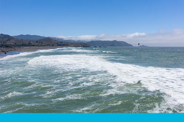
ENSO affects the surface water temperature in the Pacific Ocean.1
Overall, there are three phases of ENSO:
Neutral Phase of ENSO
During normal weather conditions—the neutral phase of ENSO—trade winds blow westward across the tropical Pacific, pushing warm water from along the coast of South America towards Asia and Australia. As a result, cold, nutrient-rich water rises in the eastern Pacific—a process called upwelling—lowering ocean temperatures and providing food for marine life and fisheries in South America.1
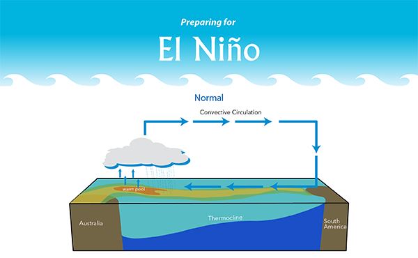
How the thermocline and surface water behave in the neutral phase of ENSO. Winds blow west across the Pacific, pushing warm water away from the coast of South America. This allows for upwelling to occur.
El Niño: The Warm Phase of ENSO
During El Niño, the trade winds become weak—and sometimes even blow towards the east—impacting the movement of warm water towards the western Pacific. The thermocline, the layer of ocean depth that separates warm surface water from the cold, deep water, is deepened and sometimes flattened out, not allowing upwelling to occur and negatively impacting the fishing industry off the west coast of South America.1 Ultimately, this causes ocean temperatures in the central and eastern tropical Pacific Ocean to rise.3
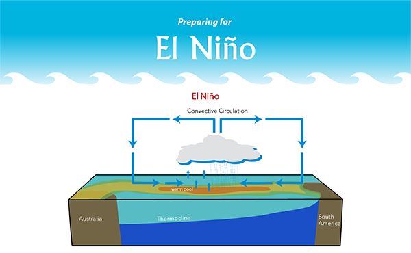
How the thermocline and surface water behave in the warm phase of ENSO. The winds become weak and sometimes blow east, while the thermocline flattens and the surface water becomes warmer off the coast of South America.
La Niña: The Cold Phase of ENSO
The opposite of El Niño is a cooling phase called La Niña, meaning “little girl” in Spanish. In this process, trade winds blowing westward across the equator intensify, pushing even more warm water away from the eastern Pacific than normal. Along the coast of South America, waters already cool during the neutral phase of ENSO become even cooler, increasing upwelling and improving conditions for fishing.4
General El Niño Weather Impacts
ENSO plays a significant role in the Earth’s weather. In addition to directly impacting ocean temperature fluctuations in the Pacific Ocean, it can change atmospheric circulation, causing changes in air temperature and precipitation.3
It should be mentioned that seasonal forecasting is much less precise than short-term weather predictions and can change as time goes on and the seasons change.5 El Niño predictions typically involve a range of scenarios and are not a 100% accurate forecast, adjusting with how El Niño changes.
During an El Niño event, heat is released from the ocean into the atmosphere, resulting in a general increase in global temperature. However, not all regions become warmer, and impacts can vary from one El Niño event to another.7
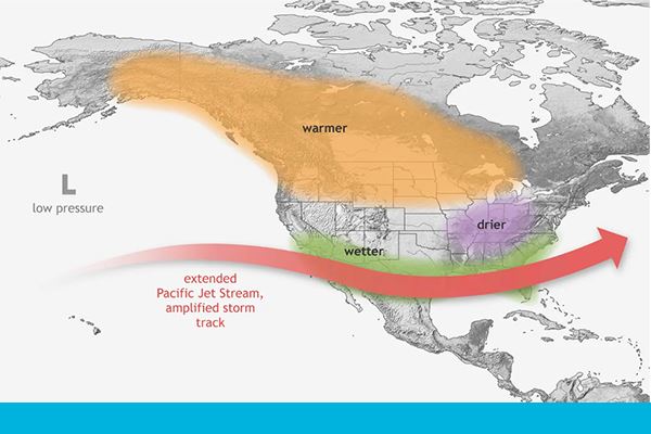
During an El Niño event, North America may expect warmer, drier, or wetter weather in the winter, depending on location.6
While El Niño is ongoing in the northern hemisphere’s winter, warmer temperatures often occur throughout the northern portions of the continent, drier conditions occur in the midwestern U.S., and wetter weather persists in the south.6
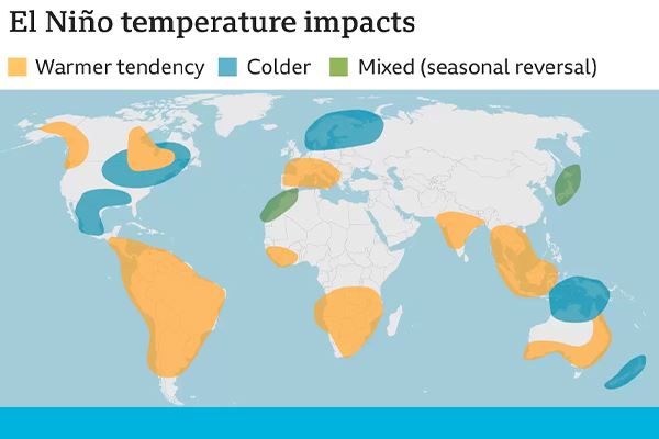
Globally, temperature is impacted differently during the northern hemisphere winter when in El Niño.7
Globally, during El Niño events, it is expected to be colder in parts of the U.S. and Mexico and warmer in South America. It will also be warmer and drier in parts of Africa and Australia.7 El Niño causes droughts in some places, like Indonesia and Australia, and heavy rainfall in others, like Peru and Ecuador.1
While portions of the U.S. and Mexico may see a wetter season, Asia, Australia, and Africa could see a drier season.7 El Niño has different effects on the weather over the globe, and the opposite effects occur during La Niña.
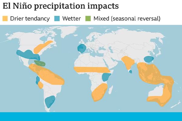
Similar to the North American map, precipitation is globally impacted differently when in El Niño.7
Timing and Predictability
Typically, El Niño and La Niña last several months every few years.8 La Niña events may last up to three years, unlike El Niño, which usually lasts no more than a year. However, it’s worth noting that these are general patterns, and exceptions can occur. El Niño and La Niña most often peak during the Northern Hemisphere winter.4
The last La Niña lasted for three years, ending in March 2023.2 The current El Niño is expected to last through the northern hemisphere’s winter, hopefully ending in February 2024 and bringing surface water temperatures in the eastern Pacific back to normal.9
There is no regular cycle for El Niño, making it nearly impossible to precisely predict when one may form and the exact weather impacts in a particular region. However, scientists do have models and indicators that help predict their onset to some extent.
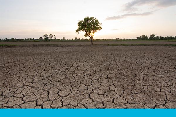
Cracked soil is an effect of climate change, specifically higher temperatures.
Specific 2023 Impacts
There have been record-breaking temperatures since El Niño formed in June 2023.8 As El Niño continues, we will see rising temperatures, and the 2024 heat season could be even worse.11 El Niño—combined with the impacts of climate change—means we could see the warmest year and seasons ever.6
El Niño may have played a role in the formation of Hurricane Hilary, which impacted the western U.S. on August 16-21, 2023.13 It’s uncommon to see a hurricane appear in the Pacific Ocean along Mexico and California. The category 4 hurricane would likely not have been possible without the Pacific waters being warmer than average; these conditions allowed Hurricane Hilary to intensify rapidly.12
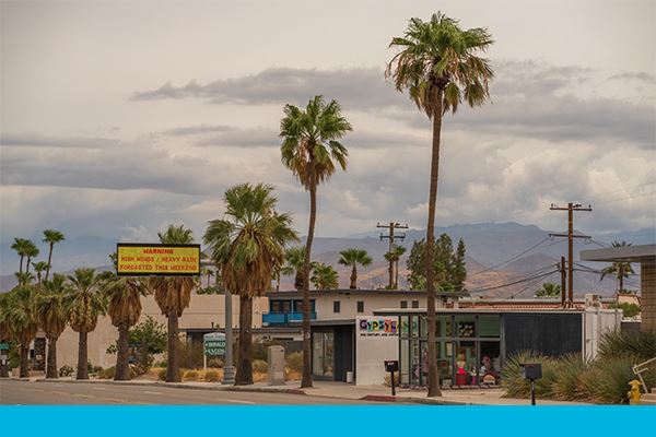
Los Angeles prepared for Hurricane Hilary with warning and safety signs. It was the first time Southern California issued a tropical storm warning. Nevada, Oregon, Idaho, and Montana’s tropical storm rainfall records were broken.12
After nearly three years in La Niña, El Niño could cause the temperature in the upcoming seasons to be record-breaking. El Niño could become a super El Niño—a very strong El Niño event—that could produce damaging weather extremes globally.5 Some places in the U.S. could see much greater rainfall and snowfall; if we pass into “super” territory, this winter could turn from mild to intense.5

During the last super El Niño in 2015, Baltimore, Maryland, saw 29 inches of snow.5
Relation to Climate Change
ENSO is a natural phenomenon. In contrast, changes in climate since the 19th century have primarily been driven by humans through greenhouse gas emissions. While they are not directly linked (i.e., one does not cause the other), climate change can act to exacerbate or mitigate the impacts of El Niño.14
Oftentimes, global temperatures continue to rise for a year after El Niño develops, meaning the effects of the current El Niño will continue to be felt in Spring 2024. With this in mind, we should still prepare for a warmer 2023 winter.10
Without the impact of climate change, temperatures would eventually return to normal after El Niño ends. However, an overall increase in global temperatures due to climate change and El Niño could result in record-breaking temperatures in the near future. In fact, 2023 could end up as the warmest year on record.10
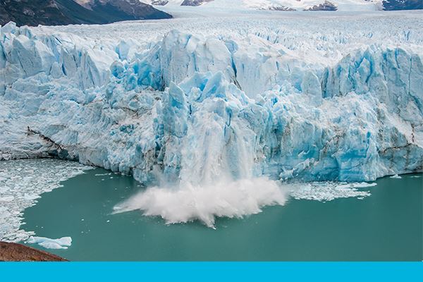
Glacial melting is inherently tied to a warming climate. El Niño could drive temperatures even higher.
From 2020 to 2023, La Niña conditions prevented global temperatures from increasing as much as they would have during the neutral or El Niño phases of ENSO. La Niña, the cooling phase of ENSO, had three consecutive cycles, causing cooler waters to rise to the surface in the eastern Pacific. With El Niño following a long stint of La Niña, the increasing temperatures are expected to hit a new record in the next five years.7
To make matters worse, El Niño plays a role in increasing concentrations of carbon dioxide (CO2)—the primary greenhouse gas emitted through human activities.15 In tropical regions, plants absorb a tremendous amount of CO2. When El Niño causes drought conditions in these regions, plants absorb less CO2, while wildfires can release it into the atmosphere.7
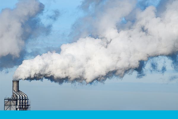
The concentration of carbon dioxide—the primary greenhouse gas emitted through human activities—can increase during El Niño.
Conclusion
El Niño’s impact is as profound as it is widespread, affecting ecosystems and communities across the globe. By deepening our understanding and anticipation of its patterns, we better equip ourselves to mitigate its effects. As we navigate the changing climate, our foresight and preparedness are crucial in steering a course towards resilience and adaptability.

Sources
1. National Geographic, El Niño
4. National Geographic, La Niña