Want the Best Water Quality Data?
It’s all about location, location, location!
Site selection is a critical factor in collecting representative water quality data—sometimes more so than the sensors used to make the measurements. Many factors go into selecting the perfect location to take measurements in aquatic environments, whether for spot/grab sampling, continuous monitoring, or profiling a water column.
Shaken, Not Stirred?
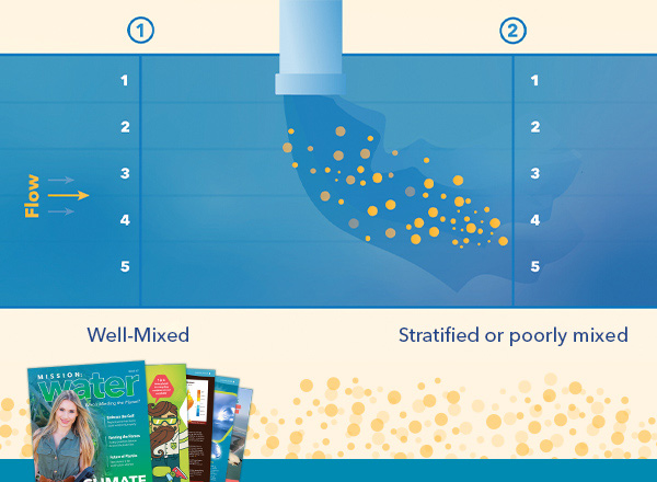
First, it is essential to choose a site that is well-mixed, especially when working in rivers and streams. “Well-mixed” means that constituents at a given location are similar across the remainder of the body of water.
To verify that a river or stream site is well-mixed, YSI recommends collecting a series of water quality readings in a horizontal cross-section of the water body; and if the channel is deep enough, they should be collected at various depths as well. It is vital to ensure mixing at all water levels (storms and baseflow) in addition to season (winter versus summer) because these changes can have significant effects on the water body.
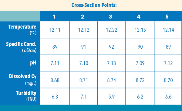
Cross-section Points: This is an example data set for well-mixed samples. (For illustration only.)
Once you confirm a location is well-mixed, recorded changes can be more confidently expected to have occurred across the entire system, leading to better analysis of trends based on time, seasonality, precipitation, and so forth.
Stratification (layers of water with different chemical/physical properties) and poor mixing can tell a story about changes in the water body, but for the most accurate water quality study, sampling should be done at a well-mixed location. If monitoring is to occur in one of these types of locations, it is recommended to monitor more frequently or add additional equipment to keep track of conditions.
Keep it Consistent!
Maintaining a consistent sampling location is also vital to collecting the best data. If a sample is collected at a different location every time, there could be differences in data that would significantly impact any analysis. For example, sampling upstream of a wastewater effluent pipe on one trip to the field and downstream the next can wreak havoc on your data integrity.
Overhead view: A river with two cross-section examples. Which are you trying to measure – natural or point-source discharge?
Similarly, if measuring in a reservoir or deep body of water, it is important to measure at a consistent depth but this may mean two different things depending on the project. For example, one project may call for measurements at a consistent depth of 1m from the surface for ecological purposes, whereas another project may call for measurements at 2m from the bottom because that is where the drinking water intake pipe is located. It is important to know the goals of the project in order to determine the best sampling location.
Unique Challenges
When collecting grab samples and setting up instruments for autonomous data collection (either in pipes or suspended from buoys), it is essential to install the measurement device in a similar location in the water column each time. There can be drastic differences in recorded values if a water quality sonde is placed on a streambed or seafloor versus suspended in the column, especially in areas where the substrate beneath the instrument is composed of fine sediment.
Fine particulate can accumulate around instrumentation installed on the streambed which could cause elevated readings of parameters like turbidity or nitrate. The instrumentation would also be more susceptible to being buried during high flow events. If an instrument is suspended higher up in the column, there is less chance of the equipment being buried and there is also a higher chance of being a more representative sampling location when compared to the cross-section described earlier. However, if the bed sediment dynamics are more of interest, perhaps mounting on the streambed is of the most interest!
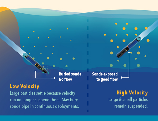
Poor flow to sensors due to sediment build-up is an important consideration for long-term monitoring.
Go With the Flow
Water quality instruments do not require a particular flow rate to collect meaningful data but there are some key velocity-based judgments to take into consideration. If an instrument is installed in an area of no-to-low flow, it could experience increased sedimentation and biological growth during long-term deployments.
During spot sampling trips, if the velocity is too low, it may take an instrument an extended period to equilibrate to conditions, especially if the fluid that the sensors are transported and stored in is significantly different from the real water conditions. For example, when sampling for pH in low ionic strength waters, try to avoid transporting the sonde in pH buffer and use tap water instead. Remember to store the sensor properly again after the sampling trip based on the expected duration of storage. See the User Manual for your instrument for guidance on storage.
On the other hand — if sensors are used in an area of turbulent flow, bubbles in the sample can cause interferences in your measurements, reflected as abrupt spikes in the data of varying degrees. Do your best to find a location that avoids this issue entirely.
Safe and Sound
It is also essential to consider the possible high water levels and velocities that may make a site unsafe for sampling teams to enter at times. For a safe sampling experience at all water levels, locations with bridges should be considered, or engineering controls, such as a pulley system across a channel, should be installed to allow easy access.
It is not enough to say that a sonde is retrievable; the sonde pipe also has to be able to be maintained to aid in fouling reduction. A technician must be able to clean the inside and outside of the pipe thoroughly to avoid any influence from plant growth or sediment accumulation on the instruments. With some sites (such as springs in Florida) that fluctuate 10-15 feet in very little time, it is important to know the site and mount the equipment in a manner that is safe to access at all water levels. If this cannot be accomplished, simply make note of what water levels the equipment can be accessed at so that technicians know ahead of time if equipment can be serviced that day or not.
Larger Systems
Finally, many water quality instruments are deployed from buoys or on platforms. It is essential to keep the instruments away from marine traffic to prevent damage to the equipment or the vessels traversing the area. Buoys and platforms may need to be set up further to one side of a channel than the other to allow ships to pass by easily.
With these types of installations, it’s also vital to understand the overall depth of the water body. When deploying a buoy, different depths and velocities require different mooring options to keep them safely in place— and not all buoys can be moored the same way!
Large profiling systems can be mounted on a buoy or a platform. For these, it is also important to know the maximum water depth for the proper setup and programming of the instruments onboard. If the depth is incorrectly set up for the site, you may end up collecting sediment data from the bottom of the water body rather than the valuable data you need.
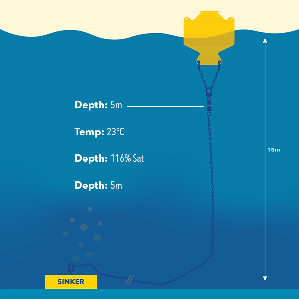
This is an example of a single-point mooring data buoy.
Avoid Headaches
Spend more time upfront to find an optimal monitoring or sampling site location. You’ll save yourself and your colleagues many headaches, and thank us later with just a bit of reconnaissance work!
We would love to hear more about your experiences selecting sites for your instrumentation. Please share your pictures and stories with us on Facebook and Twitter!
You may also be interested in our on-demand webinar Gearing Up for Fieldwork.