Water Quality Mapping at Hydroelectric Impoundments
Specializing in environmental research, mapping, and reporting, Affiliated Researchers utilized advanced water quality monitoring instruments, GPS technology, and hydrographic software to accurately measure and map important water quality parameters within hydroelectric impoundments.
These advanced technologies provide for the integration of highly accurate GPS positioning with sensitive YSI water quality monitoring instruments to enable the collection of tens of thousands of critical water quality parameters and provide for the accurate measurement, mapping, and documentation of the water quality.
To assist with a hydroelectric company’s compliance with the Federal Energy Regulatory Commission monitoring requirements, Affiliated Researchers helped develop, implement, and manage a water quality monitoring program at 4 hydroelectric impoundments. The monitoring program provided a greater understanding of the water quality stressors and dynamics within the impoundments.
Within the impoundments, areas of nonpoint source pollution included the nearshore environments along densely developed housing tracts. These areas of concern were thought to be sources of high levels of nutrients entering the aquatic environment, attributed to antiquated septic systems and landscape fertilizing.
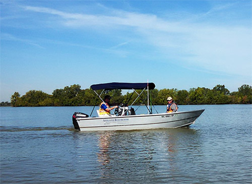
Affiliated Researchers utilized its 16’ shallow-water survey vessel to navigate the nearshore environments and collect more than 100,000 in situ water quality measurements within the impoundments. Advanced hydrographic software from HYPACK was used to integrate a Trimble SPS855 RTK-GPS with a YSI multiparameter water quality sonde.

An onboard hydrographic computer is used to combine the in situ water quality data collected by the sonde, with accurate geo-spatial positions collected by an onboard RTK-GPS.
Advanced hydrographic software was used to compile the collected water quality and geo-spatial data, and develop these compiled data sets into contour-type environmental surveys.
Using this water quality mapping procedure, Affiliated Researchers was able to measure and map the respective concentrations of non-source water quality parameters to include dissolved oxygen (DO) and nitrates (NO3) within these impoundments.
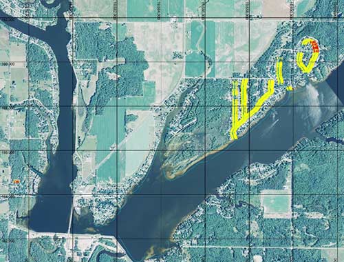
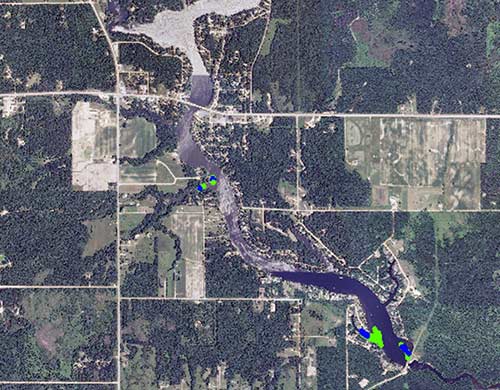
The collected data were averaged, and then sorted according to significance per Standard Deviations (StDev) from the mean. As a means of determining the locations within the impoundment of statistically significant water quality conditions, accurate maps on scaled aerial photograph backgrounds were developed using advanced hydrographic software. Water quality mapping was developed to show the locations where statistically significant concentrations of nitrates and DO occurred (Figures 1 and 2).

Figure 1 shows the mapping of significantly elevated concentrations of nitrates, in terms of 1-2 StDev from the mean (yellow) and 2-3 StDev from the mean (red).

Figure 2 shows the mapping of significantly depleted levels of DO, in terms of 2-3 StDev (green) and >3 StDev (blue).
Data collected using the described methods and equipment provided Affiliated Researchers’ Scientists and Resource Managers with a clearer understanding of the non-point source pollution that effect DO and nutrient concentrations within the impoundments.

Since 1990, Affiliated Researchers has become a recognized leader in providing high-quality environmental and technical services for municipalities, public utilities, environmental-engineering firms, Fortune 500 companies, energy companies, and the State and Federal agencies to include the DOD, NOAA, USACE, USCG, USEPA, and USFS. Affiliated Researchers provides its services nationwide. Please contact our specialists to discuss your project requirements.

Additional Blog Posts of Interest
Bathymetric Surveys and Profiling Data Benefit from AUVs
The Evolution of Water Quality Monitoring [Free eBook]
Jag Ski Creates Versatile Platform for Mobile Bay Study