Large-Scale Floodplain Restoration Project
At 7,100 acres, Emiquon Preserve is one of the largest floodplain restoration projects in the United States outside the Florida Everglades. Located within the Upper Mississippi River system, Emiquon was, until very recently, a vast expanse of plowed fields and rotating crops in the country’s farming heartland. Beginning in 2007, The Nature Conservancy (TNC) began to restore Emiquon from agricultural land to floodplain wetlands.
100 years of agriculture, while providing food, has taken its toll on the region’s ecosystem. Natural water flow patterns have been disrupted by levees on the Illinois River (a tributary of the Mississippi). A rich and varied floodplain – comprised of co-existing slices of prairie, meadow, marsh, shrubbery, forest, and shallow water pools – has mostly disappeared. And with it the plants, animals, birds, and fish that called this habitat home.
One group decided to undertake a momentous reversal of the past century’s practices and return this area to its natural state. “Emiquon is a premiere demonstration site for the Conservancy’s work on the Illinois and Mississippi Rivers. Research and management of this large restoration project may ultimately help us guide other floodplain river restoration efforts around the world,” notes Maria Lemke, an aquatic biologist with TNC. She and her colleagues are the core team guiding this renaissance.

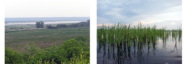
Both photos: Thompson Lake. Former farmland adjacent to the lake was returned to its natural floodplain habitat and aquatic vegetation was re-established.
To begin with, TNC purchased all 7,100 acres of Emiquon. “We enrolled it in the Wetlands Reserve Program, a federal program that pays landowners to convert farmland back to natural habitat1. Our partner in this has been the [USDA’s] Natural Resources Conservation Service, which purchased an easement on most of the acres and helped us with the financing,” Lemke says.
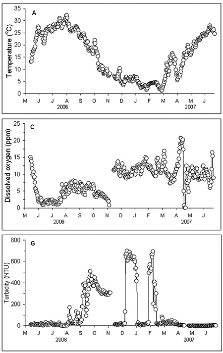
Next comes the science part. 2006 was the last year that crops were planted in Emiquon. TNC set up three monitoring stations within the preserve to assess water quality and gather baseline data. The data help TNC monitor its Key Ecological Attributes (KEAs) and help measure the conservation progress.
“KEAs are objectives or targets within our restoration plan,” explains Lemke. “They include specific items such as underwater irradiance, water depth, hydrology, and fish reproduction. What this means is, as we try to reintroduce aspects of the original habitat, like submersed and moist-soil vegetation, fish, and shorebirds, we are measuring the water quality for key indicators that can tell us if the water will support and promote the growth of these elements.”
Monitoring stations are equipped with water quality instruments from YSI. The project utilized 6600 sondes (EXO sondes would also be ideal) at the stations to measure water depth, temperature, dissolved oxygen, pH, and turbidity. Additionally, a YSI MET suite measures wind speed and direction, solar radiation, and rainfall and a Data Acquisition System telemeters all these data, in real-time, back to the researchers and scientists working on this project.
For example, as pumping ceases and water levels rise across the formerly drained farmland, the monitoring stations provide data on water depth. Maintaining a specific depth allows TNC to reintroduce certain species of vegetation that once thrived in this floodplain. As the area returns to a natural state we will see the emergence of new swaths of tallgrass prairie, wet prairie, bottomland forests, and upland trees and shrubs.
Additional data from YSI instruments, including dissolved oxygen and turbidity measurements, will be used by TNC for adaptive management decisions throughout the restoration. Notes Lemke, “By analyzing the real-time data from remote sites, furnished by YSI, we can make adaptive decisions regarding our KEAs and biodiversity during the restoration process. This kind of directed management is especially important so that the Emiquon model can be used for the restoration of other large floodplain rivers around the world, including the U.S., Africa, Brazil, and China.”
Data acquisition units were placed at three sites within Emiquon: 1) the main drainage ditch near a pump station situated next to the river, 2) South Thompson Lake, and 3) North Thompson Lake. Noticeable to many passersby, 600 acres of the historical Thompson Lake bed were flooded during the first phase of restoration. Lemke explains, “Thompson Lake was formerly a backwater of the Illinois River and was legendary in terms of its productivity and the fish and waterfowl it supported prior to draining and leveeing in the 1920s. Although it has been nearly a century since the lake held water, there are already many aquatic plants and animals that have returned.”
Over the course of the restoration of the Emiquon Preserve, Lemke and her fellow researchers at The Nature Conservancy hope to see this rebirth of the ecosystem continue to flourish. Continuous monitoring systems from YSI will be at hand and online to provide the frequent, critical data they need to test models that predict responses to hydrology, sediment resuspension, and vegetation growth.
“These real-time data are already showing us some interesting patterns and are providing essential information for adaptive management,” concludes Lemke. The new-found life within the waters is a convincing sign of their success so far.

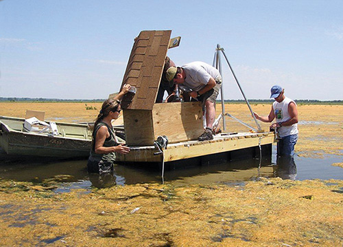
Maria Lemke and team installing a monitoring station.
1 The Agricultural Act of 2014 establishes the Agricultural Conservation Easement Program (ACEP). It repeals FRPP, GRP, and WRP but does not affect the validity or terms of any FRPP, GRP, or WRP contract, agreement or easement entered into prior to the date of enactment on February 7, 2014 or any associated payments required to be made in connection with an existing FRPP, GRP, or WRP contract, agreement or easement.

Additional Blog Posts of Interest
The Evolution of Water Quality Monitoring [Ebook]
Water Quality Monitoring Challenges | 1 of 5
Nonload Parameters in Surface Water | Dissolved Oxygen
Oregon's Tualatin River: America's Early TMDL Case Study