Water Quality Monitoring Protects Water Supply
The steep 500-meter (1,600-foot) peaks and dramatic canyons that have made the Shimen Reservoir one of Taiwan’s popular tourist attractions are the products of massive erosion – erosion that threatens the reservoir’s role as a key supply of domestic water.
The problem came to a dramatic head when Typhoon Aili unleashed 20 million metric tons of sediment and debris into the reservoir from the surrounding mountains.
Turbidity climbed from the usual 40 NTU to spike at 70,000 to 120,000 NTU. The sediment choked the reservoir’s water treatment plant, which was equipped to handle water with no more than 3,000 NTU. Tap water was cut off for days to thousands of households, and residents were forced to rely on water trucked in by the Taiwan Water Supply Corp.
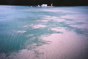
The typhoon was big – at 973 mm (38 inches) of rain, it represented half of a typical year’s precipitation – but it wasn’t unusual. The area around Shimen Reservoir is typically hit by two to four typhoons per year, and suspended solids discharged by landslides and erosion around the reservoir present a constant challenge to the Ministry of Economic Affairs’ Water Resources Agency’s Northern Region. Adding to the challenge, the sediments often travel in subsurface plumes across the 800-hectare (1,977-acre) reservoir, presenting a hidden hazard that can quickly overwhelm the dam’s water treatment facility.
Vertical Profiling
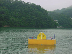
Before the next typhoon season, the Water Resources Agency deployed YSI Vertical Profiling Systems mounted to pontoons at two points in the reservoir. Each profiling system uses a YSI multiparameter sonde to conduct autonomous vertical profiles of the water column as the water approaches the Shimen Dam.
The YSI sondes report back to the dam’s operations office every three hours, logging turbidity, chlorophyll, pH and dissolved oxygen readings every five meters from surface to bottom. When turbidity reaches critical levels, the profilers’ data trigger an emergency plan at the water treatment plant, according to Bergius Su of Taipei-based Smartec, which provided and services the equipment. A team of technicians promptly begins a program of manual sampling to confirm the problem and determine its extent.
Finding the size, shape and depth of the plume allows the water treatment plant managers to choose among several management options:
- Accelerating the fill-up of the storage pond immediately above the water treatment plant;
- Closing any of the plant’s five drinking water intakes and opening others to draw in water from clearer levels in the water column and avoid the turbidity plume;
- Drawing water into the plant from a backup source in a nearby river.
Rugged Equipment
The vertical profiling system closest to the dam is anchored in 50 meters (164 feet) of water; the more distant sampling site is 40 meters (131 feet) deep. Forty-kilogram (88-pound) anchors hold the pontoons in place.
Those anchored floats have weathered several typhoons, though vertical profiling is sharply curtailed in rough weather. When storms hit, Smartec remotely locks the sondes in position immediately beneath the floating platform. At the dam management’s request, Su and his team can activate the sondes remotely or manually to sample at 10-meter intervals, or the Smartec crew can begin conducting manual readings with YSI sondes and grab-sampling equipment.
Smartec also conducts monthly calibrations and maintenance of the equipment. The team notes that the self-wiping feature of the sondes reduces the buildup of biofouling, and points out that calibration is a quick process. (Learn more about antifouling, 7 Tips to Fight Fouling and Extend Water Quality Sonde Deployments).
Data Flow
The sondes make their journey from the reservoir’s surface to the bottom and back every two hours, and report values via wi-fi for all parameters back to the dam office – about 5 kilometers (3 miles) away – every three hours. Their data are integrated with information gathered at eight grab-sample stations.
The data are primarily used for managing the dam and water treatment plant; however, the Water Resources Agency has also contracted with a professor from Taiwan University to develop a data-gathering and analysis protocol and develop a water quality model. Ultimately, data from the continuous vertical profilers could be integrated into the Shimen Runoff Forecast Model or the dam’s flood control operations.
The mission to track suspended sediment is important. Every year, landslides triggered by typhoons represent a significant threat to the water treatment plant at the Shimen Reservoir. Unattended monitoring of the water column helps ensure that the water treatment plant’s five intakes are opened and closed to draw clean water and avoid turbid supplies after typhoons, preventing costly damage to the plant and interruptions in the region’s water supply.

Additional Blog Posts of Interest:
Setting Up Floating Platforms for Continuous Lake Monitoring
Water Quality Monitoring Aids Conservation of Threatened Lake
10 Tips to Prevent Biofouling on Water Quality Instruments