Rapid Reservoir Surveys with Acoustic Doppler Profilers

Llyn y Dywarchen Reservoir, Rhyd Ddu, Gwynedd, Wales, United Kingdom
Situation
As the regulatory requirement to assess United Kingdom reservoirs and lakes expands to include smaller bodies of water, SonTek’s HydroSurveyor M9 system has been configured into a remote control boat so that hydrometric data can be obtained quickly, simply, safely, and accurately.
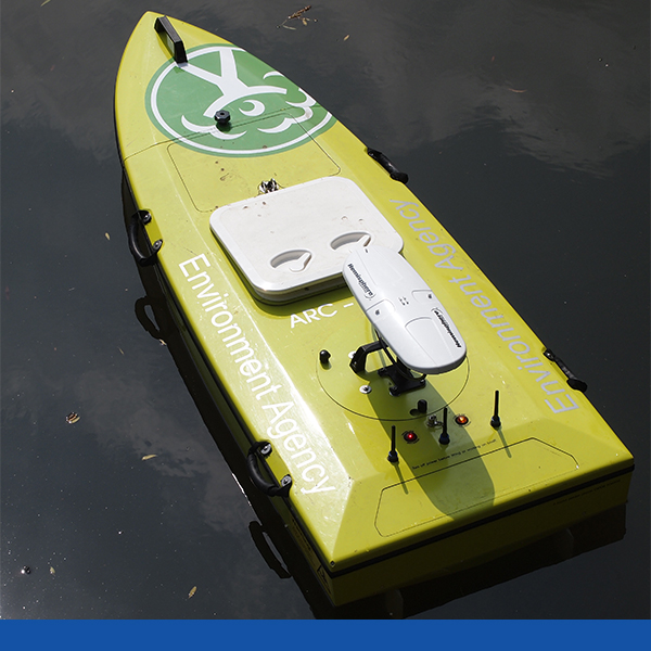
HR Wallingford developed the ARC-Boat and employs SonTek-proprietary Acoustic Doppler Profiler (ADP®) technology. The HydroSurveyor is a highly sophisticated system that includes 5-beam depth sounding, water velocity profiling, and navigation capabilities. When mounted in the ARC boat, the HydroSurveyor scans the reservoir as it is guided across the water’s surface. Recorded data is then analyzed by HydroSurveyor software to produce accurate depth measurements in addition to bathymetry maps of the entire water body. With a small amount of post-processing in GIS or 3-D CAD, an accurate water volume can be determined.
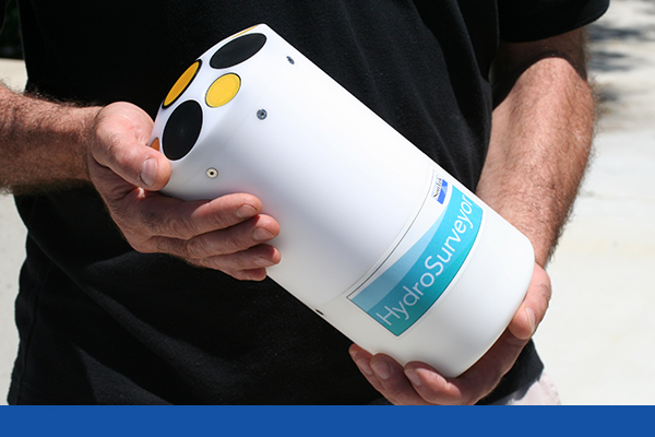
The HydroSurveyorTM is designed to collect bathymetric, water column velocity, currents profile, and acoustic bottom tracking data as part of a hydrographic survey. The two key components of the system are the HydroSurveyor Acoustic Doppler Profiler platform, and the powerful, yet user-friendly, data collection software.
Craig Goff, a reservoir Supervising Panel Engineer and dam specialist at HR Wallingford has used the ARC-Boat in a trial project to assess five reservoirs and says, “This new method offers tremendous advantages over traditional manned boat techniques because it is faster, safer, more environmentally friendly and involves fewer staff and resources. All of this combines to mean that it saves a great deal of time and money. This is particularly important because the Flood and Water Management Act 2010 will necessitate the volumetric assessment of many water bodies that have previously been below the threshold and therefore outside of the ambit of the Reservoirs Act 1975.”
Flood and Water Management Act 2010
Reservoir Regulations
As a result of residential and industrial development in recent decades, the levels of risk associated with many UK reservoirs has changed, and the Flood and Water Management Act 2010 has amended the Reservoirs Act 1975 to bring a more risk-based approach to reservoir regulation.
Flood and Water Management Act 2010
The reservoir sections of the 2010 Act are dependent upon the development of secondary legislation which is likely to specify the reservoir capacity above which water bodies will be regulated. Regardless, the Flood and Water Management Act 2010 has clearly generated an urgent need for reservoir assessment and the application of HydroSurveyor for reservoir bathymetry is promising.
Flood and Water Management Act 2010
Technology
The HydroSurveyor system employs a 9-beam ADP, using 5 beams at any one moment for depth measurements from a wide footprint on the water bed. This means that the time spent “driving” the boat is minimized in comparison with single-beam instruments. Notably, the HydroSurveyor can operate in depths ranging from 0.2m to over 40m.
The HydroSurveyor also incorporates built-in navigation, full water column velocity (currents) profiling, full compensation for speed of sound and integrated positioning.
ARC remote control boat in operation
The ARC-Boat has been designed with a V-shaped hull to give optimal maneuverability and minimal air entrainment beneath the ADP, allowing for unobstructed data collection. The design includes grab handles fitted to the upper deck, allowing the boat to be launched from the most difficult locations and a detachable bow means that the ARC-Boat can be transported in an average-sized car.
The boat employs industry-standard remote control with a minimum range in excess of 200m and Bluetooth communications provide data transmission to an onshore laptop.
Data Management
Nick Martin, a SonTek Application Specialist at Xylem Analytics UK says, “The HydroSurveyor is unique because it is the only product on the market that is able to make real-time corrections for thermoclines, saline stratification and the effects of boat pitch and roll.”
User-friendly software provides a central recording and processing platform that enables users to develop bathymetric maps, using properly gridded data points - a function that is automated and fully embedded in the software.
“Another one of the great advantages of the HydroSurveyor is its seamless integration with the CastAway-CTD for sound speed compensation of depth and current data. When used together, the data are interpolated in space and time to ensure high quality surveys” says Martin.
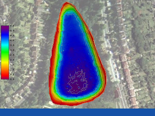
2-dimensional map of a reservoir following a survey
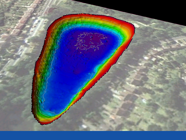
3-dimensional map of reservoir following a HydroSurveyor
Trial Results
Goff was extremely pleased with the results of the initial trials on five reservoirs in southern England. He says: “The HydroSurveyor performed very well, running from 8:00 am to 4:30 pm each day on a single set of batteries. We were able to conduct the surveys much faster than has ever been possible before, without the health and safety risks of putting staff over water and the environmental risks of diesel powered larger survey boats. Most importantly, however, we were able to produce high quality accurate data for a modest price and our client was very pleased with the results.”
Applications for HydroSurveyor
In addition to the smaller reservoirs that will have to be surveyed, larger reservoirs will be able to take advantage of the new technology to assist in operations such as the creation of sedimentation models. These models inform strategies to prevent capacity depletion and to extend the lives of reservoirs through flushing, excavation, dredging etc. Similarly, ARC-Boat surveys can be employed around submerged hydropower or draw off pipe intakes to assess sedimentation levels – a vitally important role because sediment can seriously damage turbines, or influence operation of scour pipes or water supply draw off pipes from reservoirs.
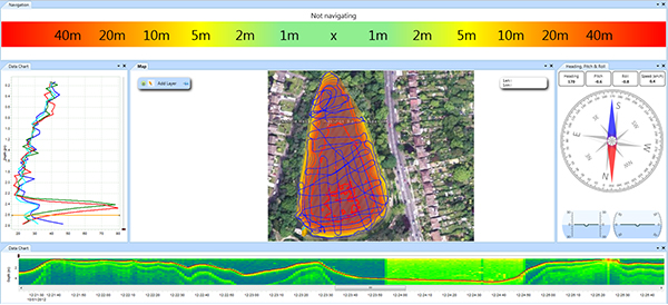
The HydroSuveyor software provides detailed information as the survey progresses.
Summary
As a result of the Flood and Water Management Act 2010, the owners of small reservoirs will need to prove whether their water bodies are affected by the amended Reservoirs Act 1975, by determining an accurate volume figure for their reservoirs. Typically, this will include landowners, farmers and organizations such as the National Trust. However, the development of the ARC-Boat with the HydroSurveyor system means that such work is now faster, safer and significantly lower in cost. This is good news for the owners of smaller reservoirs for whom any survey cost is a new cost.